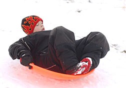
Matthew Nolan, 8, sleds down a hill along Mexican Dam Road Saturday. Photo by Brian Corley
More of the same unsettled weather is forecast for today and tomorrow, according to National Weather Service.
What's the forecast?
"Well, it's not sunny and warm," joked Mark Brown, a meteorologist with the National Weather Service in Reno.
The weather service's animated Doppler radar online shows a weak, patchy system moving over Carson City and the Sierra from the Northwest.
The system, which was expected to become a northeaster after midnight Saturday, should mean a slight chance of snow showers this morning. The rest of today, which is expected to be partly cloudy, will see highs in the 30s and winds peaking out at 10 to 20 mph.
Tonight should be partly cloudy and quite cold -- with lows in the midteens.
For Monday, National Weather Service forecasters are calling for a break in the unsettled, cloudy conditions. It should be sunny and clear with highs in the mid 30s. Monday night, with no clouds to hold in the heat, temperatures are expected to drop to 10 degrees above zero.
Tuesday it's back to the usual partly cloudy with another slight chance of snow showers. "There's just a 20 percent chance of showers on Tuesday," said Brian Brong, a meteorologist with the weather service in Reno.
It should be largely the same for Christmas: Partly cloudy with a narrow chance of snow showers. Lows are expected to be in the lower 20s. "Just a slight chance of snow for Christmas," Brong said.
INFORMATION
For highway conditions, call (877) 687-6237
or go online at: www.nvroads.com
or, on the radio, in Carson City tune into to 1610 am or in Reno or Lake Tahoe, tune in to 530 am.
Nation Weather Service on the net: http://www.wrh.noaa.gov/Reno/

Comments
Use the comment form below to begin a discussion about this content.
Sign in to comment