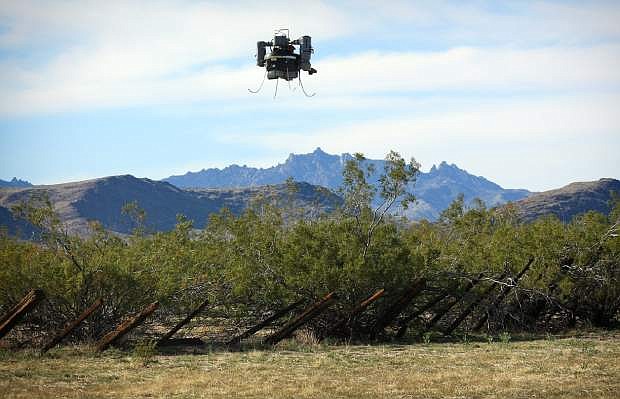
This photo provided by The U.S. Geological Survey, the USGS THawk drone being used during a survey of abandoned solid waste in the Mojave Preserve on Wednesday, April 3, 2013. The U.S. Geological Survey started using unmanned aircraft for wildlife and land management work about two years ago. Its first Nevada mission, planned for August or September, involves counting sheep and deer within the Desert National Wildlife Refuge north of Las Vegas. (AP Photo/Las Vegas Review-Journal, USGS)
LAS VEGAS — A few months from now, government agents with drones will descend on Southern Nevada to spy on the locals.
Luckily, mule deer and bighorn sheep don’t carry ACLU cards.
The U.S. Geological Survey started using unmanned aircraft for wildlife and land management work about two years ago. Its first Nevada mission, planned for August or September, involves counting sheep and deer within the Desert National Wildlife Refuge north of Las Vegas.
What used to require a helicopter and thousands of dollars’ worth of fuel can now be done with some fresh batteries and what looks like an elaborate toy plane no bigger than a turkey vulture.
Mike Hutt, who heads up the Geological Survey’s National Unmanned Aircraft Systems Project Office in Denver, says there has been a “groundswell” of Department of Interior drone use in recent years, as cash-strapped field offices look for ways to do more work with less money.
In coming months, the USGS plans to use unmanned aircraft to track eagles and trumpeter swans in Idaho and Washington state, spot invasive plants at Utah’s Zion National Park and search the Oregon coast for debris from the 2011 tsunami that struck Japan.
Hutt says that his agency got its first military-surplus drone in 2009 and flew its first real mission in 2011. His office now has about a dozen missions under its belt, with at least nine more planned later this year.
Widening domestic use of unmanned aircraft comes as the American Civil Liberties Union and others call for clear policies and restrictions designed to prevent the creation of a “surveillance society.”
Hutt is sensitive to privacy concerns and says virtually all his office’s work takes place on public land: “When we fly we let people in the local area know and invite them out. We try to be as transparent as possible.”
With rare exception, the drones operate at no more than 400 feet altitude and at least five miles from the nearest home. “We don’t fly over populated areas,” Hutt says.
In fact, they rarely fly over private property. When they do, they get written permission from the land owner in advance. They also have to get Federal Aviation Administration clearance.
The Geological Survey now has drone systems stationed in Alaska, Arizona, Colorado, Idaho and Montana, and uses two types of aircraft: a battery-powered, fixed-wing airplane called the Raven and a gas-burning helicopter called the THawk.
Neither resembles an advanced, unmanned warplane such as the Predator or the Reaper. These look more like something you might buy in a hobby shop.
The Raven weighs less than five pounds and measures less than five feet from wing tip to wing tip. It is easily lifted with one hand and launched into the air the way you might toss a paper airplane.
It flies quietly, but landings are rarely pretty. The plane is designed to break apart on impact to avoid permanent damage, so there is often some assembly required before the next flight.
At 18 pounds, the THawk is heavier and less graceful in the air, but it provides more stable images because it can hover. The trade-off comes in the form of noise and general obnoxiousness.
“It sounds like a chain saw flying overhead,” Hutt says. “It’s been described as a flying trash can.”
Drone pilots also seem to prefer one vehicle over the other.
“The Raven is pretty fun,” says Jeff Sloan, a cartographer by trade who now gets to steer unmanned airplanes with a hand-held controller any young hobbyist would probably recognize. “I imagine teenagers are better at flying them than us older guys.”
The THawk is steered with a laptop computer.
Both drone systems are small and light enough for easy transport. Depending on how far they have to go for a mission, operators either transport the aircraft to the site by ground or ship them by overnight mail.
The Raven tends to be better for wildlife work because it is quieter, though drone operators have been surprised by the reaction — or lack of one — they have gotten so far from some of their THawk surveillance subjects.
“We flew 75 feet over sandhill cranes, and they didn’t seem to pay any attention to us as they roosted at night,” Hutt recalls. “I think critters in the field grow to accept certain things as a threat, and they don’t see us as a threat yet.”
Last month, Sloan and company traveled to Mojave National Preserve in California, about 80 miles south of Las Vegas, where they scanned several square miles from the air in search of trash piles and illegal dump sites for eventual cleanup.
OTHER USES FOR IMAGES
After looking at the high-resolution pictures from the drone, the staff at the desert park dreamed up other uses for the images, including a Joshua tree inventory and a study of invasive weed concentrations.
Sloan says that happens a lot. Once people see what the machines are capable of, they want more. “‘Can you do this while you’re up there?’ That’s pretty typical,” he says. “Really the applications are limitless.”
Hutt says that drones could prove useful for finding missing hikers, spotting wildfires, monitoring crops, refining maps, surveying archaeological sites and inspecting canals, power lines, pipelines, fences and dams.
Already, biologists use them to track and count protected species, including some that seem too small and well-camouflaged to be spotted from the air.
Sloan recently used drones outfitted with thermal and high-definition cameras to identify and count sage grouse in Colorado. The birds are about the size of an average chicken, but the crew was able to spot them from 150 feet above.
“I didn’t think it would work,” Hutt says.
Once the FAA approves a mission, the drone team can deploy in just a few days.
The work is done on the cheap by using off-the-shelf equipment such as the high-definition cameras now favored by skydivers, snowboarders and dirtbike riders who like to film their death-defying stunts.
The drones have “close to zero maintenance and operational costs,” so a week-long mission like the one planned in Nevada can be done for as little as $3,000 in labor expenses.
The standard way of counting bighorn sheep and mule deer — namely by putting people in a helicopter — typically costs $20,000 to $40,000, Hutt says.
FOLLOW-UP COUNT
After an initial count in August or September, the drone crew will likely return to the desert north of Las Vegas next spring for a follow-up count of newborn lambs and fawns.
Coincidentally, the search area is not far from Creech Air Force Base in Indian Springs, a hub for the military’s considerably less benign use of unmanned aircraft.
Hutt and Sloan say they have no plans to arm their drones and try to use them, for example, to tranquilize large game. But you could tell the suggestion got their wheels turning.
“I think we’re just scratching the surface. Every time we go out, we have a hundred other ideas,” Sloan said.
———
Information from: Las Vegas Review-Journal, http://www.lvrj.com

Comments
Use the comment form below to begin a discussion about this content.
Sign in to comment