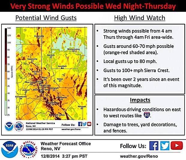
Winds the like of which Western Nevada has not seen in two years are expected to blast through the area late tonight, according to the National Weather Service, with as much as eight-tenths of an inch of rain forecast later in the week.
In a statement issued Tuesday afternoon, forecasters said widespread winds of 35-55 mph are expected, with gusts of 60-75 mph, with localized gusts of up to 90 mph in wind prone locations.
“We have not had a wind event like this since early 2012,” meteorologists said. The wind advisory was set for 10 p.m. Wednesday through 4 a.m. Friday as the storm moved in from the Gulf of Alaska.
Strong winds with the potential to cause damage are expected. Hazardous driving conditions are expected for high-profile vehicles traveling along Highway 395 or Interstate 80.
The National Weather Service has issued a winter storm watch for the Sierra with 1-3 feet of snow possible above 7,000 feet. Snow levels are expected to drop to 5,000-5,500 feet on Thursday night, with some bands lowering snow levels to lake level early on Thursday.
“Questions remain regarding (how) fast snow levels will fall in this storm,” meteorologists said. “The differences in the forecast … cast doubt on snow amounts in the Sierra and Northeast California below 7,000 feet. If snow levels fall fast enough, the Sierra valleys below 7,000 feet could see significant snowfall … but if the snow levels fall slower, snowfall amounts will be much less.”
Wind and snow could combine for local blizzard conditions on the highest passes. Damage to trees, power lines, property and holiday decorations are all possible with the strong storm.
“Falling and blowing snow with strong winds and poor visibility are likely,” the warning said. “This will lead to whiteout conditions, making travel extremely dangerous. Do not travel. If you must travel have a winter survival kit with you. If you get stranded, stay with your vehicle.”
In Carson City, Thursday during the day, there’s a 20 percent chance of rain. That chance becomes 100 percent Thursday night. The Weather Service said rain is likely to continue into Friday before changing to snow. The Weather Service stated the storm could bring as much as eight-tenths of an inch of rain to the area.
The storm is expected to clear Saturday.
Ahead of the storm, the NWS issued a high wind and flash flood warning in preparation for a strong storm headed to the San Francisco Bay Area.
The National Weather Service in Monterey, Calif., said this storm is “expected to be one of the strongest storms in terms of wind and rain intensity” since storms in Oct., 2009 and Jan., 2008, respectively.

Comments
Use the comment form below to begin a discussion about this content.
Sign in to comment