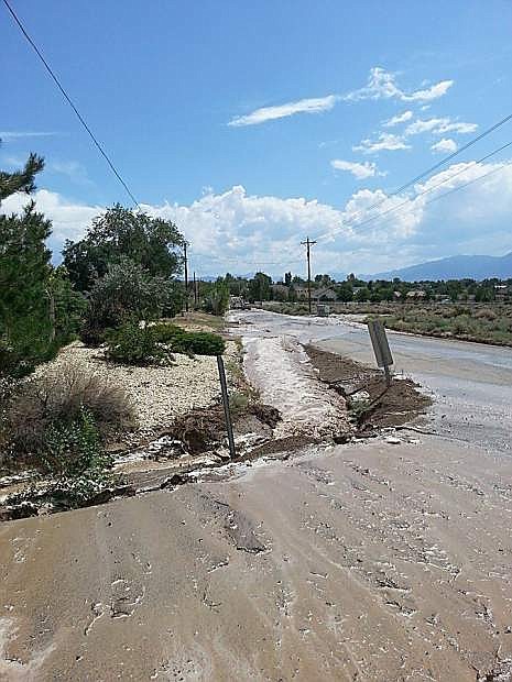
Water rushes over the road on Aug. 11.
Multiple requests for an emergency declaration from the governor from the summer’s flooding continue to go without an answer 80 days after the last storm struck Douglas County.
The county has yet to report an answer from the governor’s office on three emergency declarations made on Aug. 11 and Aug. 21. If approved by the state, the declarations could help with funding to restore public infrastructure to its former level.
“Flood control projects are currently being sought after and we are dedicated to exploring every available opportunity to help identify or reduce flood risk,” Douglas County Engineer Erik Nilssen said.
A September request by the county to the Army Corps of Engineers to build temporary flood control structures was denied because the county hadn’t demonstrated an imminent threat to the area, county spokeswoman Melissa Blosser reported on Monday.
The Corps is preparing a cost estimate to create an area drainage master plan for the Johnson Lane Area under the Planning Assistance to States program, Blosser said.
If approved, the plan would identify projects that could be constructed to alleviate flood problems within the Johnson Lane area.
Johnson Lane, East Valley and Fish Springs were the main subjects of flooding prompted by monsoonal moisture on July 20, July 30 and Aug. 6.
Even as the first of three emergency declarations on Aug. 11 was sought, heavy rain sent water rushing along Johnson Lane in a fourth flood.
The biggest of the floods, the July 20 inundation of the north Valley neighborhoods at the base of Hot Springs Mountain, started out a series of monsoon related storms.
According to a rain gauge at the base of the mountain, 1.23 inches of rain fell over the course of two hours prompting a 100-year flood.
County drainage facilities designed to handle a 25-year flood were overwhelmed by the 100-year flood.
A much smaller flood closed East Valley Road on July 30. After that flood it was predicted it would take six weeks for county road crews to clean up the area.
Fish Springs residents faced a long night on Aug. 6 when a storm dropped an estimated 2 inches of rain near Mount Siegel on the evening at 8:45 p.m. Firefighters responded to a lightning strike in the area where flooding was reported.
A grant was obtained through the Carson Water Subconservancy District to study a potential detention basin on Smelter Creek on the east side of Ruhenstroth. It’s estimated the basin would capture floodwaters coming out of the Pine Nut Mountains and allow the water to flow out at pre-flood conditions. It’s expected the basin would remove 98 parcels from the 100-year floodplain and an additional 82 parcels from the 500-year floodplain. This study would locate and size the basin and overflow structure as well as produce a cost estimate and cost benefit analysis to allow the county to submit for a construction grant.
Douglas County staff and East Fork Fire Protection District, representing Douglas County Emergency Management, will be at the Douglas County Library on Nov. 10 and Nov. 14 handing out literature for flood preparation in recognition of Flood Safety Awareness Week.
Also on display will be updated flood plain maps of the Johnson Lane Area in Douglas County.
A grant was obtained through the Carson Water Subconservancy District to study a potential detention basin on Smelter Creek on the east side of Ruhenstroth. It’s estimated the basin would capture floodwaters coming out of the Pine Nut Mountains and allow the water to flow out at pre-flood conditions. It’s expected the basin would remove 98 parcels from the 100-year floodplain and an additional 82 parcels from the 500-year floodplain. This study would locate and size the basin and overflow structure as well as produce a cost estimate and cost benefit analysis to allow the county to submit for a construction grant.
Floodplain maps are being updated for the Johnson Lane, Buckbrush, Airport and Sunrise washes. The floodplain maps completed by FEMA in 2010 were found to be in error and Douglas County has been working with Kimley Horn Engineering Consultants to produce more accurate floodplain maps. The preliminary maps are completed and accepted by FEMA. It’s expected the new maps will be released to the public in early 2015.
Douglas County has also received a grant through FEMA to restudy the floodplain limits in Alpine View Estates.
The subconservancy is evaluating the floodplain limits of the Carson River from Alpine County to Churchill County.
Douglas County in partnership with the Nevada Department of Transportation is expanding the culverts under Highway 395 just south of Muller Parkway intersection. The culvert expansion will allow the floodwaters from a 100-year flood event to flow underneath the highway. Douglas County has also received notice a proposed project that would add additional culverts under State Route 88 at the Cottonwood Slough has been approved for grant funding. These culverts would provide additional flow capacity under the State Route 88 bridge which would remove potentially 99 residences from the primary floodplain.
The county has set up a Web page dedicated to flood information in Douglas County where the history of recent flash flooding and the most current information on County Flood Projects can be found at www.douglascountynv.gov/1072/Flash-Flooding.
More information on the flooding in Nevada and additional resources can be found at www.nevadafloods.org/.

Comments
Use the comment form below to begin a discussion about this content.
Sign in to comment