TAHOE CITY, Calif. — North Lake Tahoe and Truckee are loaded with amazing mountain biking trails.
There are easy routes with smooth dirt and gentle climbs that are well suited for beginners; there are miles of intermediate terrain; and then there are trails that will satisfy the endorphin desires of the experts, while leaving the less-experienced riders proclaiming, “Oh My God, we are not seriously going to ride down that, are we?”
The sprawling network of trails at Tahoe Cross Country Ski Area/Burton Creek State Park provides riding for all those ability levels in one location.
The Tahoe XC/Burton Creek trails can be accessed from a variety of locations, including the top of Jack Pine in downtown Tahoe City, behind Tamarack Lodge, a mile east of Tahoe City, or my go-to spot, the trailhead of Tahoe XC Ski Area in the Highlands.
There, you will find plenty of parking, a porta-potty, and a chance to warm up slowly since the trails head out gently as opposed to the steep climbs you will immediately face from the other trailheads.
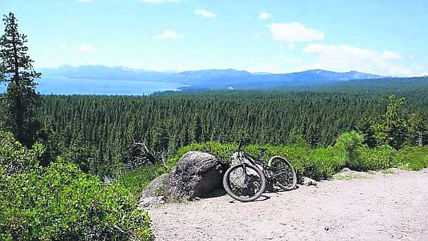
Dozens of miles of trails wind through thousands of acres of forest from Watson Lake and Northstar in the north, to Tahoe City and Carnelian Bay in the south.
You can even access the Truckee River between Squaw Valley and Alpine Meadows via the Western States Trail.
Don’t do it all at once, however — you have years to explore.
ENDLESS OPPORTUNITIES
Begin by focusing on the trails close to the Tahoe XC trailhead. In a two-hour ride from the lodge, you will find panoramic views of the lake, rolling easy terrain through fields of mule ears, and long, challenging climbs.
The Tahoe Rim Trail snakes through the area, as well as the Fiberboard Freeway, a paved Forest Service Road, which serves as a central artery from which other trails branch off.
There are bumpy trails on which you can catch some air, and downhills so steep they’ve been given names like The Elevator Shaft and The Wall.
But don’t worry — there are plenty of loops to make it easy to design a ride that matches your ability level.
The bad news is that trail network is so extensive and convoluted it’s impossible to give you directions where to go.
The good news is that a series of maps have been placed at intersections to provide somewhat of an idea where you are. A good review of the Tahoe Cross Country Ski area map at the trailhead is also recommended.
LOOK FOR THESE TRAILS
Big Bumps: It follows the route of The Great Ski Race from what skiers call the Orange trail to the Fiberboard Freeway. It’s a steady climb up, and a fun series of bumps on the way down.
Little Bumps: This trail takes off from the Purple trail, and is a fun, gentle downhill with lots of little bumps.
Lakeview Trail: It lives up to its name with spectacular views of Lake Tahoe, as well as the Pacific Crest … all a necessary reward after the steep climb to get there. A bench and picnic table are found here, so it makes for a great lunch spot.
Dollar Reservoir: A right turn after the first water tower brings the rider down to the tiny Dollar Reservoir, which is followed by a long steady climb.
Tahoe Rim Trail: At the top of the Big Bumps Trail, take a right and follow the Fiberboard Freeway for a mile to an intersection with the Tahoe Rim Trail. A left turn takes you steeply up to Painted Rock, where a view into Squaw Valley can be found, followed by some tricky winding downhills to The Wall.
A right turn takes you over smooth, gentle climbing that is even more fun coming back down. If you keep riding past the first junction on the TRT you will find nice expansive lake views on a long gentle descent, before the trail gets steeper and more challenging at the next junction.
Tim Hauserman, a nearly lifelong resident of Tahoe City, is a freelance author and cross-country ski instructor. He may be reached at writeonrex@yahoo.com.

Comments
Use the comment form below to begin a discussion about this content.
Sign in to comment