The picturesque Mormon Station State Historic Park is just one of the many attractions found along State Route 206 through the Carson Valley.
Carson Valley has always been one of Nevada’s special places. Intersected by the Emigrant Trail — the route that many early pioneers used to travel to California — the lush, green valley was among the earliest places settled in the state.
In the 1850s, a correspondent for a San Francisco newspaper was so taken by the valley’s fertile grasslands—which were ideal for grazing horses and cattle—that he described it as a “paradise for quadrapeds” (now that’s a catchy slogan—would work well in an ad campaign).
The first permanent settlement in the valley was Genoa, which was founded by Mormon traders in 1851. Additionally, a handful of other, mostly forgotten, hamlets sprouted along the valley’s western edge, in the shadow of the Sierra Nevada range. These communities, with names like Mottsville, Sheridan, Fairview and Centerville, catered to travelers.
But while these town names are largely gone, it’s still possible to retrace the route along the valley’s west side and, despite recent development, catch glimpses of the region that carried such appeal for the pioneers.
The best place to start the journey is at the intersection of U.S. 395 and State Route 206 (Jack’s Valley Road), located about 5 miles south of Carson City. The road initially runs west toward the mountains, through a largely residential area.
A few miles along, the road gradually turns south, passing by beautiful pasturelands that bump up against the mountains. The road passes newer developments on the outskirts of Genoa, such as the Little Mondeaux, Genoa Lakes, and others.
In a few places, however, the old Carson Valley peeks through. For instance, a few miles before Genoa, hidden in tall trees below the road, is the historic Adams House.
Built in the early 1860s, the two-story, white-pillared brick structure was once a hotel for travelers. Today, it is a private residence still owned by members of the Adams family.
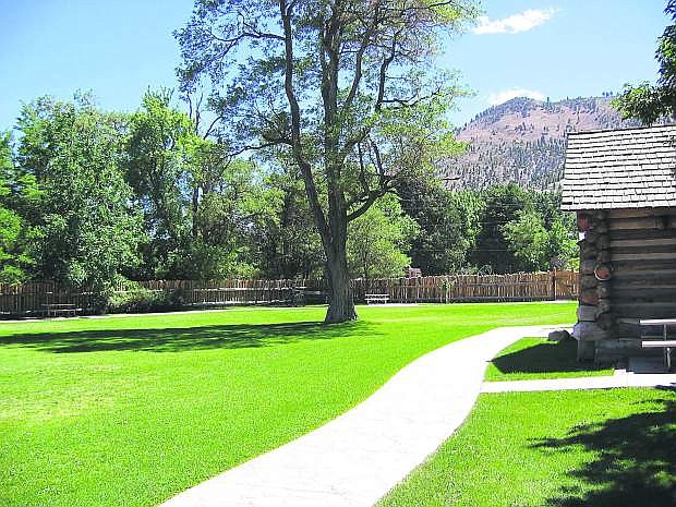
The road continues through picturesque Genoa, a community filled with historic homes and buildings as well as the Mormon Station State Historic Park, a replica of the state’s first permanent structure. The park boasts a beautiful picnic area in a quaint setting.
From Genoa, the route passes Walley’s Hot Springs Resort and the area begins to lose a bit of its built-up character, offering views of open grasslands and beautiful mountain peaks.
Farther south, the road, now called Foothill Road, passes Van Sickle Station, site of what was once the largest hotel on the trail. Built by Henry Van Sickle in 1857, over the years it served as a trading post, freight station, Pony Express station and stagecoach stop.
Today, it’s a state park facility. Several of the original buildings remain standing.
One of the more colorful early Nevada stories, in fact, involves Henry Van Sickle. According to some accounts, one of early Nevada’s worst outlaws was a man named Sam Brown.
In the early 1860s, Brown, who is believed to have killed more than a half dozen men, attended a friend’s trial in Genoa hoping to intimidate the jury into releasing his associate. At the door, however, he was told he could only enter the courtroom if he relinquished his weapons.
He rode off, arriving in a foul mood at Henry Van Sickle’s ranch, which also served as an inn. According to some stories, he then fired his gun, for no apparent reason, at Van Sickle, who was standing on his porch, then chased Van Sickle through the house.
Unable to catch the rancher, Brown rode off to Carson City. Van Sickle, in turn, grabbed his shotgun and took off after Brown. He caught up with the outlaw and, after trading several shots and a lengthy chase, killed Brown.
Van Sickle, who was later found to have acted in self defense, is said to have told Brown just before shooting him, “I got you and I kills you.”
A little farther up the road is the site of old Kingsbury Grade road (an historic marker notes the spot). While earlier called the Georgetown Trail and Dagget Pass Trail, it became known as Kingsbury Grade in honor of one of the builders of an 1860 wagon road that crossed the Sierra range here. A mile farther is modern-day Kingsbury Grade.
Six miles south of Genoa is a sign noting the former location of Mottsville. The settlement was named for Hiram Mott, an early Carson Valley rancher.
The Mott family was prominent in early Nevada history. Hiram Mott’s daughter-in-law, Eliza, was one of the first non-Indian women to settle in the state. The Mottsville Cemetery, which is still there, was among the state’s first cemeteries, having been established in 1857.
A few miles farther south is the former site of Sheridan (another historic marker notes the site). Founded as a general store for travelers in 1855 by Moses Job (namesake for nearby Job’s Peak, the tall mountain to the west), within a few years a town grew up on the site.
For a brief time, Sheridan was the largest community in Carson Valley, but by the late 1890s it had begun to decline. Today, only a handful of original structures can still be found hidden amongst newer houses.
From here, the road passes a handful of small farms and plenty of open land. It’s pretty country that speaks of the kind of place most of the Carson Valley was once.
About 30 miles from where the journey began, the road turns east and ends at State Route 88. From here, you can return north to U.S. 395 at Minden or head south to Markleeville, California.
A good book about the history of the area is Grace Dangberg’s “Carson Valley,” published by the Carson Valley Historical Society.
Rich Moreno covers the places and people that make Nevada special.

Comments
Use the comment form below to begin a discussion about this content.
Sign in to comment