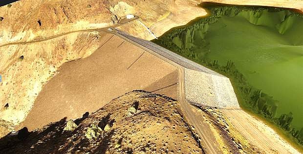
The Phantom 4 drone was used to produce three-dimensional images of the Brunswick Canyon dam and reservoir where Carson City stores its reclaimed water in the winter.
Carson City Public Works is getting a bird’s-eye view of its projects and property thanks to a small drone.
In September, the department purchased for about $1,000 a DJI Phantom 4, the most popular recreational unmanned aerial vehicle, as well batteries and a dedicated iPad to operate it.
The 3-pound device comes equipped with a camera for imaging and four more used to detect any obstructions in its path, and can be flown no more than 400 feet above the ground, according to Federal Aviation Administration rules.
“We’re working on a proof of concept to determine what its capability is for Public Works,” said James Jacklett, operations manager, control systems, for the department. “We’ve been using it for maintenance inspection like solar panels, the Mexican dam, the ditch, the landfill.”
The department has long used consultants who fly aircraft to take aerial imagery of property, disaster sites, and the city’s roads for various purposes such as data collection and permitting.
But a drone could allow the city to do some of that work for far less money and on a more timely basis.
“We’re not looking to replace other services,” said Jacklett. “We’re keeping it focused right now to determine the value.”
For example, the drone is being used to survey the $30 million construction project now underway at the Water Resource Recovery Facility on 5th Street.
The project management team has asked for a monthly drone flight to supplement record keeping on the project.
“To fly the wastewater plant takes 12 minutes to cover 49 acres,” said Jacklett.
In those dozen minutes, the drone flies a programmed grid back and forth above the site, taking 309 photos which are later stitched together via software to create two and three dimensional images of the entire plant.
The $99 software, called DroneDeploy, also can be used to measure the volume of a pile of material on the ground or the height of an object.
The drone has flown the city landfill, too, to measure material there, and the results were compared to existing data to determine its accuracy.
“We’re still evaluating it, so if we can supplement or replace our annual permit flight,” said Jacklett. “Every year we have a light aircraft do a flight.”
The drone has also photographed the 4-mile Mexican Ditch, an approximate 3-hour flight that could potentially replace days of on-ground surveying.
The Phantom 4 also has been used at the Public Works office, to check on solar panels on the roof of one outbuilding as well as the communications tower there.
The photos are mostly devoid of people. FAA regulations allows the drone to be flown only over flight crew, which does limit its application.
So far, outside training, the pilots have taken the drone out for about 20 flights, said Jacklett.
He and Rit Palmer, water operations supervisor, and Brandon Mathiesen, water production foreman, are all licensed to fly the device, which requires an FAA pilot’s license.
Eventually, if the drone proves useful and valuable, the city could invest in more, especially if prices come down as anticipated.
“This one had the most safety features and was a good value,” said Jacklett. “I expect this whole sector to move fast.”

Comments
Use the comment form below to begin a discussion about this content.
Sign in to comment