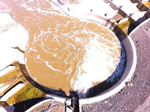
In this drone shot taken Saturday, water from one side of the Lahontan Dam fills a "bowl" that dissipates the water's energy after it's released quickly from the dam.
This weekend is shaping up to be a chess game between Mother Nature and agencies that monitor and control water such as the Truckee-Carson Irrigation District.
An early April storm termed “uncommon” for this time of year is expected to arrive in western Nevada and the Sierra on Thursday. Meteorologist Scott McGuire of the National Weather Service in Reno said Tuesday this weekend’s atmospheric system, which is rare for early April, could bring up to 1-to-4 feet of snow in the higher elevations and rain in the valleys for several days.
“This will be a very strong storm, one of the strongest we have seen at this time of year,” McGuire said. “This storm will be pretty significant.”
McGuire said people who live near the regions rivers including the Carson River that runs through Churchill County, must pay attention to weather forecasts through the weekend.
“We’re seeing rises in the rivers but no flooding at this time,” McGuire said. “But if there is a change in weather, it could affect snow levels.”
As of mid-week, McGuire said if the weekend system keeps snow levels at the 6,500-7,500 elevation, then the NWS is not expecting major problems; if the system trends warmer with snow levels at 8,000 feet and rain at the lower elevations, then runoff could be more pronounced.
“The biggest take away is that this will be a significant spring storm with windy, wet conditions,” he added.
So far this spring, McGuire said the snow has melted at the lower elevations, but a sudden warming trend would speed up the runoff.
McGuire also gave the LVN snowpack measurements and precipitation content for three areas: The Lake Tahoe Basin is 221 percent of average followed by the Carson Basin with 207 percent. He said the Truckee River Basin is 196 percent above average. In terms of water content, he said the amount in the Sierra Nevada ranges from 72.1 to 83.7 inches.
The weekend weather is also on the mind of Rusty Jardine, TCID’s general manager. Once TCID receives approval for emergency work done on the Lahontan Dam, he said the Carson River east of the reservoir could be ramped up to 2,800 cubic feet per second (cfs) as early as today or near the end of the week. Jardine said the concrete repair to the right discharge tunnel at Lahontan Dam has been completed, but TCID is awaiting test approval to open the outlet.
Jardine said residents may have noticed a slight decrease in flows on Tuesday when the Bureau of Reclamation conducted its tests and inspection on the left tunnel.
Jardine said progress on cleaning and lowering the diagonal drain southeast of Fallon should be finished in about three weeks. “The Big Dig” is a channel that will take water from Carson Lake to the Stillwater Point Reservoir and eventually to the Carson Sink. Jardine said the channel will move water away from low-lying property owners in the valley.
Jardine, though, reminds residents living near the Carson River to be vigilant of the faster moving water. McGuire added flood mitigation efforts must remain ongoing because of this week’s weather system.
The Nevada Department of Transportation said U.S. Highway 50 east of Fallon is closed and motorists are being re-rerouted. Electronic traffic signs announcing the detour have been set up on Fallon streets. Work to install drainage culverts is expected to be done by Thursday; however, NDOT said work could be done as early as Wednesday tonight.
Macari Lane will then be closed for several months starting at the end of next week.

Comments
Use the comment form below to begin a discussion about this content.
Sign in to comment