The Tahoe Douglas Fire District is planning six prescribed burns around the Tahoe Basin.
The burns provided the smoke that hit Eagle Valley on Wednesday.
The winds picked up in front of a system that’s expected to hit the region Thursday. The National Weather Service in Reno has issued a wind advisory from 11 a.m. Thursday until 11 p.m. Friday.
Winds are expected from the south to southwest from 20-40 mph with gusts up to 55 mph. Local gust in wind prone areas could reach 70 mph.
Travel will be impacted. Power outages are likely.
The system, which is expected to bring rain to the valley, could result in up to 2- to 4-feet of snow above 7,500 feet and 4- to 8-inches at lake level.
The amount of precipitation has caused a flood watch to go into effect tonight through Saturday. NWS says the system isn’t expected to be as significant as the January and February systems, but the already full rivers and streams can’t handle much more precipitation without causing flooding. The flooding is expected Friday and Saturday.
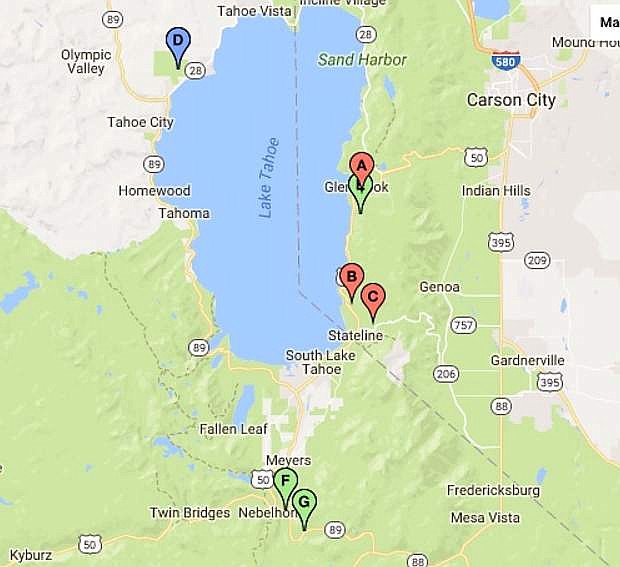
Current prescribed burns in the Lake Tahoe Basin:
Community Piles II
Glenbrook Area
Responsible Agency/Contact: Tahoe Douglas Fire District Keegan Schafer (775) 848-6277
Type of Burn: Hand Piles
Total Acreage: 30
Planned Ignition: 4/5/2017
Duration of Ignition and Smoke Production: 2-3 days of burn down time
Esimated Direction of Smoke Travel: North/Northeast
Communities or Smoke Sensitive Areas: Smoke may be visible from Glenbrook and Hwy 50
B
Edgewood Creek Area
Responsible Agency/Contact: Tahoe Douglas Fire District Keegan Schafer (775) 848-6277
Type of Burn: Hand Piles
Total Acreage: 40
Planned Ignition: 4/6/2017
Duration of Ignition and Smoke Production: 2-3 days of burn down time
Esimated Direction of Smoke Travel: North/Northeast
Communities or Smoke Sensitive Areas: Smoke may be visible from Kingsbury Corridor
C
Lower Kingsbury Area
Responsible Agency/Contact: Tahoe Douglas Fire District Keegan Schafer (775) 848-6277
Type of Burn: Hand Piles
Total Acreage: 15
Planned Ignition: 4/6/2017
Duration of Ignition and Smoke Production: 1-2 days of burn down time
Esimated Direction of Smoke Travel: North/Northeast
Communities or Smoke Sensitive Areas: Smoke may be visible from Kingsbury Corridor and surrounding niegborhoods.
D
Burton Creek State Park
Between North Tahoe High School and Rocky Ridge Properties
Responsible Agency/Contact: California State Parks, Rich Adams (530) 525-9533
Type of Burn: Hand Piles
Total Acreage: 30
Planned Ignition: 4/3/2017 and continuing as conditions permit
Duration of Ignition and Smoke Production: 1 month
Esimated Direction of Smoke Travel: East
Communities or Smoke Sensitive Areas: North Tahoe High School, Highlands, Lake Forest, Rocky Ridge, Tahoe City
E
Summit 35
HWY 50 and Logan Creek Drive
Responsible Agency/Contact: US Forest Service, Kyle Jacobson (530) 543-2658
Type of Burn: Hand Piles
Total Acreage: 50
Planned Ignition: 4/3/2017
Duration of Ignition and Smoke Production: 4 days
Esimated Direction of Smoke Travel: Northeast
Communities or Smoke Sensitive Areas: Logan Creek/ Cave Rock/ Glenbrook
F
Monitor 93
Hwy 89/ Grass Lake Road
Responsible Agency/Contact: US Forest Service, Kyle Jacobson (530) 543-2658
Type of Burn: Hand Piles
Total Acreage: 20
Planned Ignition: 4/3/2017
Duration of Ignition and Smoke Production: 2 days
Esimated Direction of Smoke Travel: southwest
Communities or Smoke Sensitive Areas: Christmas Valley

Comments
Use the comment form below to begin a discussion about this content.
Sign in to comment