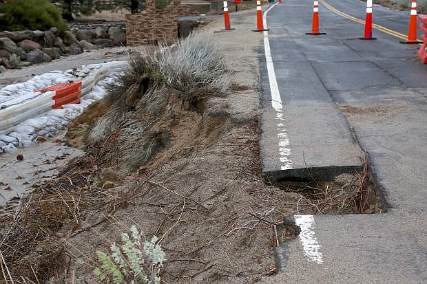
Combs Canyon Rd. has a section of pavement missing Friday due to floodwaters.
This week’s storm is either ironic or nature is generating some serious sorcery; the Carson River crest reached major flood stage at midnight Friday — and the same thing happened exactly a month ago, almost precisely.
On Friday, the Carson River crest reached 11 feet and elevated to 11.2 by Friday morning. On Jan. 10, the Carson River gage hit 11.1 feet when the first catastrophic storm visited the region, said the National Weather Service in Reno. Meteorologists said there’s no other winter that compares to what they have seen in the region for the last 12 years.
For the past day, river crests have been rapidly rising near Fort Churchill, from Carson City to the Lahontan Reservoir. However, crest levels in creeks such as Ash Canyon, Kings Canyon and Eagle Valley calmed down.
NWS said we could expect to be out of the storm system Friday, with a five-day break ahead. But more storms are in the forecast for Thursday evening, followed by another one Saturday into Sunday of next week. Potentially, there’s another storm on the way — but that could easily change, said the National Weather Service.
According to the U.S. Geological Survey Water Science Center in Nevada, hydrologists are scattered throughout the northern region measuring and providing data on river information. Northern Nevada USGS Chief Marsha Gipson said this weather event has more of an impact compared to the one a month ago; data is being collected at the Carson, Humbolt, Truckee, and Walker rivers, whereas teams only focused on one area in January.
But the National Weather Service suggests those who live in Lyon County need to take river forecasts seriously and stay away from major flooded areas. National Weather Service also said, as a region, we have our backs up against the wall; the environment can’t handle any more storms after this point. It’s important to constantly prepare for floods at anytime with a vigilant attitude, as the remainder of this season will be active and wet.
Lyon County Manager Jeff Page said drainage problems in the area reduced substantially and most of the flooding occurred in rural and field areas. Non-maintained roads were closed to protect further damage.
Public safety resources have been stretched the last 24 hours for Carson City, said Sheriff Ken Furlong.
“So far, we have all been consumed by calls today,” Furlong said.
However, it looks like Carson will be in the clear soon.
“Right now, we are in the recovery stage,” said interim Fire Chief John Arneson. “We are heading out of this event: the weather is cooperating, we are just waiting for the river to peak out and get by us. But we are on the backside of this storm.
“Some of the smaller streams are starting to slow down and the river isn’t expected to crest until 10 or 11 p.m., so we will still have some localized flooding and Nevada Division of Forestry is working with us to help sandbag and clear trees.”
Carson City Public Works has been busy, keeping drainage systems clear, clearing debris and rerouting water in areas around Carson.
“Public Works has been working extremely hard and the Fire Department and Sheriff’s Office are doing our best to support them,” Arneson said. “They have been extremely busy, but they are doing a great job to do everything they can.”
The city also has several assessment teams out to check on flooded areas, homes and businesses. Arneson said they’ve had reports of some residences and businesses, such as the Carson Mall and King Street, that have been impacted by the weather.
“King Street was basically a river last night,” Arneson said. “So Public Works is trying to divert the water and control it to get it to go to some different places (so it can drain).”
Though the weather is subsiding, it’s still best to avoid driving if possible, Arneson said. Several intersections and roadways are still trying to drain, so while water on the road may look shallow that may not be the case.
“If you don’t have to go out, don’t do it,” Arneson said. “Be careful with water on the road, because you could think it is just six inches deep, and it could be three feet. So slow way down.”
Arneson said they anticipated they would keep the Emergency Operations Center active until at least 6 p.m. Friday. Residents can call their non-emergency line to report any flood related issues or for assistance at 775-887-2355.
Douglas County has not fared as well however.
The Douglas County Board of Commissioners has declared a State of Emergency due to the recent weather events.
The declaration was submitted to the State of Nevada and will allow regional partners to speed up the delivery of resources required to more effectively aid in requesting additional resources, aid in recovery and meet the needs of the community during the time of crisis.
Resources were staged strategically throughout Carson Valley so responders could quickly assist citizens as incidents arise. Response priorities for county road crews included life safety, preventing damage to homes and maintaining emergency access to property and providing for safe travel on county roads.
Officials also closed Cradlebaugh Bridge on Highway 395 in all directions Friday morning. Douglas County officials asked all drivers to be cautious going through the alternative routes set up at Fairview Drive and Jacks Valley Road as law enforcement aided with traffic flow.
Emergency crews in Douglas County rescued 10 people stranded by high waters near the Carson River south of Carson City.
Douglas County Sheriff’s Sgt. Bernadette Smith says they used an armored vehicle assigned to the SWAT team shortly before noon Friday to pick up the group that included several children.
She says a family called the dispatch center because they didn’t want to cross a large stretch of moving water near U.S. Highway 395 north of Minden.
Douglas County Public Information Office Melissa Blosser said they’re also closely watching the condition of Jacks Valley Road, because with the other road closures, if it also floods there’s no longer a passable route between Carson City and the valley.
“If those other roads close, then we have a big concern for travel from Carson City,” Blosser said. “So we are monitoring that road very carefully because (Jacks Valley Road) is the only way into the valley from Carson City.”
Voluntary evacuations of the Aspen Mobile Home Park and Kings Lane Mobile Home Park occurred late Thursday evening and Friday morning. The Community and Senior Center has been set up as a shelter and is taking evacuees and their pets.
Blosser said they had only 13 people evacuate as of Friday afternoon.
“We are monitoring conditions still because they could change, but as of now, we aren’t anticipating (more evacuations) with the prediction of the National Weather Service,” Blosser said. “We are monitoring closely and working with the National Weather Service to keep an eye on things, but we have been able to lift the flood watch on that area.”
As a positive reminder, the aggravations of preparing for this weather will be worth it for summertime. NWS said Lake Tahoe reached 6,226 feet this morning — that’s three feet above it’s natural rim. As for the Lahontan Reservoir, it will continue to rise as it increased 21 feet in the past month and it’s going to continue with spring melt and projected flow.

Comments
Use the comment form below to begin a discussion about this content.
Sign in to comment