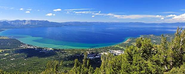
A panoramic view of Lake Tahoe, as seen above the South Shore.
Whether you call it Big Blue, the Lake of the Sky — or, as Mark Twain so famously wrote in his masterpiece Roughing It, “the fairest picture the whole earth affords” — one thing is for certain: We all are here because of Lake Tahoe.
But just how much do you know about this magical body of water and the Lake Tahoe Basin as a whole?
For example, did you know that scientists have determined the basin was formed by geologic block faulting about 2 to 3 million years ago?
“A geologic block fault is a fracture in the Earth’s crust causing blocks of land to move up or down,” according to the U.S. Geological Survey. “Uplifted blocks created the Carson Range on the east and the Sierra Nevada on the west. Down-dropped blocks created the Lake Tahoe Basin in between.”
From there, a combination of snow, rain and streams filled the southern and lowest part of the basin, forming the ancestral Lake Tahoe, according to the USGS, and modern Lake Tahoe was eventually shaped and landscaped by scouring glaciers during the Ice Age.
So there you have it. A deep history, indeed.
With that in mind, here are Tahoe Magazine’s Top 10 need-to-know numbers and fun facts about the greatest lake in the world, courtesy of staff research, historic reports and information published by the USGS.
1. A Long History: While the Lake Tahoe Basin had been occupied for centuries by members of the Washoe Tribe, the lake was “officially” discovered in 1844 by U.S. Gen. John C. Fremont.
2. What’s In A Name: By 1853, the lake’s official name was “Lake Bigler,” in honor of California Gov. John Bigler. The U.S. Department of the Interior introduced the name Tahoe in 1862, and both names were used until 1945, when the lake received its official and final designation as Lake Tahoe.
3. Golden State Dominates: The Lake Tahoe Basin is divided by the Nevada-California state line at Stateline on the South Shore and Crystal Bay to the north. Casinos at both shores make it clear where the state lines exist. About 1/3 of the basin lies in Nevada, with the other 2/3 in California.
4. Now That’s Deep: A maximum depth of 1,645 feet in Crystal Bay makes Tahoe the second deepest lake in the United States (behind Oregon’s Crater Lake at 1,949 feet) and the third deepest in North America (behind Great Slave Lake in Canada’s Northwest Territories at 2,015 feet).
5. High In The Sky: Lake Tahoe’s natural rim is at 6,223 feet in elevation, and the maximum legal limit is 6,229.1 feet. Since 1987, levels have fluctuated from 6,220.26 feet during the prolonged drought in 1992, to 6,229.39 feet during the flood of January 1997.
6. Record-Setting: As of late April 2017, Lake Tahoe’s water level hovered at 6,228 feet, the highest its been in years thanks to a record-setting 2016-17 winter in terms of snowfall. Water officials predict levels will breach the 6,299.1-foot legal limit by July 2017.
7. Perfect Peaks: About 78 percent of the basin is at altitudes from about 6,500 feet to greater than 10,000 feet. At 10,881 feet, Freel Peak is the tallest peak in the Lake Tahoe Basin. Jobs Sister is just behind at 10,823 feet, followed by Mt. Rose (10,778 feet) in third place.
8. A Big Footprint: The Lake Tahoe Basin is 506 square miles: The surface area of the lake is 192 square miles, and the watershed area is 314 square miles. To put it another way — Tahoe’s 192-square-mile surface area equates to 122,880 acres.
9. Cold Waters: Tahoe’s water temperature generally cools to 40-50 degrees in February and March and warms to 65-70 degrees in August and September. Below a depth of 600-700 feet, the temperature remains a constant 39 degrees. And nope, the lake does not freeze.
10. Taking Up Space: The length of Lake Tahoe is roughly 21 miles (north to south), and its width is 11.9 miles (east to west). The floor of the Lake Tahoe Basin is at an elevation of about 4,580 feet, which is lower than the surface of the Carson Valley to the east.

Comments
Use the comment form below to begin a discussion about this content.
Sign in to comment