This view from last week shows the distance between the V-line canal and the weir construction.
With the completion of a diversion structure or weir to allow water to flow into the desert from the V-line canal, the State of Nevada is closing U.S. 95 south between Pasture Road and Schurz today to reinforce and install additional culverts that will be used to protect the major north-south highway during local flood mitigation efforts.
Gov. Brian Sandoval announced Tuesday the highway will be closed through March 17 for Nevada Department of Transportation crews to reinforce the road before water reaches the area.
The Truckee Carson Irrigation District is expected to begin releasing water within the next two days from the V-line canal after construction crews from TCID, the county road department and out-of-state construction companies finish the main part of the project.
“The controlled release of floodwaters into Carson Lake is an important strategy to limit flooding for residents and businesses in Fallon,” Sandoval said in a prepared statement. “There are as many as 3,000 vehicles traveling this section of U.S. 95 every day, so it is important to do as much preventative work as possible to try and avoid significant flooding when the water is released from Lahontan Reservoir.”
Rusty Jardine, TCID’s district manager, said the section of the V-line being modified is familiar to TCID. In 1997 after similar heavy flooding, the irrigation district released water into a channel that snaked its way south of the canal and toward Sheckler Reservoir.
“The V-line is the mother of canals in this valley and divides into the other lines,” he said.
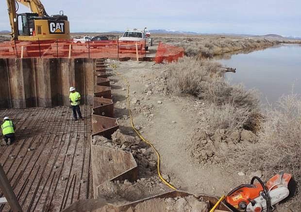
Six tractor-flatbed trucks dropped off the steel. Workers began driving 20-foot tall sheet pile or steel panels into the ground last week to create a weir structure, which in turn, will allow water to flow over a spillway and into a channel. About 120 yards of concrete cover the weir’s floor with a thickness of 1 foot.
On Wednesday, crews completed the project by cutting the steel sheet piles and completing the removal of the embankment, separating the structure from the canal. At that point TCID will increase the water flow into the V-line canal, and the water will then enter the spillway.
“The spillway will direct water into the channel and across the desert,” Jardine said, adding the elevation of water determines the rate of flow.
Until TCID reduced the V-line flow for workers to complete the project, the canal had been running at about 600 cubic feet per second.
Jardine said the Bureau of Reclamation designed the concept for the spillway, and the total cost of the project could reach a half-million dollars. Jardine said TCID would be able to apply for reimbursement.
Normally, a project of this size would take a year to approve and finish, but since it’s an emergency for potential flood mitigation, Jardine said the agencies moved quickly to approve and begin work on it.
Jardine said upward of 100,000 acre feet of water or more could flow into the desert and fill the smaller reservoirs such as Sheckler and then down to the U.S. Navy’s Bravo 16 range to U.S. 95.
Some of the water will reach the Carson Lake Sink and other natural land basins on both sides of U.S. 95. Jardine said floodwaters may surround the highway in the Carson Lake basin area through the spring and summer.
NDOT will install 12 six-foot-by-four-foot box drainage culverts to the existing 10 roadway culverts to help channel floodwaters underneath U.S. 95 to the Carson Lake sink. NDOT said improvements would also help reinforce the highway against potential flooding in future years.
Since flood waters and closures will affect the Navy, the commanding officer of Naval Air Station Fallon said hydrologists told him the water flow will have minimal impact on Bravo 16, which is used for SEALs training.
Capt. David Halloran said the Seabees are looking at constructing an alternate route to Bravo 16 in case floodwaters wipe out the main road. If the highway remains closed, he said the travel time to Bravo 19, another Navy range and small arms range, about 30 miles south of Fallon will require a two-hour one-way trip instead of the normal 30-minutes.
With Bravo 20 near the Stillwater Wildlife Refuge, he said additional water could render the existing targets unusable.
Halloran said the Navy has been working closely with state and local agencies and appreciates the work they have been doing.

Comments
Use the comment form below to begin a discussion about this content.
Sign in to comment