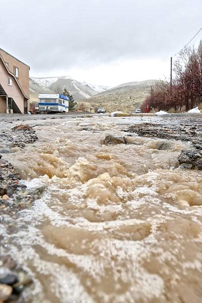
While not as bad as last year water is seen flowing hard again down Rhodes St. adjacent to the Greenhouse Garden Center Thursday afternoon.
Though Carson City will see some heavy precipitation, city officials say there is no concern of major flooding.
City department directors have been meeting periodically since Wednesday to make sure everything is all right in light of rainfall, said Emergency Manager Stacey Belt. She said the Carson River has yet to reach the 8-foot stage they begin monitoring for flood coverage — let alone the 10 feet it needs to reach for the lower range flood stage.
“We are guessing we will have rain throughout the evening, in addition to the snow melt from Lake Tahoe, so we will continue monitoring it,” Belt said.
However, she said the city doesn’t anticipate activating the Emergency Management Operations for any major flooding like they had to do last year. Likely, it will just be wet spots and possible dirt flooding but nothing like what Carson saw last year, Belt said.
Meteorologists with the National Weather Service said as of mid-Thursday, Carson City saw about 1.2 to 1.4 inches of precipitation fall in 24 hours.
Some minor flooding may be seen along creek and stream beds, but no flooding on the main river. A flood advisory was in effect until 4 p.m. Thursday.
As a precaution, Public Works placed sandbags at Kings Canyon, but that is the extent of flood preparation.
Some flood plains, such as the intersection of Little and Roop and the NorthTown Plaza, around Carson City have seen some flooded spots, but nothing to cause concern. Sandbag fill stations have been set up at Winnie Lane and Foothill Drive, Fire Station 52 at 2400 College Parkway, 3505 Butti Way and 280 Appion Way.
If drivers on the road do experience flood conditions, use caution and don’t drive through it.
Tahoe, however has been hit hard with the winter storm, as an avalanche closed Mount Rose Highway Thursday morning. About 8 inches of snow collected in a 10-minute period in some areas which caused Nevada Highway Patrol to close the highway down indefinitely, said public information officer Matt McLaughlin.
The highway was closed from the summit to the entrance of Mount Rose Ski Tahoe, with the avalanche occurring on the highway near mile marker 9.
One vehicle was hit in the avalanche, but no injuries were reported.
Weather conditions in the Sierras were expected to deteriorate through Thursday. The National Weather Service Reno issued a dangerous snow squall for the Sierras on Thursday afternoon, expecting snowfall rates of 2 to 4 inches per hour and near zero visibility in some areas of the mountains for several hours.
The squalls were also expected to hit parts of Minden, Douglas County and western Carson City.
However, for Carson, residents can expect a small break in the weather come Friday. Meteorologists with the National Weather Service Reno said that Carson saw intense precipitation throughout Thursday, but will stop raining Friday before turning into snow showers Saturday morning.
There is also a possibility of snow showers Saturday night into Sunday, which could result in about half an inch of accumulation, but nothing like what the region experienced last week, said meteorologist Zach Tolby.
For information on Carson City flood conditions, visit carson.org.

Comments
Use the comment form below to begin a discussion about this content.
Sign in to comment