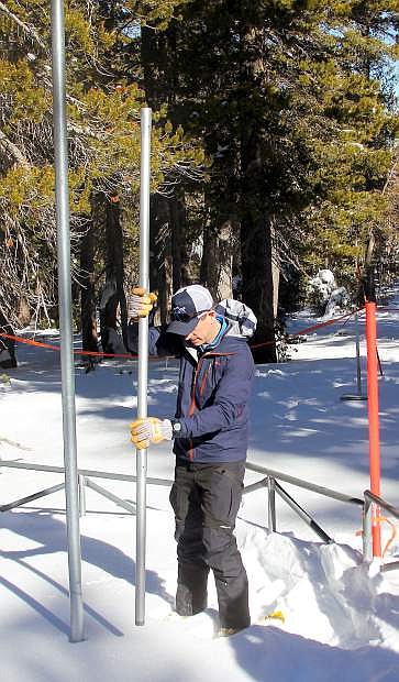
Natural Resources Conservation Service hydrologist Jeff Anderson measures the snowpack Wednesday at Mt. Rose Ski Tahoe.
MOUNT ROSE, Nev. — And the survey says … the Lake Tahoe Basin snowpack is light, but mostly better than last year.
The first survey of 2019 revealed the basin snowpack is below normal, especially on the North and East shores of Lake Tahoe with the Mount Rose SNOTEL site at 57 percent of median for the season.
Natural Resources Conservation Service hydrologist Jeff Anderson took four samples Wednesday, Jan. 2, from the “snow pillow” that measured the snow level being 30 inches deep at 8,800 feet.
“It’s not very good, 57 percent is not good on a report card — it’s a failing grade,” Anderson said. “We’re not quite where we want to be, but the snowpack overall is much better than last year. The East and North shores have missed some of the storms that have come through.”
The survey came days before a winter storm warning is set to take effect in the greater Lake Tahoe region. According to the National Weather Service in Reno, the lake could see 6 - 13 inches of new snow between Friday night and Sunday morning. Snow totals above 7,000 feet could range from 12 - 22 inches.
Despite the forecast, Anderson said it is unlikely to make a big impact.
“We expect snowstorms to come every week in January,” Anderson said. “If we don’t get consistent storms, our snowpack will rapidly decline.”
Cold storms early this season have given the basin a much different look than at this time last year when the storms came, but were warm in nature and only mountaintops were covered in white.
The Mount Rose area had a deeper snow depth last year (35 inches), was at 80 percent of median and was enjoying the most snow in the basin. At the same time, lower elevations were bare with most of those storms delivering rain at lake level.
This year, the crest on the West and South shores has received a little more snow and are just below average with the Carson Pass area at 94 percent. Last year Carson was at 49 percent.
Kirkwood Mountain Resort remains the only ski and riding area 100 percent open with Sierra-at-Tahoe nearly there.
“This area does not reflect other areas which are close or above normal, so it’s a little misleading,” Anderson said. “But we’re still very early, about one-third of the way through the snow season.”
The Lake Tahoe and Truckee basins are lagging well behind other areas in Nevada with the Northern Great Basin and Carson, Walker and Lower Humboldt basins to the east are at, or above average, for the season, according to a snowpack map provided by Anderson.
To measure the snowpack, Anderson sticks a long, hollow stainless-steel metal pole into the snow that measures the depth and also collects snow where it is weighed to supply the water content.
The SNOTEL site also provides digital data by using a bladder filled with an anti-freeze solution that measures the weight under the “snow pillow.”
Anderson was there Wednesday to confirm what the site has been reporting.
Since Oct. 1, precipitation is well below normal in the Eastern Sierra. The fall rainstorms mostly stayed away and the soil under the snow is drier than normal.
The reservoirs are also a little lower than a year ago with Lake Tahoe at 61 percent of capacity as opposed to 78 percent last year at this time.
The Truckee Basin reservoirs (Donner, Independence, Stampede, Boca and Prosser) are at 69 percent capacity. They were at 81 percent last year.
Last year the snowpack and winter season were salvaged at the final hour, or month.
“March was really an amazing month, that got us back to a decent snowpack,” Anderson said.

Comments
Use the comment form below to begin a discussion about this content.
Sign in to comment