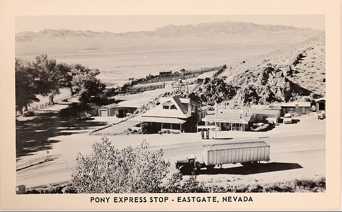
Image of Eastgate Station from the 1950s, before the re-routing of U.S. 50 dried up any road traffic on the route.
In central Nevada, the small settlement of Middlegate gets plenty of attention. As home of the Middlegate Station, a bar and restaurant famed for its hamburgers, and location near the famous Shoe Tree II, Middlegate is definitely on the map for Highway 50 travelers.
But another place with a similar name, Eastgate, is often all but overlooked. Part of the reason is that Eastgate is located on what is sometimes called “Old U.S. 50” or the Carroll Summit Route, a road (now known as State Route 722) that parallels the current highway between Middlegate and Austin.
In the 1960s, when the present-day U.S. 50 was constructed to shorten the highway and eliminate the steep climb over Carroll Summit, much of the traffic on Old U.S. 50 disappeared.
One of the casualties of that re-routing was Eastgate, located about 47 miles east of Fallon via U.S. 50 and (at a point 4.5 miles east of the junction with U.S. 50) SR 722.
While long a campsite for the native people of Nevada, the first mention of the area appears in explorer Capt. James H. Simpson’s “Report of Explorations Across the Great Basin in 1859.”
Simpson, who led a mapping expedition across Nevada that year, named the area Gibraltar’s Gate after a large rock formation that overlooks it, which he had named Gibraltar (after the famous rock). He named an adjacent canyon Gibraltar Canyon.
Simpson also provided names to Middlegate and another location, Westgate, after other rock outcroppings. Eventually, the Gibraltar name disappeared as it was commonly referred to as Eastgate for being the most eastern of the three gates.
Part of the reason Eastgate had been a camping area for the Shoshone was the presence of a small stream at the mouth of the canyon. In about 1870, a small vegetable farm and freight station (for the Overland Stage) was established at Eastgate.
In the late 1870s, a man named George B. Williams acquired the station and ranch, and built a small, white stone house (made from local tufa). In 1908, a larger white stone house (still standing) was erected at Eastgate, which, following the completion of the Lincoln Highway, sported a store and gas station (and eventually a restaurant).
Throughout the early to mid-20th century, Eastgate served as a welcome stop for auto travelers on U.S. 50.
All, however, came to an end by the late 1960s with the re-routing of U.S. 50. Nevada writer David Toll writes in his popular Nevadagram blog (www.nevadagram) that another factor in the ultimate demise of the Eastgate ranch was the 1954 Fairview Earthquake.
According to Toll, the 7.3-magnitude quake not only shook the ground and raised up portions of the desert floor by several feet, but it also shifted the flow of the natural springs, including the stream at Eastgate. Without a reliable water supply, the area’s was no longer viable for agriculture.
Today, the large white stone house and a handful of smaller buildings that appear abandoned are all that mark Eastgate. They remain private property, so it’s best to check it out or take photos from the road and not trespass.
Eastgate’s other claim to notoriety is as the location of Wagon Jack Shelter and Eastgate Cave. These two sites were extensively studied by archaeologists in the late 1950s, who uncovered indications of early Native American activity.
According to archaeologists Richard Heizer and M.A. Baumhoff, who investigated the area in the late 1950s, use of Wagon Jack Shelter (named for a Shoshone leader who once led rabbit drives in the area) dates back 1,500 years. Excavations of the shelter produced a wide variety of different projectile points (arrow or spear heads).
Eastgate Cave, located about 200 yards southeast of the shelter, dated to about the same time and, according to scientists, served as a cache where hunting snares and other objects could be stored.
For information on Eastgate, check out David Toll’s blog on the three gates, https://nevadagram.com/three-nevada-gates/ or Stanley Paher’s classic book, “Nevada Ghost Towns and Mining Camps.”
Rich Moreno writes about the places and people that make Nevada special.

Comments
Use the comment form below to begin a discussion about this content.
Sign in to comment