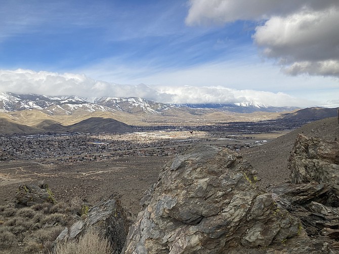
Prison Hill is a favorite in Carson City year-round. The trails range from easy to difficult. There are sights to see and a cool canyon to hike through (with an old truck that got stuck). Newer paths were completed in December 2020 connecting several trails making it easy to hike a loop. Prison Hill has a desert landscape, with plenty of sagebrush, thistlebrush and rabbitbrush covering the 2,500-acre recreation area. Besides a few bushier trees at the north end of the hill, there’s almost no shade along the hike unless you’re sitting next to large rocks. Beware of rattlesnakes once the weather heats up. Stay on trail and you should have no problems with them. Also if you’re going to hike closer to dark, beware of coyotes. From higher up, you have views all along the Sierra Nevada, and you can see to the north as far as Slide Mountain. You can see all of Carson City from the west side of the hill and the other side has a valley view. The highest point of Prison Hill is 5,724 feet (this spot is located along the Escape From Prison Hill trail). The southern end is reserved for offroad vehicles. The northern end is popular for hikers, bicycles and equestrian use. Prison Hill is also right near the Mexican Ditch and Silver Saddle Ranch. Read about those trails here: https://bit.ly/3rJhVfl TRAILHEADS There are four different places to park around Prison Hill. There are maps at every parking trailhead and the trails are well distinguished. From the North, there’s the corner of Fifth Street and Carson River Road. The North Loop Connector Trailhead is here. From the east, there’s Silver Saddle Ranch. Park here if you want to go up Dead Truck Canyon. On the west side there’s two parking areas. On Koontz Lane you can get on the North Loop and the West Loop. And on Clearview Drive there is a spot to get on the West Loop. EASIER TRAILS The North End of Prison Hill by Fifth Street has grown in popularity after the completion of Prison Hill Trail East (1.6 miles). With an expanded parking lot, there’s also a bathroom and a picnic table with some shade. Prison Hill Trail East runs along Carson River Road and you’ll see someone walking or biking this trail almost any part of the day. It’s a wide path on decomposed granite and it connects to the parking area at Silver Saddle Ranch, so you can continue along the Mexican Ditch trail or go up the hill from here for a long loop. The north end includes three small loops: Sagebrush Loop (0.75 miles), Rabbitbrush Loop (0.5 miles), and Bitterbrush loop (0.4 miles). These three loops have a gradual elevation gain but nothing too strenuous. You’ll get enough elevation for a decent view of the surrounding area. There are a few interpretive signs along the way giving lessons about the type of plants growing right in front of you. HARDER TRAILS Going up the hill is about 800 feet of elevation gain, depending on which trail you take. The North Loop Connector Trail is 2.1 miles; North Loop is 3.8 miles; West Loop is 2.5 miles and Dead Truck Canyon is 1.7 miles one way. The trail surface going up these hikes starts sandy at the base of the hill then they get rockier and follow some older roads, so it is not always a smooth path. Once you get to the top, the rock formations are interesting to see and there might be some bird activity on the right day. LONGER ROUTES There is one long trail that will take you all over the hill and it’s used for half-marathons. The Escape from Prison Hill Route is 12.7 miles. This trail runs along most of the ones mentioned before, and also reaches the highest point in the area and borders the off-road section. Another loop that takes about 6 to 7 miles is Dead Truck Canyon to the North Loop, which joins the Connector Trail, and the new Prison Hill Trail East leads from here back to that parking area. Check out the routes on a map here: https://bit.ly/3mn8q4n. Always remember to respect nature and other hikers. Leave no trace and take everything you brought in back with you. Kyler Klix is a designer for Nevada News Group. He also writes about the outdoors and entertainment. Email him at kklix@nevadanewsgroup.com.
Comments
Use the comment form below to begin a discussion about this content.

Comments
Use the comment form below to begin a discussion about this content.
Sign in to comment