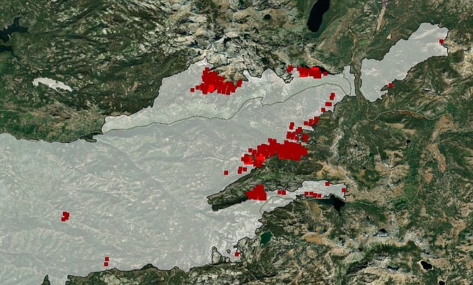
The head of the Caldor Fire bear shows some heat in places around the perimeter 6 a.m. Wednesday in this Fire Information for Resource Management System’s virtual map.
It helps to visualize the Caldor Fire as a bear smoking a cigar when discussing where it’s burning.
As of 6 a.m. Wednesday, much of the cigar has been stubbed out, while fire continues to burn on the left side of its head, on the right side of its neck and along both its front legs.
Hand and dozer line is connecting with the granite near the southeast side of the cigarette and the fire there appears to be winding down, according to Fire Information for Resource Management System’s virtual map on Wednesday morning.
Attaining 50 percent containment on Tuesday, the fire isn’t out by a longshot. As of Wednesday morning, the fire had grown 923 acres to 217,569 acres over the previous 24 hours.
Satellite mapping isn’t an alternative to what’s visible on the ground.
The AlertWildfire.org camera at Heavenly is showing a little bit of flame this morning, but it’s far less widespread. The Hawkins Peak camera shows the fire burning on the other side of the ridgeline, as do the Sierra at Tahoe and Leek Springs cameras.
Highway 50 has reopened between the Y at South Lake Tahoe and Meyers Highway 89 is closed from Meyers to Highway 88 at Picketts Junction in Hope Valley. Highway 88 is closed from Hope Valley to west of Mormon Emigrant Trail.

Comments
Use the comment form below to begin a discussion about this content.
Sign in to comment