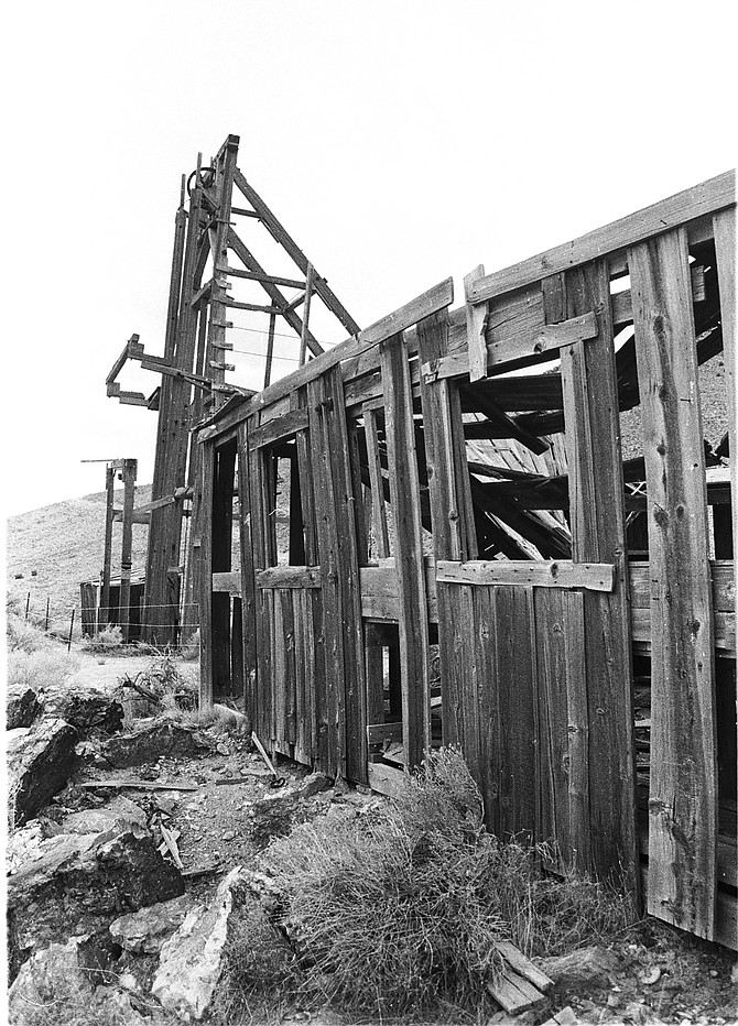
Picturesque ruins such as these can still be found in the ghost town of Rochester.
It’s difficult to believe that about a century ago, a nearly continuous string of mining camp structures once stretched for more than two miles through Rochester Canyon, which is located about 10 miles southeast of Interstate 80 at the Oreana exit.
To reach the site, exit at Oreana (14 miles northeast of Lovelock), then travel three miles on a paved road. At a fork in the road, turn right onto a maintained dirt road and continue another seven miles to Lower Rochester.
In the early part of the 20th century, Rochester Canyon was one of north-central Nevada’s most successful mining camps, producing more than $6 million in silver, gold, copper, and lead.
Prospectors from Rochester, New York, (hence its name) first explored Rochester Canyon in the early 1860s. Small-scale mining was initiated but proved largely unsuccessful.
In 1912, a man named Joseph Nenzel discovered large bodies of silver ore in the canyon, which sparked another, far more significant boom. By 1913, more than 2,000 miners were working the area and an impressive ribbon of miner's shacks, commercial businesses and other buildings lined the center of the canyon.
Several separate town sites were actually laid out in the canyon. Near the top was Rochester Heights, which had a popular local saloon. Farther down the canyon was upper Rochester, (also sometimes called, simply, Rochester), which quickly became the largest settlement with several substantial stone buildings to house hotels, saloons, and offices. At the mouth of the canyon was lower Rochester.
At its peak in 1913-14, the town of Rochester had its own orchestra, regular freight service, dance halls and a 100-ton mill to process the ore.
By 1915, following completion of a short line railroad that connected to the nearby Southern Pacific line, lower Rochester grew into the biggest camp. In 1917, an aerial tram system was completed to carry ore from the mines to the mill at lower Rochester.
Rochester’s mines continued to be productive throughout the 1920s and 30s. The mines were shut down in 1942, as a result of shortages of equipment and supplies during the Second World War. Efforts to restart the mines continued after the war but none succeeded until the 1980s with the development of a large gold mining operation, the Coeur Rochester Mine. Located on the mountain above the canyon, those mining operations continue today.
Despite the years of neglect, Rochester, as the whole area is generally referred to today, offers intriguing glimpses at an early 20th century mining camp. When you enter the former site of lower Rochester, you will find a handful of impressive wooden mining headframes and decayed buildings on the southern hillside.
Wandering among the ruins, you can spot the mostly intact flywheels, cabling, and other pieces of equipment on the headframes. Additionally, there are also the partial remains of the ore-cart track and bridge, adjacent to the headframes and buildings.
One note of caution: be very careful walking around any part of Rochester Canyon because there are many open mine shafts. Also, do not touch anything. Most of the buildings are barely standing and probably won’t survive too many more years and any abuse.
A little farther up the canyon from those ruins, you will find a large structure, the former Buck & Charley Mill, which is still mostly intact. The building seems in fairly good condition, although not safe enough to enter. Opposite the mill building, you can also spot the large concrete foundations of what must have been another, larger mill site.
The road continues up the canyon, with a handful of stone foundations and crumbling, wooden miner’s shacks peeking through the surrounding sagebrush. A commemorative plaque telling the story of Rochester can be found in front of one of the former miner’s homes, adjacent to the road.
From the plaque, the road heads farther up the canyon but it’s not open to the public, being the property of the Coeur Rochester Mine. The site of upper Rochester is buried under the massive tailing piles of the newer mining operations.

Comments
Use the comment form below to begin a discussion about this content.
Sign in to comment