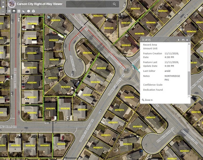
A graphic provided by Carson City Transportation Division showing GIS mapping software. The gray shaded areas depict city right of way. When the area is selected, a dialog box opens and displays a description of the right of way and a link to relevant documents.
Carson City transportation officials are developing a comprehensive GIS map of the city’s right of way to better understand ownership and maintenance needs.
“From a transportation perspective, this project is important because the city needs to understand what it owns and how it was obtained,” said Transportation Manager Chris Martinovich. “It takes a long time to search through and piece together individual documents. A mapping system simplifies this. It is important for not only federal right of way certification, but also to understand maintenance responsibilities, and to streamline document tracking and research.”
Since the project was started in 2019, about 34 percent of city right of way has been mapped. Farr West Engineering was originally hired for the project but has since merged with DOWL Engineering.
“About 104 centerline miles of road have been mapped so far,” Martinovich said. “Several other roads have been started, but not fully mapped. … This contract is an on-call project, meaning DOWL completes the work when asked to do a specific task. The on-call contract has a not-to-exceed amount of $49,000. I don’t anticipate we will reach the full amount this year.”
Once the digital map is finished, city staff will be able to pull up a section of right of way and see relevant information and documentation.
Martinovich said the mapping site will not be publicly available.
“Residents can view their parcel information using the city’s MapGeo site or by doing a records search through the Carson City Recorder’s Office,” he said.
The public GIS map can be accessed through the assessor’s website: https://www.carson.org/government/departments-a-f/assessor/gis-public-site.
Some challenges lie ahead for the right of way mapping project: overlapping or missing documents and old files dating to before Carson City was consolidated with Ormsby County in 1969.
“Federal right of way certification is a documentation process required by (Nevada Department of Transportation) and the (Federal Highway Administration) on all federally-funded projects,” Martinovich said. “The city has to ‘certify’ it owns what it says it owns and has to provide the documentation in support. This research can be very time consuming for staff. The right of way mapping project will streamline the federal right of way certification process by consolidating all documentation for a given segment of road.”
The right of way map is being developed at the same city time transportation staff members are working on an “access management plan.”
According to a staff report presented to the Regional Transportation Commission, this plan will be based on city code and best practices of other transportation agencies. It will provide guidelines for driveways, entrances and exits, turn lanes and medians, ensuring appropriate spacing and design. It will also have a right of way element.
“The two projects are indirectly related,” said Martinovich. “Understanding a roadway’s right of way ensures that driveways and intersections are positioned with sufficient sight distance, so they are safe to use.”

Comments
Use the comment form below to begin a discussion about this content.
Sign in to comment