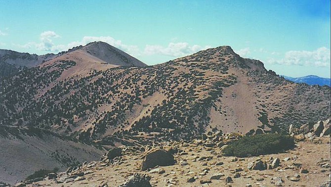
Pat Devereux/Nevada Appeal Jobs Sister, foreground, and Freel Peak are seen from the summit of Jobs Peak.
You've seen them a thousand times, the three 10,000-plus-foot peaks of Freel, Jobs and Jobs Sister, bathed in the alpenglow of a summer sunset or impossibly bright and shining against the cold winter sun.
You've heard you can climb Jobs and Freel on straight-up, arduous trails from Carson Valley and Lake Tahoe, respectively. But is there an easier way - and how the heck do you access Jobs Sister?
My Stagecoach neighbor, the intrepid T A, leads a Sierra Club hike each September on which we climb all three peaks in one day, traversing saddle-to-saddle. The total gain is 4,400 feet, with an altitude loss total pretty close to that, I'd guess, in 10 miles. A long day, for sure, but few folks can claim to have summited Jobs - let alone its Sister and Freel, all in one day.
On Sept. 16, seven of us headed up Highway 88 to Highway 89 and the Horse Meadows turn-off. We drove to the parking area and suited up, bringing extra layers for anticipated high winds on the peaks.
We crossed Willow Creek and went up a steep, sandy hill to a log deck. Look for the "Closed to Motor Vehicles" sign on the far side to continue.
The trail crosses a small creek then begins switchbacks under Jeffrey and lodgepole pines full of mountain chickadees and Clark's nutcrackers. Soon we reached an intersection with signs for Star Lake and the Tahoe Rim Trail; go right, up the hill.
The trail became a mile-long traverse along the back side of a ridge, with rock spires above and ahead. Views of the backside of Desolation Wilderness included Tallac, Dicks and Pyramid peaks. We saw the last of the summer wildflowers: sulfur flower, lupine, shriveled wyethia, pennyroyal and rabbitbrush. Rounding the mountain, we spied Christmas Valley and the South Lake Tahoe airport and vehicles on Highway 50 headed for Echo Summit.
Two long switchbacks brought us to a saddle, with the first of several signs identifying the region as a "sensitive plant area" because of the endangered Tahoe draba. We admired the views of Tahoe and Tallac, and picked out the runs on the backside of Heavenly Mountain Resort. We left the Rim Trail and went right up the trail signed "Freel Peak 1 mile."
Switchbacks and rock steps took us up the now-treeless backside of Freel, beyond the boundary sign for Mokelumne Wilderness. We could see the Tahoe Keys paddle-wheeler heading in to port, Fallen Leaf Lake and our first glimpses of Carson Valley. T A grinned and pronounced, "Elevation is its own reward."
At the top, we signed the peak register at the base of the "Freel Peak 10,881'" sign. The trail between the saddles of Jobs Sister and Jobs peaks was clearly visible, and we comprehended how much elevation we must soon lose - and gain.
It was a quick drop to the rocky saddle between Freel and Sister. The trail became indistinct, but you can't miss if you just head into the gaps of the scrubby, weather-beaten conifers, after which it becomes evident again.
We traversed on switchbacks up the back of Sister, and ate a quick lunch and took photos of ourselves with the "Jobs Sister 10,832'" sign with Tallac and most of Tahoe in the background. We could see vast sections of the Valley and pretty Star Lake far below.
Two down, one to go ...
Now came the most difficult part of the trail: a very steep, half-mile drop on small rocks and decomposed granite. I bent my knees and was happy for my hiking pole. At the treed saddle, T A and I (as the only ones who'd done the hike) discussed the need to stay high so as to not lose elevation heading for Jobs.
Many faint trails converge, so we traversed from one to the other, always heading up, to a definite trail along the back of the ridge. A few more switchbacks up the back of Jobs, and we were on top, with a stunning 360-degree view of Lake Tahoe, the Carson Valley, the Pine Nut Mountains and even Dayton Valley. The sign at the top read, "Jobs Peak 10,633."
From there, it was the proverbial all downhill. We dropped back down to the trail leading to the Jobs/Sister saddle. Keep an eye out for a dip in the upper part of the saddle, about half a mile from Jobs' summit. Ducks, or cairns, indicate a distinct trail dropping off the back toward Hope Valley. Over about a half mile, we counted two gullies then turned downhill into the third; for the first time, it was marked by a duct-tape-wrapped log, but you might not be so lucky. Miss this turn, and you'll end up miles from your vehicle.
More ducts quickly let us know we were on the right trail. Traversing downhill with views of a huge bowl at the back of Jobs, the trail became a four-wheel-drive road. It forked twice, and we were careful to always veer right, eventually coming to the parking area for Horse Meadows. After about a mile total on the road, we came upon the vehicles.
• Pat Devereux is the Appeal copy desk chief. Contact pdevereux@nevadaappeal.com or 881-1224.
If you go
WHERE: To find the Horse Meadows trailhead, take Highway 88 to its junction at Hope Valley with Highway 89, heading to Luther Pass. Go 2.2 miles (there's a turnout opposite the turn) and turn right on U.S. Forest Service Road 051, with its large brown access sign. High-clearance 4WD vehicles are required. Ignore the many turnouts and stay on the best-traveled road. Go approximately 2.5 miles, crossing a bridge after two miles. Immediately after the second bridge, park in the wide spot and head up the trail over a creek on an abandoned vehicle bridge
WHEN: Late summer/early fall because of snow
DIFFICULTY: Strenuous; expect the hike to take about eight hours
MAP: El Dorado National Forest

Comments
Use the comment form below to begin a discussion about this content.
Sign in to comment