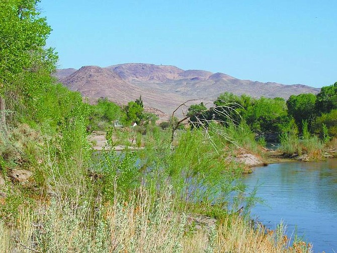
photo by pat devereux/Nevada Appeal The Carson River along the Buckland Station trail is very low this year, after scant spring rains.
While driving down Alternate 95 past Fort Churchill State Park, have you wondered about that big, old white house just before you cross the Carson River? It is the former home of Samuel Buckland, Nevada pioneer.
The house serves as the trailhead of a pleasant stroll along the river, on which you can also double back over the route of the Pony Express.
Buckland came to Nevada in the mid-19th century. He started out as a rancher, but then landed the lucrative contract for supplying nearby Fort Churchill and the Express riders with foodstuffs.
The big white house became a way station for the riders and weary pioneers, and the long-gone settlement of Weeks grew up around it. At the trailhead, you can peer through the lace curtains of the home and read all about Sam Buckland. Then cross the bridge, hop the guardrail, and look for the green gate iron of the trail's start.
Signs along the way give the mileage to various points of entry. In a high-water year and early spring, this trail can be inundated. This spring, however, the water is low and the sandy path bone dry.
In the shade of big cottonwoods, you walk along the river, looking for ducks, great blue herons and Canada geese out on the water. The calls of red-tailed hawks, magpies, wrens, mourning doves, black-headed grosbeaks and song sparrows abound. Listen, too, for the rhythmic canary-chirps of a bald eagle or osprey.
Interpretive signs along the way discuss the native plants you pass. After about 11Ú2 miles, you come to the Boy Scout Campground, with its picturesque wooden corral and many horse trailers. There are steps leading down to the water and an eddy for swimming.
After another half-mile near the water, the trail veers inland under dense cottonwoods providing welcome shade. It then comes out on a backwash by a meadow filled with balefully staring cows and nice views of the desert hills.
Look up to the right, and you will see a bluff with a wooden rail and barbed-wire fence. The trail gets a bit faint here, but just head for the point. You will go through a green, iron Bureau of Land Management gate with a trail map. The picnic table here is a good lunch spot.
You are now about 31Ú2 miles out.
At this point, you can retrace your steps or return via the road by the table. It leads back to the river at the signed Boy Scout Campground.
Or, if you want to add another half mile, you can take the Pony Express road back.
Go due west cross-country, counting the roads that you cross, starting with the one by the table. Stop at road No. 7, and turn right back toward Alt 95. Soon you will see Pony Express route markers - sadly, they are flat on the dirt, shot full of bullet holes and run over by redneck jerks.
You will pass an old corral as the road veers gradually back toward the river. The road comes out on a frontage path beside Alt 95. Turn right, and shortly you will see the iron gate through which you accessed the river trail.
• Contact Pat Devereux at patd@nevadaappeal.com.
If you go:
WHAT: Buckland Station hike
DISTANCE: Approximately eight miles round trip.
WHERE: Take Highway 50 East to Silver Springs. Turn right at the intersection on Alternate 95. Go about 10 miles to the Fort Churchill State Park sign. Pass this for another mile or so then look for the big white house on the left, just before the bridge over the Carson River. Turn left into the parking lot.

Comments
Use the comment form below to begin a discussion about this content.
Sign in to comment