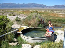
Jeff Moser/Submitted PhotoCharlie Moser tests the water at Spencer Hot Springs in Big Smokey Valley. Tubs are set up with movable pipes to allow you to customize the water temperature.
Summer is winding down, making it a great time to explore and bike the high desert of central Nevada. Daytime temperatures are comfortable, and the nights are still warm enough for tent camping. We took advantage of the long Labor Day weekend, and visited many locations in the mountain ranges near Austin.
Running late as usual, we left Carson City in the early Saturday afternoon and made our way east to Berlin-Ichthyosaur State Park.
We paused briefly in Fallon for some ice cream, and then stretched our legs at Middlegate, the turn off for State Route 361. The little outpost at Middlegate may be your last chance for any emergency items before reaching the State Park.
Gabbs is farther down 361, but not directly on the route to the park.
We made the final turnoff for the State Park on State Route 844, which eventually becomes a dirt road. It was just about time for dinner when we arrived at the campsite on one of the busiest camping weekends of the year.
As we drove through, we watched someone else pull into the last of the 14 campsites! Luckily they had an overflow area setup for the weekend, and we drove back to check it out.
To our surprise, we got to camp right next to a historical cabin in the picnic area. Dr. Camp occupied this cabin in the 1950s when he worked on the Ichthyosaur fossil dig.
It was dark by the time we ate dinner, but we were treated to a full moon soon after. After we retired for the night, I was awakened periodically by sounds coming from the cabins.
The big dog and I would look at each other after hearing the sounds of the rocks and bricks surrounding the cabin tumble around. I finally convinced myself that the underside of the cabin must be home to small nocturnal mammals, and went back to sleep.
The next morning we explored the park. Berlin-Ichthyosaur State Park contains one of North America's most abundant concentration of Ichthyosaur fossils, and also the well preserved turn-of-the-20th century mining town of Berlin.
We took a guided tour of the fossil shelter, and later freely walked around the ghost town. Many of the houses are decorated with period artifacts, so it's fun to peer through the windows and imagine how life may have been.
Both the fossil shelter and the town of Berlin are short distances from the campground, and would make fun family bike rides to either destination.
Union canyon climbs into the mountains to the east for further mountain bike exploration.
After exploring the state park, we headed north for Ione, population 41. We only saw one person out and about, but it was a Sunday. Many people who have explored Ione come back with stories of the people they've met there, and the interesting stories they tell. I think they like visitors.
We passed on the spirits, vittles, and gas at the Ore House Saloon, and headed east through the Shoshone mountain range.
We came out the east side of the mountains into the Reese River Valley. The road through the valley is dirt, but is nicer than some of the paved roads in Carson City. Interesting rock formations and canyons beg to be explored along the route if you have the time.
The Reese River, no more than a creek in most spots, has a Nevada legend attached to it. The story goes that the fraudulent Reese River Navigation Company sold stock shares to capitalize a fleet of barges to serve the mines in the Austin area.
You'd be lucky to get a raft down the creek, let alone a loaded barge. The merits of this story are up for debate however ...
The Reese River Valley is also home to the Yomba Indian Reservation. Old ranches line the grassy valley along the route, with plenty of evidence of a simpler way of life.
I bet that stories of celebrity scandals seldom reach these parts.
We eventually crossed the valley and approached the west side of the Toiyabe range. Not too far from Highway 50 is the Big Creek Campground.
It's a nice little campground along the creek, and a dirt road continues from the campground all the way through the mountains to Kingston and to the Big Smokey Valley beyond.
Just as we got to Austin, we took Castle Road back to the south. Less than a mile up the road is Stokes Castle, a must see if you're in the area.
The small mountain town of Austin has a welcome feel to it, and even has a couple of billboards advertising it as a central hub for mountain bike exploring.
Austin is also where you'll want to restock your supplies, get gas, or make a phone call. Gas is expensive here, but you may not find it again for a long way in any direction.
Just east of Austin is the Bob Scott Summit campground. It's currently free, but there are signs posted that it will go up to $10 in 2010.
Even at $10 it's still a bargain with running water and actual flushing toilets! We almost camped here, but the best sites were taken.
The wind was also starting to pick up at this campsite at 7,195 feet elevation, and the available sites didn't have much shelter.
We decided to head south to Kingston Canyon.
If you're into fishing, check out Kingston Canyon. Kingston Creek and Groves Lake, a wide spot in the creek, are well stocked and popular with the anglers.
From the Kingston Creek campground, you can ride all the way through the Toiyabe mountain range back to the Big Creek area mentioned above.
We had a nice campsite in the shade of the trees not far from the creek. It was noticeably colder on this side of the mountains in the early morning, so make sure you have warm clothes with you.
The Kingston Canyon campsite is free, but there is no running water. Bring what you need. We saw a General Store in the small town of Kingston, but I didn't see any signs of gas pumps in the area.
Spencer Hot Springs makes a nice side trip if you're east of the Toiyabe range in Big Smokey Valley. Less than a mile on State Route 376 off of Highway 50, there is a dirt road heading east across the valley toward Toquima Cave.
If you take this dirt road about 5 miles out, you'll cross under the power lines. Take the next left, and drive a short distance to jeep roads taking off to the north. Follow the jeep roads just over the rise to Spencer Hot Springs.
Tubs are set up with movable pipes to allow you to customize the water temperature. It makes a great place to clean up after a couple days of camping!
On the way home to Carson City I was taking notes along Highway 50. In the spring of 2010, I'd like to ride across Nevada, so I was interested in the location of water sources, how steep the mountain passes were, good campsites, location of the rumble strips etc.
My plan is for a supported ride, taking turns in the support car if need be. We'd all ride back in the car after the adventure was over.
If you're interested in joining me on this adventure, let me know.
• To read more, go to bikecarson.com.
• Don't pass up opportunities to get gas. The distances between gas stations is great, so top off when you get the chance. You will probably find yourself straying off the planned route as you find new places to explore along the way, so you don't want your gas tank to limit you. AAA doesn't do you much good when there is no phone service.
• As I just mentioned, phone service is spotty at best. About the only place we had service was in places along the Highway 50 corridor, and in the towns we visited.
• Let someone know where you're going before heading out.
• Pack your own water. Some of the campsites you encounter are quite primitive, and not all have running water. It's best to check the State Parks and Forest Service websites before heading out.
•Bring clothes and sleeping gear for a wide range of temperatures. It can get pretty hot during the day, and very chilly early in the morning before the sun come up.
• Good maps are a necessity. A Nevada DOT Highway Map is good for the major roads, but you may want maps with more detail if you plan on finding points of interest along the way.

Comments
Use the comment form below to begin a discussion about this content.
Sign in to comment