A wildland fire burned more than 4,500 acres almost one year ago east of Fallon.
A lightning-caused fire that ignited a fire in the Desatoya Mountain Range east of Fallon has grown to more than 4,000 acres as of Monday afternoon.
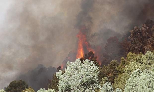
The Cold Springs Fire, which is 10 percent contained, is burning in thick vegetation and steep, inaccessible terrain about 65 miles east of Fallon. BLM officials located near the fire said gusty winds on Saturday afternoon fanned the blaze from 100 to 2,500 acres. The fire is located 15 miles east of U.S. Highway 50 just north of State Route 722. The two-lane Carroll Summit Highway is a secondary route to the Reese River Valley and Austin. At times the fire crossed the highway.
“This is the largest fire of the year the Carson City District,” said Lisa Ross, BLM public information officer.
She said a Nevada Type 3 Incident Management Team from the Sierra Front took over fire operations at 6 a.m. Monday.
She said the fire is consuming juniper trees and grass as air and ground crews are actively engaged in fire suppression activities. Ross also said the fire has burned some areas of sage grouse habitat and is threatening a Priority Habitat Management Area.
“The fire is actively burning within Nevada Department of Wildlife Hunt Unit 184 in the lower central section of the Desatoya Mountain Range,” she added.
In addition to BLM crews fighting the fire, the Nevada Division of Forestry has three hand crews fighting the blaze and a kitchen crew came from Wells.
“Crews continue to build line around the perimeter of the fire for increased containment,” Ross said.
“The fire management team is asking all hunters and recreational users to avoid use of the Carroll Summit Highway between Eastgate and Austin at this time due to the heavy use of fire equipment, aircraft, and numerous fire personnel utilizing the area and road.”
According to Ross, about 200 air and ground crews are on the scene. Both helicopters and air tankers have been dropping water and retardant on the fire. BLM engine, Helitack and NDF handcrews have come from several states including Nevada.
Two fires are burning in eastern California, the most recent one in Mono County two miles southwest of Lee Vining.
The Walker Fire, located north of Walker Lake (California) in the June Lake loop, started Friday evening. The U.S. Forest Service reports the cause of the 3,700-acre fire is under investigation. Approximately 150 firefighters are on the scene as are five helicopters and two air tankers.
According to an incident report issued Monday afternoon, about 20 structures are threatened and have been evacuated near Walker Lake. Smoke can be seen from U.S. Highway 395.
The 150-acre Eagle Two Fire on the Humboldt-Toiyabe National Forest west of Bridgeport, Calif., is 50 percent contained. One engine, three handcrews, two helicopters, and various overhead staff are on the scene. The U.S. Forest Service said lightning caused the fire early last week.

Comments
Use the comment form below to begin a discussion about this content.
Sign in to comment