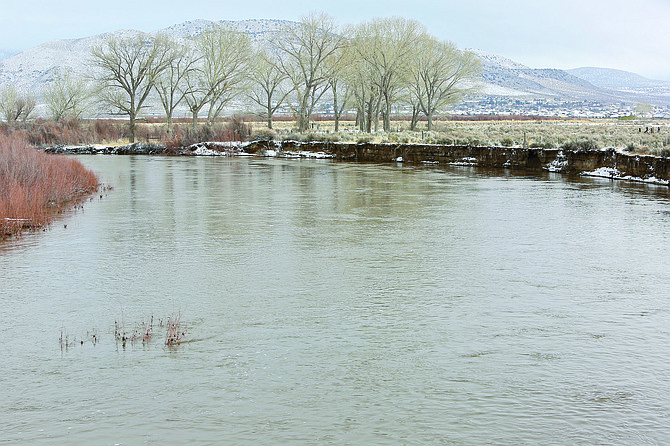
On Thursday, the Carson River at the Cradlebaugh Bridge is noticeably swollen from just a little over 24 hours previous.
Follow along with live coverage of the winter storm and potential flooding in northern Nevada. This live feed will automatically feed social media updates from Nevada Appeal staff, Carson City, Douglas County, Washoe, Lyon and state emergency management feeds. You can contribute by using Twitter or Instagram and the hashtag: #NVFlood or #NVFlood17 or #CarsonCityLive. You can also share your photos by sending them to mmoser@nevadaapppeal.com. Be safe and don't put yourself in harms way to take a photo. We update the story around this blog when possible, so it is often a good idea to refresh the page. Scroll below this blog for more information.
Tuesday 11 a.m. update: The Carson River has reached major flood status Tuesday morning in Carson City and expected to reach this status in Lyon County Tuesday night.
The river is running at about 11 feet and running very fast, according to Carson City officials. Crews don't anticipate any structures being threatened by the rise in the river, however the banks are eroding. Citizens should avoid the river banks, the rushing water flow produces very turbulent water and the characteristics of the river can change dramatically as the water level rises or falls.
The National Weather Service has issued a High Wind Warning, with strong winds possibly resulting more uprooted trees and damage to power lines. Motorists should be cautious of rapidly changing conditions and strong cross winds on Highway 50 and Highway 395.
Carson crews are continuing to monitor the river, streets and utilities to address potential hazards. Damage Assessment teams will continue their work today to motorists should be watchful of crews working as they continue to mitigate and assess storm damage.
Lyon County crews will also be out sandbagging from the Harbor/Marina Drive area in Dayton and moving east along the Carson River. Lyon County Search and Rescue is transporting filled sand bags to locations and patrolling the roadways parallel to the river to report on current flooding and new flood prone areas.
Road crews are also building a temporary fix on Dayton Toll Road for residents to get out and completing repairs to numerous roads damaged by the flooding.
Geiger Grade is also open on State Route 341 with chains and snow tires required.USA Parkway/State Route 439 is open. Canyon Way, south of LCC in Lockwood, will soon be open to CMEX mine traffic only, temporary road closures may still be in effect.
State Route 342 to Gold Hill will be closed for several days, except to local residents southbound from Virginia City. Six Mile Canyon is expected to be closed for two to three weeks.
Monday 3:01 p.m. update:
Southbound 395 closed due to flooding on both lanes. For more information about road closures and updates, click here.
Monday 2:29 p.m. update:
Lyon County is still actively engaged in flood operations. Road crews continue to focus their efforts on clearing drainage's and repairing roads that are not under water. It will be several days before all roads are fully operational.
Roads are being repaired as quickly as possible. Road crews are also preparing for snow removal that is being forecasted to begin tonight. County Manager Jeff Page and the Board of County Commissioners commend the affected public for their patience and working with our responders.
Anyone that has a life-threatening emergency is asked to call 911. If you are unable to get out of your property but have no life-threatening emergency please call the non-emergency number (775) 463-6620.
Monday 1:15 p.m. from the Associated Press:
SAN FRANCISCO — A Nevada National Guard official says high-water vehicles arrived but were not needed to evacuate residents affected by flooding in a town east of Reno.
Lt. Col. Mickey Kirschenbaum said Monday that guard members and five of the big vehicles will remain for now in Lockwood.
Kirschenbaum says it appears residents who wanted to leave a neighborhood cut off by flooding were able to make their way out.
Kirschenbaum says plans have been called off for the guard to use two more of the 2.5-ton diesel vehicles to shuttle damage assessment teams to Sparks.
He says regular emergency vehicles are being used.
Nevada Gov. Brian Sandoval plans to tour flooded areas in Reno and Sparks where residents were evacuated from homes and an industrial area flooded near the Truckee River.
No injuries have been reported.
Monday 10:30 a.m. update:
Carson City crews were hard at work throughout Sunday night into Monday clearing debris, assessing damage and cleaning up from the minor flooding Sunday.
Officials said that temperatures have dropped steadily overnight and the river continues to rise. According to the National Weather Service, the Carson River will crest below the 2005 flood stage and Carson City will see periods of unsettled weather including rain and snow into Wednesday. This may create additional hazards and road closures and drivers should still use caution on the roadways.
As of Monday morning, there are still four identified road closures in Carson: Fermi Road, Morgan Mill Road, Center Drive and Curry Street. Public Works and Parks, Recreation and Open Space crews have been working over the last 24 hours to reduce the number of flood hazards from over one hundred to six. Be watchful of city crews as they continue to mitigate and assess storm damage throughout the city.
City offices are closed Monday, however, the Sheriff's Office, Fire Department, Municipal and District Courts and Juvenile Probation are all still open.
The city has also cancelled The Meals on Wheels program for Monday. Seniors are asked to eat their provided shelf-stable meal. Welfare checks will be made on those seniors who participate in the program.
The Senior Center will be open at 9 a.m. Tuesday Jan. 10.
Sandbag locations will be restocked by Public Works Monday and residents can fill sand bags at the following locations:
- Winnie Lane/Foothill Drive
- Ormsby Road/Washington Street
- Third Street Parking Lot: 202 S. Curry Street
- Fire Station 52: 2400 East College Parkway
- City Corporate Yard: 3505 Butti Way
- Ross Gold Park: 280 East Appion Way
Continue to check carson.org/flood for up to date road closures, sandbag locations and weather updates.
Storey County updates:
County, NDOT and resources assessing all county roads and bridges. Ice forming on higher elevation roads. Road status in Storey County includes:
County wide:
1. Six Mile Canyon Road, closed long-term, not passable
2. State Route 342 Gold Hill/Silver City, closed by NDOT until clearing
3. Painted Rock bridge, open to residents only, use caution debris on bridge
Lockwood:
1. Canyon Way south of LCC, closed until further notice
2. Cercle de la Cerese, closed at bridge to Canyon Way
3. Peri Ranch Road, water over roadway, access not advisable
Highlands:
1. Lousetown Road, open, coned areas, use caution
Mark Twain:
1. Sam Clemens Road, closed until water recedes
2. Sutro Springs Road, open, use caution
Emergency Coordinating Center is in 24-hour active status. Contact NVFlood17@storeycounty.org and 775-847-INFO (4636) for updates.
Boil water order for Rainbow Bend subdivision and the Lockwood LCC Storey County Emergency Management and Canyon GID (General Improvement District) have issued a boil water order for the next 48 hours. As a result of a broken water line due to flood damage at the Cercle De La Cerese bridge, there are approximately 40 homes in the Rainbow Bend subdivision and the Lockwood LCC without water.
Storey County Emergency Management is asking all residents of Rainbow Bend subdivision and the Lockwood LCC to immediately begin conservation of water until this can be repaired and tanks filled to provide water. Expect the tanks to be filled and water available in 48 hours.
Emergency Coordinating Center is in 24-hour active status. Contact NVFlood17@storeycounty.org and 775-847-INFO (4636) for updates.
Monday at 6:30 a.m. update: The Nevada National Guard is deploying a team of five high-water vehicles this morning to assist with potential evacuations and flood support in Lockwood in response to a request from the Storey County Emergency Manager. Additionally, the Guard is deploying two high-water vehicles in support of Washoe County to move two Preliminary Damage Assessment Teams in the City of Sparks this afternoon, Lt. Col. Mickey Kirschenbaum said on Monday. The Nevada National Guard has additional personnel and resources available to assist as needed to include high water vehicles located in Stead, Reno, and Carson City as well as UH60 Blackhawk and a CH47 Chinook helicopters located at Stead.
Monday at 5:30 a.m. update: Carson City Flood Hotline number received 97 calls for assistance and as many calls to answer questions and provide reassurance. The Carson City Sheriff’s Office responded to 83 calls and the Fire Department was dispatched to 26 calls, including medical, fire alarm activations and a possible structure fire, which did not become a working incident. As of 5 a.m., the Carson River was at 7.63 feet. That was up from 3.34 feet Sunday morning at 5 a.m. The river is forecast to crest at 10.6 feet at 8 p.m. tonight. Sunday's story is here
The following Carson City agencies and facilities are closed on Monday, January 9, 2017: • Blackwell Park • Brunswick Canyon Access • Carson City Hall • Carson City Health and Human Services • Carson City Library • Carson River Park • Empire Ranch Estates Park • Fuji Park and Carson City Fairgrounds • Multipurpose Athletic Center (MAC) • Mayor’s Park • Mills Park (includes Community Center and Aquatic Facility) • Morgan Mill Road access • Parks, Recreation and Open Space Administration office • Rifle and Pistol Range • Silver Saddle Ranch • Sports Complexes (Governor’s Field, Centennial Park and Pete Livermore) In addition, all recreation programs including youth before and after school programs and youth camps are cancelled. From Lyon County, at 10:30 p.m., the final for the night: STAY HOME UNLESS YOU ARE DIRECTED TO EVACUATE BY EMERGENCY MANAGEMENT . TRAVEL IS STRONGLY DISCOURAGED! If you must travel, attempt to return home before sunset. The dangers of flooding are much more difficult to spot at night. EMERGENCY COORDINATION CENTER STATUS: OPEN FATALITY/INJURIES REPORTED: None STRUCTURES DAMAGED: 8 Confirmed – 200-400 Threatened EVACUATIONS None SHELTERS OPENED None SCHOOLS CLOSED FOR 01/09/2017 All Lyon County Schools PRELIMINARY DAMAGE REPORT STAGECOACH – 1 home reported water in their basement. Search and Rescue responded and assisted with sandbagging. Roads closed: • Kiowla and Seminole • Pueblo & Esmerelda SILVER SPRINGS • Tahoe Canal is running over with water flowing on several streets DAYTON – • Valley Circle- 8 Plex with water on first floor of homes • The following roads are closed: - Dayton Toll Road - Branstetter - Ricci Road - Rosepeak Road - Rivers Road - Lower Portion of Sandifer • The following roads are marked water over roadway - Pinecone - V & T Way - Mark Twain Way - Flowery - Champions Road SILVER CITY • Gold Canyon Creek along Dayton Toll Road-Crews are working to stabilize creek and sandbagging the banks to protect homes • Highway 342 has been closed at the Y by NDOT • Storey County will be providing mutual aid for Fire and Law Enforcement • Sand and sandbags have been deployed to the Y of 341 & 342 Highway for Silver City Residents FERNLEY • US50A/95A South Bound is closed due to water flowing over the highway • Several residents West of 50A/95A on Sage Street are threatened. • Roads closed Summer Wind Road at Ponderosa Park NIGHT OPERATIONS • Crews will continue to clear drainages • Crews will continue sand bag operations • LCSO will monitor River, drainage and bridges throughout the night • Crews will reopen roads after they are deemed safe. Previous Sunday updates: Sunday 5:35 p.m. update: Carson City residents are being asked to avoid driving on the following roadways due to water causing dangerous driving conditions: North Carson Street heading south from Winnie Lane to William Street. Lane closure due to water over roadway. South Carson Street heading south from Stewart Street to Rhodes Drive. Lane closure due to water over the roadway. Fairview Drive heading east from Roop Street to Saliman Road. Lane closure due to water over roadway. Bridge at Deer Run Road- mudslide causing travel to be difficult in the area. The following roads are closed: Fermi Road Curry Street between Lake Glenn Road and Rhodes Drive Morgan Mill Road between Empire Ranch Road and Deer Run Road. Oakridge Drive All personnel are at their full ability assisting citizens. The Emergency Operations Center encourages residents to visit www.carson.org/flood to stay up-to-date on the weather, road closures and resources that are deployed across the city. In addition, all official public information that is released from the Emergency Operations Center will be posted to the flood site. Furthermore, a Flood Hotline has been designated for flood related reporting and questions, which are not life-threatening. The number is 887-2355 and officials ask the public to use this number instead of 9-11 for non-emergency flood calls. Social media users are encouraged to share information related to the event using the official hashtag #NVFlood17. Emergency Management will be monitoring the hashtag in order to maintain situational awareness of what is occurring throughout the City. Current incident information can be found at www.carson.org/flood. Sunday 3:35 p.m. update: The following areas in Dayton are flooded due to debris and snow clogging local drainage. Branstetter Avenue at Six Mile Canyon Road; V & T Way off of Branstetter Avenue; Grosh Avenue and Sheep Camp Road; Rose Peak Road between Pine Cone Road and Flowery Avenue. Lyon County Manager Jeff Page said crews are working to relieve the blockage of water in these areas, both with hand crews and heavy equipment. Citizens should try and avoid driving in these areas. The Lyon County Emergency Coordination Center has been partially activated to direct efforts of relieve flooding situations and to coordinate activities with the State Emergency Operations Centers and surrounding counties. Sunday 2:15 p.m. update: Curry Street between Lake Glenn and Rhodes Street and Morgan Mill between Deer Run Road and Empire Ranch Road have been shut down. The Carson City Emergency Operations Center has opened and an evacuation center has been established by the Red Cross in cooperation with the Church of Jesus Christ of LDS at 411 N. Saliman Road in Carson City (adjacent to Carson High School). If you have any pets you need to bring to the shelter, the Nevada Humane Society will accept pets and take them to the shelter at 549 Airport Road. The Humane Society is open and will accept pets for those residents that need to evacuate. Carson City responders are out in the field and assisting residents as incidents arise. The EOC encourages residents to visit carson.org/flood to stay up-to-date on the weather, road closures, and resources that are deployed across the city. In addition, all official public information that is released will be posted to that site. A flood hotline has also been established for flood related reporting and questions, which are not life-threatening. The number is 775-887-2355. Officials ask the public to use this information instead of 911 for non-emergency flood calls. Social media users are encouraged to share information related to the event using the official hashtag #nvflood17. Emergency management will be monitoring the hashtag in order to maintain situational awareness of what is occurring throughout the city. Several areas in Storey County are also impacted by the flooding. Road closures in effect include: Six Mile Canyon Road, Sam Clemens and Sutro Springs in Mark Twain, and Canyon Way south of LCC in Lockwood. Crews are continuing to sandbag in Lockwood and Mark Twain and are assisting senior. The Storey County Emergency Coordinating Center is also fully active. Bridge closures may occur at Lockwood, Mustang and Painted Rock between 6PM Sunday and 4AM Monday. No bridge closures planned at this time. School district announced Monday school closures. Send non-emergency questions/concerns to hotline: NVFlood17@storeycounty.org. Call 775-847-INFO (4636) for updates. • Sunday 11:30 a.m. update: The Carson River is up to 3.8 feet, however, The National Oceanic and Atmospheric Administration has revised its forecast to put the Carson River at 10 feet by at 11 a.m. Monday. That crest prediction is down 1.5 feet from Sunday morning. The Community Center at Mills Park, Fuji Park and the Carson City Fairgrounds are closed until further notice. Nevada Division of Forestry is utilizing these locations to support emergency efforts in Carson City due to flooding. All Carson City sports complexes are closed today. • Residents are encouraged to stay indoors and off the roads for the next 48 hours as emergency crews work to clear debris and assist flooding victims. A shelter is open at 411 N. Saliman, near the high school, on the corner of Robinson and Saliman in Carson City. • The non-emergency flood hotline is 887-2355.
The Salvation Army has began serving meals at the Evacuation Center located at the Church of Jesus Christ of Latter Day Saints on Saliman Rd.
Breakfast (8:30AM), Lunch (12:30AM) and Dinner (6:00PM) will served to evacuees and volunteers daily until the shelter closes. Snacks, waters, and tea will be available 24 hours a day.The Salvation Army's team is available to evacuees to provide Spiritual and emotional support as well.
For further information about The Salvation Army's Emergency Response Team please call 775-887-9120 or visit us at carsoncity.salvationarmy.org
For more information on flood preparation visit http://www.floodsmart.gov/floodsmart/, carson.org and http://carson.org/government/departments-a-f/fire-department. Information on the state of the Carson River can also be found at http://water.weather.gov/ahps2/hydrograph.php?wfo=rev&gage=STWN2. Sunday's story: https://www.nevadaappeal.com/news/local/peak-flooding-expected-mid-monday-in-carson-city/ Lindsay Chichester, extension educator with University of Nevada Cooperative Extension, offers these tips to prepare for a potential flood. Before a flood:
- Water: At least a 3-day supply (one gallon per person per day and extra if you have pets)
- Food: At least a 3-day supply of non-perishable, easy to prepare foods
- Medications: At least a 7-day supply
- Medical items: Hearing aids and batteries, glasses, contact lenses, syringes, canes or other walking assistance tools, items for people with disabilities
- First aid kit
- Flashlight with extra batteries
- Rubber boots and rubber gloves
- Copies of personal documents (medication lists, important medical information, deed/lease to home, birth and/or marriage certificates, insurance policies, etc.)
- Cell phones and chargers
- Family and emergency contact information
- Extra cash
- Extra blankets, clothing, and shoes
- Baby supplies (bottles, formula, baby food, diapers)
- Pet supplies (collar, leash, ID, food, water, carrier, bowl, blankets, toys)
- Extra sets of vehicle and house keys
- Priceless items or valuables
- Be prepared in case there is a power outage, have electronic devices charged
- Rain gear
- Camera for photos of damage
- A NOAA weather radio which receives broadcast alerts directly from the National Weather Service
During a flood:
- Listen to the TV and/or radio for flood warnings and reports of flooding
- Check web sites (for example, http://www.water.weather.gov/ahps/)
- Take advantage of sandbags if your home/business is in a flood prone area – be prepared, as these take longer to fill than you might think. See https://www.youtube.com/watch?v=5fa8ApB_TFc for information about how to fill and place sandbags
- If you have a basement, make sure your sump pump is working, consider a backup battery operated one if necessary
- Clear debris from gutters or downspouts
- Cautiously clear small items out of waterways, anything bigger than a tumbleweed should be removed by an emergency service person
- Anchor any fuel tanks and outdoor furniture
- Move important documents and valuables to a safe place
- Be prepared to evacuate at a moment’s notice
- When a flood or flash flood warning is issued for your area, head for higher ground and stay there
- Do not try to walk in flood waters, just six inches is enough to knock you down
- Do not try to cross a flooded road, turn around and find an alternative route. Most cars can be swept away by less than two feet of water
- Keep children out of the water
- Be especially cautious at night when it is harder to recognize potential dangers
- Know your evacuation routes (several may need to be identified) and have a place to stay
- Ensure your vehicle has a full tank of gas and is ready to go if you need to leave an area quickly
- If you do not have a place to go, contact the city to determine where evacuation shelters are located
- Establish a communication plan with family – determine ahead of time where you will meet or go if you should get separated
- Use text messaging or social media to let friends and family know you are safe
If you should happen to get trapped in a building, vehicle, or outdoors during a flood, get to the highest spot you can and try to signal or call for help. After a flood:
- Only return home when officials have declared the area safe
- Shut off utilities until it can be determined that they do not pose a risk
- Use flashlights, not lanterns, torches, or matches to examine buildings, as open flames may cause a fire or explosion if gases have been leaking
- Before entering your home, look for loose power lines, damaged gas lines, foundation cracks, or other damage
- If you smell natural or propane gas or hear a hissing noise, leave immediately and call the fire department
- If parts of your home are collapsed or damaged, approach carefully
- During cleanup, wear protective clothing, rubber gloves, and rubber boots
- Be especially cautious of mold, asbestos, or lead paint contamination
- If food or water have come into contact with floodwater, discard these items
- Work with your insurance company if you have flood insurance
- Let people know you are safe
Unfortunately we cannot prevent floods, but we can prepare for them. Having a plan in place and communicating that with people closest to you will help ensure peace of mind and safety.

Comments
Use the comment form below to begin a discussion about this content.
Sign in to comment