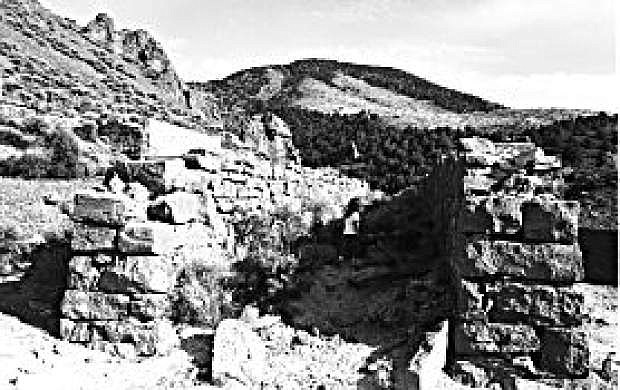
The stone remains of the Butters Mill in Six Mile Canyon.
One of the most scenic drives in the Virginia City area can be found in Six Mile Canyon, located directly east of the Comstock community.
Six Mile Canyon, along with nearby Gold Canyon, was the site of some of the state’s first mining efforts, and earliest encampments.
In 1859, Peter O’Riley and Patrick McLaughlin, two placer miners who had found promising outcroppings at the head of Six Mile Canyon, decided to enlarge a spring in order to generate more water for their placer (a type of gold-panning) operations. In the course of their digging, the two found an unusual crumbly, black rock laced with gold.
As word of the strike spread, Henry Comstock (namesake for the Comstock Lode), who had been working in the vicinity, claimed part ownership of O’Riley and McLaughlin’s claim. To avoid a dispute, the two agreed to include Comstock and his partner, Emanuel Penrod, in their operation.
O’Riley, McLaughlin and their new partners soon found that the black rock encasing the gold was difficult to remove. Since it appeared to have little value, it was discarded, but only after considerable effort.
B.A. Harrison, a ranch hand from the Truckee Meadows, however, took some of the black rock to an assayer in Placerville, who tested it and found it not only contained a value of $876 per ton in gold — but an astounding $3,000 per ton in silver.
It was this discovery, which all started in Six Mile Canyon, that sparked the “Rush to Washoe.” Within months, thousands of gold-seekers flocked to the region, which at that time was part of the Utah Territory.
Within a few short years, the massive influx of people resulted in the founding of Virginia City along with Gold Hill, Silver City, and other Comstock communities. These boomtowns provided much of the impetus for the creation of the state of Nevada in 1864.
People also spilled into Six Mile Canyon and, in the 1860s, a camp called Mount Pleasant and, later, Ophir, briefly flourished in the canyon. Several large mills, including the massive Gould & Curry, were built to handle the ore being produced by nearby mines. Additionally, homes were constructed along the road leading through the canyon.
Those mills were abandoned by the 1870s, but a large cyanide operation, called Butters Mill, was constructed in the canyon in 1902 to reprocess the huge tailing piles made during the earlier mining years.
Today, the ruins of Butters Mill highlight the trip through the canyon. Located just two miles southeast of Virginia City, the stone and concrete ruins are extensive, stretching up the hillside.
Walking through the impressive foundations and walls, it’s easy to imagine that this was once the site of the largest cyanide mill in the country. Old photos show a huge wooden structure that included a tram system to transport ore to the mill.
Butters Mill was abandoned in the late 1930s and Six Mile Canyon hasn’t experienced much action since that time (although a handful of small mining operations have occasionally been active in the canyon in recent decades).
One of the best ways to access the canyon is to head southeast of Virginia City’s cemeteries on Mill Street, which becomes Six Mile Canyon Road.
Along the way, the road passes through some large cottonwood trees and past abandoned tailing piles on the hillsides; obvious reminders of the area’s once-thriving mines.
You also pass famed Sugarloaf Mountain, the distinctive egg-shaped mound that you see when looking directly east of Virginia City. Adjacent to the road, you can see rolling hills covered with sagebrush and piñon pine trees.
At several places, there are beautiful rock cliffs covered with vivid, green lichen. In the spring, the area becomes a rich carpet of colorful wildflowers.
At about seven miles from Virginia City, the road drops out of the canyon (and the Flowery Mountain Range) and into the Carson Plains. Here, you pass through homes that have been built in the flat in recent years, before reaching U.S. 50.

Comments
Use the comment form below to begin a discussion about this content.
Sign in to comment