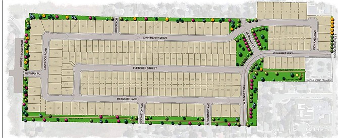
A preliminary landscape plan of Andersen Ranch Estates shows 203 home lots with smaller lots in the center and larger lots along the property's periphery, connections to outside streets and five interior roads as well as landscaping with deciduous and evergreen trees.
A new plan for Andersen Ranch, the location of the controversial Vintage project which was approved and never built, has been submitted to the Carson City Planning Department.
A tentative subdivision map for Andersen Ranch Estates, prepared and submitted by Christy Corp., will be heard at the Planning Commission’s Dec. 18 meeting.
The plan calls for 203 single-family home lots of which 134 would be a minimum 5,000 square feet and 69 would be a minimum 7,700 square feet and up to 14,930 square feet.
According to the map, the project would include roughly eight acres of open space, 12 acres of right of way, and 29 acres of lots.
Main ingress and egress would be on Mountain Street to the east and Ormsby Boulevard to the west, but connections are planned for Bolero Drive and La Mirada Street to the north and Sunset Way and Richmond and Lexington avenues to the south, all of which currently dead end outside of the ranch. Also, five interior streets would be built.
The plan would use current zoning and not the Vintage tentative planned unit development, which called for more than residences. It would also, unlike the Vintage project, be contained in the 48 acres between Mountain Street and Ormsby Boulevard and not spread into the portion of the ranch west of Ormsby.
The city Planning Division, after a major project review, replied to the developer with requirements for the project’s approval. They include a multi-use path accessible to the public along the property’s southern border; improvements to the Mountain Street trailhead; establishment of a home owner’s association to pay for and maintain all the common area and paths; and a flood conveyance design to be approved by the city’s stormwater engineer prior to the Planning Commission meeting.
A conceptual drainage study done by House Moran Consulting, Inc., is one of several appendices to the application.
“The proposed drainage improvements include channels to capture off-site and on-site runoff and convey the flow to the proposed detention ponds. The outlet structure from the detention pond will control the outflow from the site and connect to the existing storm drain on Mountain Street,” reads part of the study’s conclusion.
Other documents submitted with the tentative map includes a traffic impact study by Headway Transportation.
All the documents can be found online at https://www.carson.org/government/departments-a-f/community-development/planning-division.
Comments
Use the comment form below to begin a discussion about this content.
Sign in to comment