One of the best things about wandering the broad expanses of Nevada is finding a place that exceed expectations — like Angel Lake, located on State Route 231 in the East Humboldt mountain range south of the town of Wells.
Angel Lake is without a doubt one of the state's most picturesque small bodies of water. The lake is not named because of its heavenly allure but rather to honor of Warren M. Angel, who owned a large ranch in the nearby Clover Valley in the 1870s.
The 12-mile drive from Wells to the lake, which is one of Nevada’s official designated scenic highways, is worth the journey. Steep and winding at times, the drive is nonetheless a pleasant sojourn through rolling foothills of sagebrush and pinon pine trees.
As the road climbs higher, the surrounding terrain begins to change. Soon, groves of mountain mahogany and fields of thick grasses replace the scruffy pinon trees. At one spot, there is an impressive grove of stripped, quaking aspen that is intersected by the road.
Above and ahead is the crest of the East Humboldt Range. Like the nearby Ruby Mountains, which they resemble, the East Humboldts are among Nevada's most beautiful mountains.
There is a special appeal in looking at these rugged, ancient rocks that seem to change their appearance with the shifting light. One minute, the imposing, snow-capped peaks resemble the jagged teeth of a giant feline, and the next, they are simply uneven, stone upthrusts carved by the wind and rain.
At about 9 miles, the main road intersects with a smaller route that leads to the Angel Creek Campground. Here, the view of the surrounding hills and valleys is spectacular, with the community of Wells tiny in the distance. Farther up the road is the turnoff to Winchell Lake, a small reservoir recessed on the side of the range. Signs indicate the hiking trails that lead from the road into the mountains.
State Route 231 begins to level off as you get closer to Angel Lake. To the right is Angel Creek Campground, operated by the Humboldt National Forest, which has 26 paved campsites and a half-dozen picnic tables. Because of snow, the campground is generally open from June to early September.
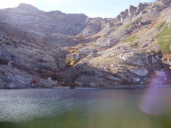
Angel Lake is not large nor is it entirely natural. Surrounded by rock walls on three sides — a manmade dam on the east side cups the water into a circular basin— it resembles a glacial lake, which it was at one time. The sheer walls consist of a crumbly, cracked rock that shows the effects of the continual heating and cooling found at such a high elevation (the lake is at the 8,378 feet level). Scarecrow limber pines hang on the mountainside, somehow surviving the harsh winters.
In the warmer months, the lake is popular with fishermen, attracted by a healthy trout population, as well as hikers who enjoy the rugged backcountry.
The lake borders the 36,000-acre East Humboldt Wilderness Area and serves as a trailhead for hiking into the region. Trails run north and south along the west flank of the mountains.
A sign indicates mileage to several points including Greys Lake, Smith Lake, Ackler Creek and Boulder Lake. Two excellent sources of information for hiking the East Humboldt range are "Nevada Wilderness Areas" by Michael C. White (Wilderness Press) and "Hiking the Great Basin" By John Hart (Sierra Club Books).
To reach Angel Lake, travel east on Interstate 80 to Wells, then State Route 231 for 12 miles to the lake via a good, paved road (it can, however, be closed during the winter months).


Comments
Use the comment form below to begin a discussion about this content.
Sign in to comment