UPDATE 11:45 a.m.:
More evacuations have been announced for South Tahoe residents that are effective immediately:
El Dorado County
Heavenly
• East of Pioneer Trail between Larch and Al Tahoe, to include the area of Heavenly Ski Resort out to the Alpine County Line and the Nevada State line on the East.
Stateline
• East of Ski run on the lake side of Pioneer Trail and also both sides of Pioneer Trail between Larch and the Nevada State line.
Evacuation Routes:
• Evacuate Eastbound on Highway 50 towards Nevada.
Evacuation Shelters:
• Truckee Veterans Hall 10214 High Street, Truckee, CA 96161
• Douglas County Community Center, 1329 Waterloo Lane, Gardnerville, NV
INITIAL POST
SOUTH LAKE TAHOE, Calif. — Additional evacuation orders were issued Monday for South Tahoe residents that are effective immediately.
El Dorado County Evacuation Order:
Fallen Leaf
Tahoma
The section from Emerald Bay north to the Placer County line in Tahoma, extending west to the border of Desolation Wilderness.
• The area from Sawmill Road at Lake Tahoe Blvd. extending north to Pope Beach. Along the water’s edge to Eagle Point. From Eagle Point west, to Desolation Wilderness, across Emerald Bay.
Pioneer
• This is the area North of Elks Club along Highway 50 and the West side of Pioneer Trail, also including the streets of Hekpa, excluding the residences west of the airport, this segment includes all residences accessed from Jicarilla, Washoan, and Glen Eagles. This also includes the Golden Bear neighborhood, and the neighborhoods of Cold Creek Trail, High Meadows, and Marshall Trail.
Gardner Mountain
Trimmer
• The area East of Pioneer Trail to the Alpine County Line stopping South of Heavenly Mountain Resort, excluding all residence off of Pioneer Trail.
• Northwest of the South Lake Tahoe Airport and west of the Highway 50 / Lake Tahoe Blvd and Highway 89 intersection to include the South Lake Tahoe High School, Tahoe Verde and the streets accessed from 5th through 15th street south of Highway 89
Evacuation Routes
• For the areas of Fallen Leaf and Tahoma go North on Highway 89 towards Truckee.
• For all other areas, evacuate Eastbound on Highway 50 towards Nevada.
Evacuation Shelters
• Truckee Veterans Hall, 10214 High Street, Truckee, CA 96161
• A Red Cross Shelter is open for those evacuating from the area at the Douglas County Community Center, 1329 Waterloo Lane, Gardnerville, NV
Notes
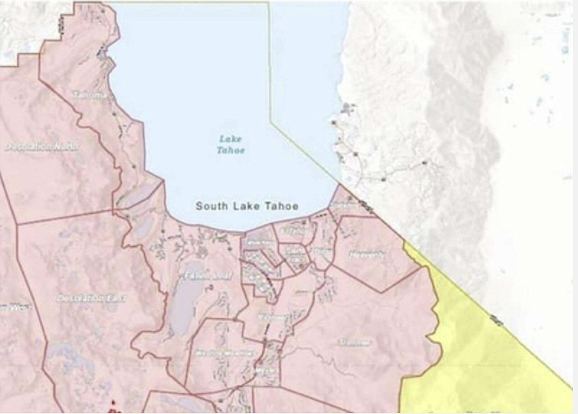
Please go to: http://www.tinyurl.com/EDSOEVAC for an online evacuation map. All previous evacuation orders and warnings remain in effect.
A mandatory evacuation order is defined as an immediate threat to life. This is a lawful order to leave now. The area is lawfully closed to public access.
An evacuation warning is defined as a potential threat to life and/or property. Those who require additional time to evacuate and those with pets and livestock should leave now.

Comments
Use the comment form below to begin a discussion about this content.
Sign in to comment