Carson City supervisors will consider election map changes
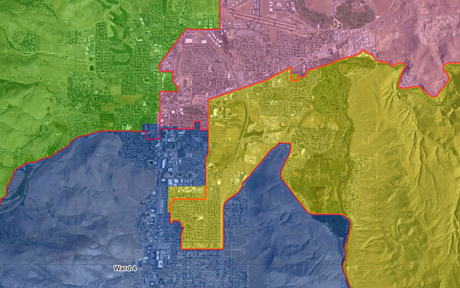
Changes to the election ward map are largely concentrated along the downtown corridor, adding residents to Wards 3 and 4. The Clerk-Recorder’s office redraws the map every 10 years to reflect population shifts captured in the U.S. Census.
The Carson City Board of Supervisors will meet Thursday to consider adopting a new election ward boundary map. They will also discuss changes to the Carson City Municipal Code ward boundary laws. Carson City’s “wards” determine which part of the city each supervisor represents. Residents vote at large, meaning they may cast a vote for any candidate running for the board. But supervisors run to represent their ward, so no supervisors on the board live within the same ward, and each supervisor represents a different portion of the city. The proposed wards are balanced so that each has approximately 14,700 residents. The new ward boundary changes are minimal. Some folks along Fairview Drive in between Saliman Road and Carson Street in Ward 4 will move into Ward 3. Several blocks near the intersection of Musser Street and South Division Street spanning Wards 1 and 2 will move into Ward 4. And a small segment of the neighborhood between Sweetwater Drive and Gordon Street will join Ward 3, moving away from Ward 2. Currently, Stacey Giomi represents Ward 1; Maurice White represents Ward 2; Stan Jones represents Ward 3; and Lisa Schuette represents Ward 4. The Carson City Charter requires that new wards be adopted by ordinance (law), but currently the municipal code says that new ward boundaries are adopted by resolution. So, with the new election map, the supervisors will also consider changes to the municipal code to make it consistent with the city charter. They will adopt the new ward boundaries by ordinance, which requires two meetings to confirm. Since the map must be finished before 2022, the supervisors have a separate agenda item to schedule a special meeting before the end of December, to adopt the election map into law. Among other agenda items, the supervisors will: • Review the annual comprehensive financial report for the fiscal year, which ended June 30. • Adopt master plan and zoning ordinance changes to re-zone homes near Lepire Drive and a parcel off Highway 50 near Empire Ranch. • Interview candidates for the Regional Transportation Commission and appoint two new members. • Authorize Carson City Health and Human Services to apply for a $2 million grant to support family planning and preventive health services staff. • Transfer land along Butti Way to Oikos Development for an affordable housing project. Residents are welcome join the meeting in-person in the Robert “Bob” Crowell Board Room at the Community Center on 851 E. William St. The meeting will begin at 8:30 a.m. Public comment will be held and the beginning and the end of the meeting. The meeting will also be livestreamed via www.carson.org/granicus. Follow the “In Progress” link to access the live feed. Alternatively, viewers can tune to cable channel 191 to watch the meeting. Residents who cannot attend the meeting but would like to make public comment may email publiccomment@carson.org or call in during the meeting, 408-418-9388 with meeting code 2499 723 4248.

Comments
Use the comment form below to begin a discussion about this content.
Sign in to comment