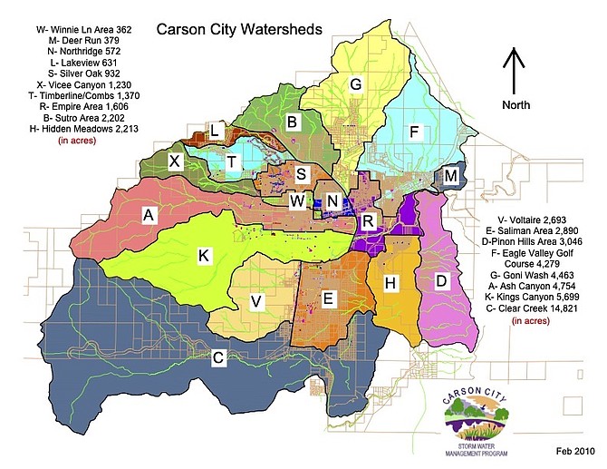
A map from Carson City Stormwater Management Program showing watersheds throughout the capital city.
Local watersheds fit together like pieces in a puzzle, and the more they can be understood, the more they can be predicted and, if necessary, mitigated to prevent catastrophic events.
“When a community invests in mitigation before damage occurs, every dollar they spend on mitigation saves $7 in flood disaster costs,” said Debbie Neddenriep, water resource specialist II for the Carson Water Subconservancy District.
Neddenriep and Carson City Chief Stormwater Engineer Robb Fellows – also the city’s floodplain manager – talked to the Appeal about floodplain mapping and regional planning. The two work together on watershed projects in Carson City but under the guidance of the Carson River Watershed Regional Floodplain Management Plan. That plan, adopted in 2008 and revised in 2018, includes Alpine County in California and Douglas, Lyon, Storey, and Churchill counties in Nevada, as well as Carson City.
“Each county has the potential to impact downstream communities, making flooding a watershed‐wide challenge,” Fellows said.
Carson City, for instance, has 19 smaller watersheds that create drainage areas.
“The main goal of the regional plan is to develop strategies for floodplain management that can be applied watershed-wide as well as locally,” said Fellows. “Included in the plan are suggested actions that encourage communities within the Carson River watershed to recognize the value and critical functions provided by floodplain lands for public safety and reduction of costly flood damages.”
CWSD is what’s called a “cooperating technical partner,” meaning CWSD works with FEMA and receives FEMA dollars to reduce flood hazards in the Carson River watershed. This FEMA funding spills into Carson City. Over the last decade, for example, $1.48 million has been used in the capital area to update flood insurance rate maps (FIRMs) and create drainage plans for alluvial fans. New FIRMs include the Eagle Valley Golf Course drainages (2016), Goni Wash (2017), and Voltaire Canyon and tributaries (2019). Clear Creek FIRMs are currently being updated and include portions of Carson, Douglas County and Washoe Tribal lands.
“More accurate FIRMs have resulted in accurate flood information for the city and its residents who pay flood insurance,” said Neddenriep.
Neddenriep said drainage studies consider not only the channels of alluvial fans, but also soil type, drainage patterns, culvert sizes, and roadside ditches “to then provide alternatives to the city for the best ways to reduce flooding in the most cost-effective manner.”
A drainage study for North Carson was completed in 2019, and the West Carson City Drainage Study was completed in 2021. Currently, area drainage plans are being completed for east and southeast portions of the city. Like tributaries of the Carson River, all these maps and plans flow together into unified management.
“These drainage plans inform the city’s capital improvement inventories and schedules and identify infrastructure projects to reduce flooding throughout the city,” said Neddenriep.
Carson City has taken initiative not only in mitigation measures, but in watershed protection. In 2021, the Board of Supervisors adopted a new drainage manual of “low impact development” standards that outlines LID practices for potential developers.
“LID is a land development practice, modeled after nature, that improves and enhances water quality by reducing runoff and nonpoint source pollution through design techniques to mimic the predevelopment hydrology of a site,” Fellows explained. “LID works in conjunction with mitigating increased runoff from development. It’s been over a year since LID became a requirement. So far, engineers have included LID in their designs as required.”
Asked if LID has affected proposed projects like Andersen Ranch West along Ormsby Boulevard, Fellows said, “Including LID hasn’t been an issue when incorporated into the design for a new project.”
That planned subdivision on the historic Andersen Ranch was denied by planning commissioners on Sept. 28 due to several concerns, including flooding. Commissioners’ recommendation will go to the Board of Supervisors.
According to the city’s Stormwater Management Program, since Carson City was founded in 1851, there have been 29 major flood events, or one about every five to seven years. Recent major events include a flood in 2005 that caused more than $2 million in damage, and the mass flooding of 1997 that caused $5.3 million in damage.
Neddenriep said the regional plan has helped prepare for future events as pieces of the puzzle fall into place.
“I think Carson City takes credit for 71 percent of its floodplains lands as open space,” she said. “This is an amazing amount of open space. Residents enjoy these open spaces year-round, but when it floods, the water storage they provide is the number one way to reduce flood disaster costs.”
Neddenriep said while Carson City is doing excellent work, there is more to be done regionally.
“In 2015, the University of Nevada, Reno, did a floodplain inventory of the Carson River watershed. Thirty-one percent is protected, but 69 percent is subject to change,” she said.
Neddenriep cautioned the percentages might have changed as Carson City has acquired more land since the study.
Fellows said the regional plan acts as a starting point.
“This plan is intended to be a starting point and a living document that guides the implementation of the suggested actions,” he said.
For information, visit http://carsonsw.org/regionalfloodplainmanagement/.

Comments
Use the comment form below to begin a discussion about this content.
Sign in to comment