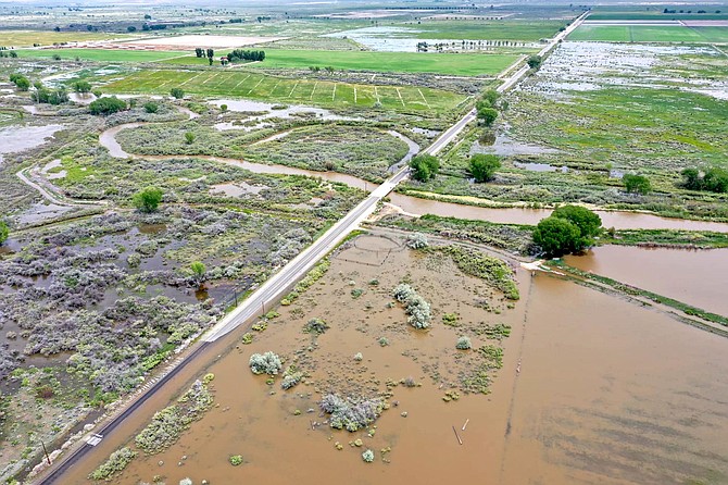
A drone aerial image of flooding occurring on May 28 on Miller Lane.
Lyon County has been taking emergency measures to reinforce the Walker River’s banks and protect private properties in Mason Valley following a record-breaking water season and slow-yielding spring thaw, according to officials.
While county officials acknowledge the immediate action residents and emergency management agencies took to reduce the threat, they say more is needed to keep roads and infrastructure intact from future weather events. Miller Lane, one of the Yerington’s major roadways, remains closed, and the stretch between Bridge Street and Goldfield Avenue also has points of concern.
“Our primary focus has been protecting those folks (in Yerington), life safety issues and also securing the sewer system from inflowing in inundation for several weeks,” Lyon County emergency and communications manager Taylor Allison said in June. “We haven’t seen major impacts to the city’s sewer system, which has been great.”
The project is being completed in partnership with the U.S. Army Corps of Engineers and local agricultural partner Peri and Sons, which has provided technical and physical assistance.
“It was a great operation, and if you stand on a levee in a section between Bridge Street and Goldfield Avenue, you’ll see the water was standing higher than town, which was amazing,” Allison said. “I’m sure they’ve been impacted by the Miller Lane closure, there’s increased traffic. It’s nerve-racking to hear your business could flood. What’s going on, we’re not out of the woods yet. I hope at the end of this, everyone is appreciative of what’s been done.”
When flooding began
Initial high risk of flooding first was identified approximately May 19 in Yerington, when Lyon County received its first reports that agricultural business Mason Valley Equipment was in a low-lying area and resident and farm manager Jim Snyder’s property would need assistance, Allison said.
“We started having discussions with (Peri and Sons) about building just that section, and they started the work and we had an emergency meeting with Lyon County,” she said.
May 20, county commissioners directed County Manager Andrew Haskin to take emergency measures to reinforce the Walker River banks in low-lying areas — such as the Mason Bridge — and the city’s critical infrastructure. A section of the river between Bridge Street and Goldfield Avenue began flooding, with the National Weather Service’s California Nevada River Forecast Center in Sacramento reporting a downgrade in its forecast to flows of 3,900 cubic feet per second (CFS). This was still more than 1,500 CFS above what the county had expected, and Haskin told the board it would be prudent to take emergency action to shore up banks along private property.
“We feel there’s a strong possibility if the river were to break the banks there, it would flood Yerington pretty significantly,” Haskin said during the emergency meeting.
Allison said work began on building levees and berms immediately with the May 20 approval.
“Had work not started that week (of May 22), we would have started seeing flows,” she said. “When we started those conversations, our worst-case scenarios were above 3,000 CFS at the Snyder gauge, and now we’re comfortable. We don’t want to get above 4,000 CFS. Since then, we’ve had the U.S. Army Corps of Engineers out a few times, and they’ve provided recommendations on all the low-lying areas. For the most part, flooding has been isolated to those directly on the river on the Mason Bridge and Mason Road, and we haven’t seen other significant impacts to critical infrastructure.”
Emergency assistance: USACE report
Once Yerington received major flooding the week of May 22, a technical report by the USACE’s Sacramento District office was prepared. The report refers to coordinating with the Nevada Division of Emergency Management for assistance. USACE team members, including Benjamin Kochman and Mickey Huynh who authored the report and it was reviewed by David Kingston, made three visits on May 25, June 6 and June 21 to assess flooding impacts and city needs.
The report provides four recommendations to help the county in its future flood mitigation efforts as a response to structures that had been built to the county’s 1997 flood that also inundated Yerington and closed its water treatment plant.
“Our team provided recommendations of actions that local officials could implement to help address near-term flood concerns; however, additional investigation and information would be required for comprehensive long-term recommendations,” said Tyler Stalker, deputy chief of public affairs of USACE in Sacramento.
The report summarizes pre-flood conditions and further measures the county should take from this year’s season. The USACE analyzed the confluence of water and states Yerington’s water treatment plant is “particularly vulnerable,” noting “if floodwaters reach any manhole in the city, this could prompt an emergency evacuation.”
The four recommendations address critical infrastructure needs according to “reach” identification.
Reach A’s recommendation to monitor multiple sections of levee and berm cover Snyder Lane to Mason Road and were described as “areas of the least concern” since “setback levees provide room for the river to swell and for the energy of the rushing waters to dissipate.”
But Kochman and Huynh said monitoring should be continuing and noted the community should watch the area south of the Mason bridge since floodwaters had covered riverbanks behind a culvert. They suggested HESCO barriers be deployed on the road during water backups.
Reach B, going from Mason Road to Bridge Street, showed three areas in need of riprap on the levee or berm structure’s waterside, the report states. Riprap, made of boulders 18 inches or larger, could be placed waterside along the levee or berm starting 75 feet before the bend of the area to 75 feet after.
Also for Reach B, the report identifies an operation that had been in place to pump water from Peri’s farm into the river and said this was causing part of the berm in the area to fail. Kochman and Huynh recommended repair and monitoring of this location, as well as placement of HESCO barrier placement near Sprague Drive south of Bridge Street.
The area lining from Bridge Street to Goldfield Avenue identified as Reach C is described as “an area of concern” in the report since the river has changed course with water running against a previously established setback berm, Kochman and Hunyh write. They state material was placed to reinforce the berm and recommend more should be added to prevent breaches or overtopping. They also refer to an empty trailer park located on the west bank of the river south of Goldfield and say flooding of this facility is not a concern at this time.
Reach D, extending from Goldfield Avenue to the weir north of town, experienced a breach on the day of inspection, the report states, and should be filled with material in the berm to keep breaches from occurring. The weir also should be monitored for other structural issues or failure, the report notes, so high waters do not “scour” issues.
Local partners
Between May 25 and May 26, peak flows were occurring between 3,200 and 3,600 cfs, along Mason at Snyder Lane, according to the National Oceanic and Atmospheric Administration.
Allison said as of June 26, flooding still occurs north of Yerington’s Miller Lane with impacts to the Mason Wildlife Management Area, including the Nevada Department of Wildlife and fish hatchery areas. The county continues working with the Fort Churchill power plant and Nevada Energy to make sure it’s running.
“There is flooding in and around the area of the Fort Churchill Generating Station,” said Meghin Delaney, media relations manager of Nevada Energy. “NV Energy is closely monitoring the situation and working in conjunction with Lyon County and the Nevada Division of Emergency Management with plans in place to mitigate any issues that may arise.”
Credit where credit is due
Four residents had been displaced due to flood inundation, and Allison confirmed Lyon County Human Services has been providing them with assistance. Additionally, the Building Department has been working to get them back into their homes, she said.
Overall, officials have offered expressions of gratitude for the contributions that went into keeping Lyon’s communities running since March.
“Lyon County is grateful for the emergency flood work that was done by Peri and Sons, the Walker River Irrigation District, Lyon County staff and the many others that provided help,” Haskin said in a statement. “Without their efforts, the flooding impacts to the City of Yerington and the surrounding area would have been significantly worse.”
Lyon County Commission Chair Dave Hockaday said staff members have worked hard more than 12 hours a day to ensure operations kept going between high flood time.
“We’re not out of the woods yet,” he said. “Yet, we still have hot weather coming and snowpack still melting. It’s nice to have a little bit of a break and the river flow’s down a bit. I’m pretty pleased with how the county staff’s reacted to get the east side of the river built up over in Mason.”
Hockaday also thanked WRID general manager Bert Bryan, whose job, he said, was to help deliver water to local farmers and ranchers “and not be our flood control manager.”
“He’s stepped up to help the community,” he said.
The county also credited Peri and Sons and the Walker River Irrigation District’s efforts in building levees and berms that have protected approximately seven miles along the east bank of the Walker River during some of this spring’s most productive rains and confluence of water where it forks from the weir north of the City of Yerington and the Yerington Municipal Airport.
2023 Community Flood Preparedness Guide
Lyon County Coping with Disaster Flyer 2023
2023 Nevada Dept of Agriculture - Disaster Assistance Flyer
WRID How to Sandbag Your Property English and Spanish

Comments
Use the comment form below to begin a discussion about this content.
Sign in to comment