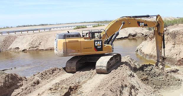
An excavator removes a piece of dirt to allow water to flow in the "Big Dig" channel.
For years to come, this year’s flood mitigation efforts among dozens of government agencies will be long remembered.
Incident Commander Bill Lawry, Churchill County’s retired sheriff and currently an assistant fire chief, presented an overview of the past five months at Wednesday’s monthly Churchill Economic Development Authority business breakfast.
Lawry said he has been involved with government 47 years, and for the first time, he saw how it could work efficiently with all agencies focusing on helping Churchill County.
“We got 50 agencies together and made it work,” he said. “When government works, it works really well.”
Lawry took his audience through the most important developments once the region’s water managers, hydrologists and meteorologists realized they had a major natural disaster waiting at their door. Although the worst may be over, Lawry said flood mitigation continues.
Lahontan Reservoir, which has a capacity of 294,000 acre-feet, can expand its storage to 312,000 acre-feet with flashboards that can hold back more water. (An acre-foot of water equals 386,000 gallons.) Lawry said the Truckee Carson Irrigation District began installing flashboards and should be finished with the project by the end of the week.
He said water could be lapping at the bottom of the rim by today or Saturday, and within the next two weeks, water could be flowing over the boards.
Lawry said the released water from the reservoir flows down the Carson River to Diversion Dam, located about 12 miles west of Fallon. He said the county receives its water from three sources: The V-line canal, the T-line canal and the Carson River, which meanders through the valley and travels north of Fallon to the Carson Sink.
“The system was designed if there was overflow, it would go down the river” Lawry explained.
The water-delivery system, which was constructed because of the Newlands Reclamation Project more than 100 years ago, consists of 700 miles of canals crisscross ingthe rich agricultural Lahontan Valley. Lawry emphasized the system serves as an irrigation project although during the early 1900s before the project was constructed, Fallon faced severe flooding. Flooding pushed less than a foot and a half of water into town in 1903, as indicated by old-time photos showing water surrounding the courthouse.
As for 2017, though, Lawry said the reservoir has released 456,452 acre-feet of water to allow for water storage management, but in June, the reservoir has taken in another 80,245 acre-feet. Projections earlier in the year suggested 588,000 acre-feet of water would need to be released.
Lawry said hydrologists indicate another 120,000 arce-feet of snow water remains in the higher elevations of the Sierra that will eventually trickle down to the Carson River. Since January, Lawry said about 900,000 acre-feet of water has flowed down to the Carson River to the reservoir, and by the end of July, he said that amount could be near or top 1 million acre-feet. Most of the snowpack comes from the Ebbetts Pass area south of Lake Tahoe.
Snowpack was estimated at 250-300 percent of normal, which Lawry said equaled the capacity of almost three Lahontan Reservoirs To stay ahead of any potential danger, Churchill County and TCID received permission from the state in February to use seven excavators to clear out debris from the Carson River,
“That is the most important thing we did,” said Lawry adding after the cleaning, TCID began precautionary water releases.
To handle the flow of excess water, an emergency weir and spillway were constructed off the V-line canal in March, a project that took three weeks. Lawry said the weir allowed thousands of acre-feet of water to flow into the desert toward Sheckler Reservoir and then to a Navy training range before winding its way to U.S. Highway 95.
“Basically, it’s a safety valve,” Lawry explained.
Before water flowed into the desert from the V-line, local agencies approached the state for help to install drainage culverts under U.S. 95 south of Fallon. Lawry said four culverts with each one having triple drains were strategically placed to move the water from the desert to Carson Lake. The Nevada Department of Transportation and its contractors took a week to install the culverts on U.S. 95 and several weeks later, NDOT and a contractor installed culverts on U.S. Highway 50 between Wildes Road and Grimes Point to move water in a northeasterly manner.
Lawry said the “Big Dig” commenced with volunteers and government crews digging a diagonal drain of 60-feet wide and about 15-feet deep from north of Carson Lake to the Stillwater National Wildlife Refuge in less than one month. The final two weeks of the project saw crews working 24 hours a day.
Lawry said the channel’s depth is 24-feet in some places but averages 13-feet deep along its 17-mile course.
Lawry gave credit to the Farmer Brigade, volunteers from the area’s ranches and farms who donated their time and equipment to scrape off the top layer of dirt so excavators could dig out the channel.
With infrastructure in place, Lawry said the rest of the summer now begins with a waiting game to see how the river, canals and “Big Dig” handle the water.
Even with water flowing over the reservoir’s flash boards, Lawry said water managers feel the area will be able to handle the flows. As another precautionary decision, Lawry said water is being ramped up in the Carson River to handle excess water.
As for any worst-case scenarios, Lawry said the weir, which closed last week, could reopen to send additional water into the desert, an idea Lawry doesn’t want to see.
“Sending water out into the desert is a waste,” he said. “Let’s keep as much water as we can (in the reservoirs).”
An attendee at the breakfast asked Lawry what would have happened if nothing had been done to mitigate potential flooding.
“We would probably be under a foot or more of water for 131 days,” he quipped.
The entire project to intall the weir, culverts and complete the channel has a price tag of about $4 million. At this time, Lawry said the city, county and TCID are paying for the repairs, but the agencies have submitted paperwork to receive about 75 percent reimbursement from the Federal Emergency Management Agency (FEMA) and about 12.5 percent from the State of Nevada.
Lawry said the past five months have been a challenge, but the overall efforts performed by all agencies working together have been worth it to protect the community.
Comments
Use the comment form below to begin a discussion about this content.
Sign in to comment