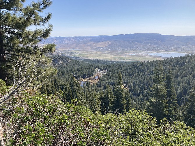
This column is part two for Davis Creek. To read part 1, click here: If you want to get deep in nature, and high above Washoe Valley, the trails at Davis Creek Regional Park will do just that for you. The Ophir Creek Trail at Davis Creek Regional Park is difficult, with some heavy-duty elevation gains that go straight uphill without switchbacks. But the reward is incredible. Shorter Option You don’t have to hike to the end of this trail to enjoy it all. Most people take the short option and make their way to a creek crossing. It’s about 954 feet of elevation gain, and roundtrip total is about 3.1 miles, depending on where you park. This creek is interesting because it’s filled with large boulders that fell from a rockslide in 1983 (from Slide Mountain, which can be seen to the north west in Carson City). The rocks filled in the creek. There’s a trail carved through, so you don’t have to climb on top of the large boulders. Some makeshift bridges will help you get across if the water is rushing. There are some comfortable spots to stop and rest or get some good pictures of Slide Mountain. TO ROCK LAKE Beyond the creek crossing, the trail starts to go up again, and quickly. The trail surface in this part become a bit rockier too, as parts of it are from an old logging road. In one section that seems to go straight up, there’s a detour to the left that overlooks the valley. That’s a good place to take a rest and get an awesome view. Going up just a little farther, there’s relief when you see two wooden signs. PRICE LKS 1.5, to the left, and ROCK LAKE to the right. The trail to Rock Lake is downhill for about 0.5 miles, then you get to your destination. There’s about 1,932 feet total of elevation gain on this trail. Rock Lake is filled with boulders from the 1983 rockslide. It’s unlike many lakes you’ll see. All around it are large boulders, making the shores not too inviting. The water level makes a huge difference what you can see. This year the lake is very low. After checking out the lake it’s best to turn around and take the same trail back. TO PRICE LAKE It takes some great ambition to get all the way to Upper Price Lake, but it’s worth it. Once you turn left at the intersection with Rock Lake, the elevation keeps going higher. After that uphill section, it levels out, and the forest opens wider. There’s a section with huge, smooth chunks of granite sticking out. It’s kind of a neat area and very flat. The trail through this part isn’t as obvious, but if you follow the open area around, it’s not too hard to find your way to a more defined trail, which is County Road 315. This last section of the trail, approximately 1 mile, is flat and follows a dirt road. You’ll get the highest views of Washoe Valley from here. You’ll have birds-eye view of Rock Lake. Right before getting to the lake there’s a water crossing. In May, this water was about a foot deep, and the best option was to take off socks and boots and walk across. The rocks weren’t too bad on the feet, but the water sure was cold. Price Lake is calm and peaceful. Slide Mountain provides a rocky backdrop on one side, and trees surround the lake. There’s a man-made dam that helps control the flow of water and you can hear it rushing through there early in the year. When you get close to the water you can see fish. It’s a very peaceful spot and it’s a great feeling knowing how hard you worked to get there. It’s worth taking a moment to relax before heading back the 4.8 miles to get home. Depending on the time of year, the snow can linger in this spot longer than elsewhere. So, if you go while it might be snowy, bring the proper gear or prepare to turn around when you get too high. To Upper Price Lake is about 9.6 miles roundtrip with 2,680 feet of elevation gain. Where you park will change the mileage slightly. Always remember to respect nature and other hikers. Leave no trace and take everything you brought in back with you. Kyler Klix is a designer for Nevada News Group. He also writes about the outdoors and entertainment. Email him at kklix@nevadanewsgroup.com.

Comments
Use the comment form below to begin a discussion about this content.
Sign in to comment