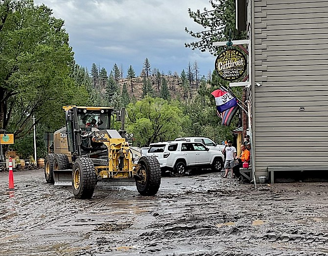
Downtown Markleeville digs out after a flood brought 1.82 inches to the town, closing Highway 89. Photo by Stephen Hibbs
Highway 89 remains closed today between Markleeville and Woodfords as Alpine County residents prepare for another stormy afternoon.
As of 11:45 a.m. Thursday, the California Department of Transportation reported that Highway 89 between Turtle Rock Park Road and Montgomery Street in Markleeville remains closed after mud and debris washed out part of the roadway on Wednesday.
CalTrans Officials say there is not estimated time to reopen the highway. The only way in and out of Markleeville is east over Monitor or Ebbetts Pass while crews clear the mud.
More showers and thunderstorms are expected to develop today and Friday, according to the National Weather Service in Reno.
A flash flood watch remains in effect for most of the Sierra Front through 10 p.m. tonight.
“The additional heavy rain on top of what has already fallen this week will continue the threat of flash flooding, particularly near burn scars, small creeks, and steep terrain,” forecasters said.
National Weather Service radar indicates a small storm cell is developing along Highway 395 south of Topaz Lake in Mono County.
Aug. 3 story
As much as 2.49 inches of rain brought mud and debris into the historic town of Markleeville on Wednesday evening.
Flooding closed Highway 89 between the Alpine County seat and Woodfords, which left Monitor Pass as the only route into town.
The California Highway Patrol reports that Highway 89 will remain closed until Thursday morning.
"That mud appears to have been delivered by Millberry Creek, which runs alongside the highway from the north," said Stephen Hibbs who was in town during the flooding. Storm clouds obscured the high Sierra and into Carson Valley during the storm that prompted a flash flood watch for much of the Sierra Eastern Front and Western Nevada.
Fredericksburg resident Jeff Garvin reported receiving .78 inches of rain from the storm. The flash flood watch will continued through Thursday evening as wet monsoons bring thunderstorms to the region.
Alpine County issued an emergency alert for flash flooding near Markleeville and along highways 88 and 89 near Monitor Pass at 4:25 p.m. after 2.27 inches of rain fell in Markleeville over the course of an hour.
The National Weather Service in Reno reported thunderstorms were producing heavy rain across parts of Alpine County.
“Grover Hot Springs State Park Employee and California
Highway Patrol confirmed several debris flows crossing Grover Hot Springs Road with large boulders on the road,” according to the flash flood warning. “Excessive rainfall over the burn scar is resulting in debris flows moving through the Tamarack burn scar. The debris flow can consist of rock, mud, vegetation and other loose materials.”
Locations that may experience flash flooding include Topaz Lake, Alpine Village, Woodfords, Grover Hot Springs, Mesa Vista, Alpine County Airport, Indian Creek Reservoir, Junction highway 89 and 4, Indian Creek Campground, Turtle Rock Campground,
Markleeville and Holbrook Junction, according to the Weather service.
Douglas County currently has self-fill East Fork Fire Sand Depository stations at the following locations:
• Johnson Lane Fire Station, 1450 Stephanie Way, Minden
• Genoa Fire Station, 2298 Main St., Genoa
• Fish Springs Fire Station, 2249 Fish Springs Road, Fish Springs
• Ruhenstroth Fire Station, 2008 Pinto Circle, Ruhenstroth
• Sheridan Fire Station, 980 Centerville Lane, Sheridan
• On the right-hand side of Leviathan Mine Road near the inside fenced area water tower
• Holbrook Highlands, off of Highland Way near the green water tank, off Highway 395
Visit www.weather.gov/bou/floodafterfire for more information.
Previous Story
Douglas County is bracing for the possibility of flooding in the burn scars after the National Weather Service in Reno issued a flash flood watch for noon today through Thursday evening.
“Heavy rainfall could trigger flash flooding of low-ling areas and debris flows in and near recent burn scars,” forecasters said. “Residents and those recreating in and immediately next to recent burn scars should prepare for potential flooding impacts.”
Forecasters advised residents to be ready to move to higher ground should a flash flood warning be issued.
The watch covers a broad region of the Sierra eastern slope east to the Mineral-Nye county line.

Comments
Use the comment form below to begin a discussion about this content.
Sign in to comment