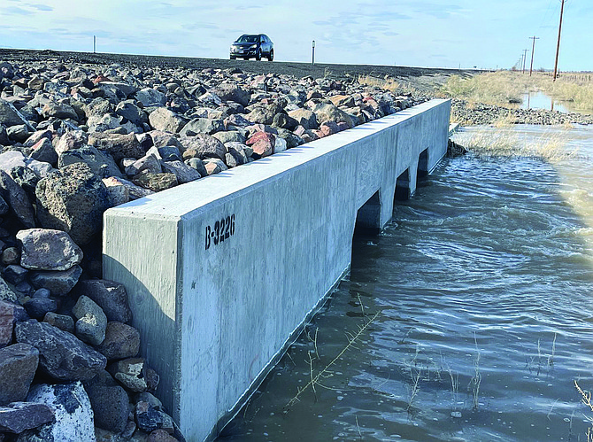
Water diverted from the V-line canal flows under one of the culverts under U.S. Highway 95
Nevada News Group
With the approval of funding for a second weir on the V-line canal, heavy equipment is being moved into place to more than double the outflow of water into the desert.
According to a media release from Churchill County, Casey Road is closed at the cattle crossing before the 26-foot drop where a hydro-electric generation facility is located.
As presented at a special meeting of the Churchill County Commission, the weir will be located downstream from the first emergency weir that was constructed in March 2017 to rechannel water from the V-line canal south to the desert.
Churchill County is also requesting residents in the area to avoid the west ends of Sheckler and Casey roads as large equipment and supplies are being moved into place to build the second weir.
Both the city and county have declared emergency declarations, and Gov. Joe Lombardo has declared emergencies for most of Nevada’s counties.
Commission Chairman Bus Scharmann said the second weir will be larger and located 50 feet downstream from the first weir and to accommodate an increased outflow from the current 750 cubic-feet-per-second off the V-line to 3,500 cfs. The expected date for completion is mid-May.
At a March town hall meeting, Scharmann said doubling the flow of water from the canal to the desert will help mitigate flooding along the Carson River and canals. Two other concerns also arose at the town hall meeting. Every effort will be made to keep water from flooding residences downriver from the dam, and residents who are concerned with flooding are advised to walk around their property, construct berms if possible and place sandbags at vulnerable points.
In addition to Churchill County and TCID, the city of Fallon, Bureau of Reclamation and other agencies are working together to mitigate any flooding.
Currently, water from the V-line is flowing south from the weir and eventually veers southeast to cross under U.S. Highway 50 between the junction with Pasture Road (Nevada State Road 720) to about one-mile north of the turnoff for Top Gun Raceway.
Eventually, the water flows to Carson Lake and from there it is eventually channeled through a 17-mile long channel called the Big Dig to the Stillwater Wildlife Refuge.
The county also said the following mitigation efforts have been implemented.
The Churchill County Road Department and TCID have cleaned out the Big Dig of debris and silt to allow water to flow more efficiently through the channel.
Road Department is building up the berm along Pasture Road to a height of six feet to allow for increased water capacity in the Carson Lake by the end of the month.
Local youth, working with county crews, will fill, deliver and set-up sandbags for seniors and those with mobility issues who live along the Carson River in Churchill County on April 22 from 9 a.m. to 1 p.m. Call the High-Water Call Center weekdays from 8 a.m. to 5 p.m. at 775-867-5923 by April 19 to make arrangements for this free service.
Sandbags may also be picked up from 485 Miners Road at the following times: Monday through Friday: 10 a.m. to noon and again from 12:30 p.m. to 2:30 p.m.; Saturdays and Sundays: 9 a.m. to 2 p.m. For seniors and residents with mobility issues who live on the Carson River, sandbag delivery is available by calling the call center at 775-867-5923.
According to the National Resources Conservation Service’s Nevada office, the Carson Basin has more than enough water to fill Lahontan Reservoir. Weather models from the various agencies monitoring the snowpack and water flows estimate the water content contains upward to 1.3 million acre-feet of water in the Sierra Nevada.
Each acre-foot of water would cover a football field with one-foot deep of water. TCID has been able to draw down Lahontan Reservoir under to 100,000 acre feet.
The Lahontan Reservoir is not the only body of water facing storage problems this spring. The NRCS said water managers in the Walker Basin are drawing down the Topaz and Bridgeport reservoirs because of the extreme snow amounts in that basin. In the Humboldt Basin, water is flowing the length of the Humboldt River to Rye Patch Reservoir.
Furthermore, the NRCS said the streamflow forecasts for the April-July period show every forecast is above 200% of median, while many are 300-600% of median. The NCRS said several streamflow forecasts are in excess of 1,000% of median.
The water call center telephone number is 775-867-5923, and it will be staffed weekdays from 8 a.m. to 5 p.m.
Important websites:
• City of Fallon: www.fallonnevada.gov
• Churchill County: www.churchillcountynv.gov
• Truckee River Operating Agreement (water reports): www.troa.net
• Lahontan Valley News: nevadaappeal.com

Comments
Use the comment form below to begin a discussion about this content.
Sign in to comment