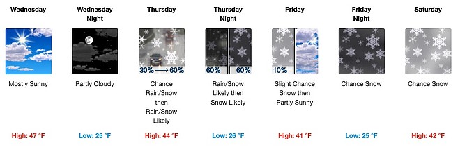
Graphic by NWS showing snow arriving to the Carson City area Thursday.
The transition to December toward the end of the week could bring light snow to valley floors in the Carson City area, according to the National Weather Service.
“Northwest flow aloft will allow for a couple of shortwaves to move through northern CA-NV, one late Thursday into early Friday morning and a second right on its heels Friday night,” the NWS said Tuesday. “Temperatures will remain cold with snow levels down to most valley floors.”
The NWS said the Sierra could see up to six inches of snow at mountain crests, while valleys in Western Nevada could accumulate less than one inch. The chance of precipitation in Carson City Thursday night is around 60 percent, according to estimates.
“Impact potential is there for travelers, especially outside of daylight hours,” warned the NWS.
Slick roadways are a possibility before high pressure and dry weather return early next week, the NWS said.
“Light rain/snow showers may be ongoing across northeast CA/northern NV on Sunday before the flow off the Pacific lifts a bit north in response to a shortwave ridge Mon.-Tue.,” said the NWS. “Beyond Tuesday, confidence decreases as some scenarios show a flattening ridge and additional systems brushing our area. So we could see additional rounds of precipitation midweek. Next week does look milder than this week, regardless.”
Temperatures are expected to stay between the 20s and 40s (Fahrenheit) through Sunday.
For Nevada road conditions, check https://www.nvroads.com/.

Comments
Use the comment form below to begin a discussion about this content.
Sign in to comment