The Nevada Department of Transportation has closed the Bafford Lane (State Route 726) bridge in Fallon as part of coordinated flood mitigation efforts.
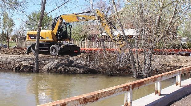
Bafford Lane is closed at the Carson River. NDOT and local agencies cut sections of the road and riverbed embankment at the Bafford Lane bridge on Wednesday to allow increased flow of the Carson River as part of coordinated local flood mitigation measures. Access to Bafford Lane on either side of the river will remain available to local traffic via U.S. 95 or Indian Lakes Road.
The Bafford Lane bridge will be closed for an indefinite amount of time.
FLOOD ADVISORY
Truckee-Carson Irrigation District (TCID) officials are reporting increased releases out of Lahontan Reservoir with the water continuing downstream along the Carson River. Bafford Lane Bridge may be closed for the next 4 to 6 months based on information from law enforcement officials. In addition, the increased flows may bring minor flooding to some yards of homes along the river, but homes are not anticipated to flood at this time. Macari Lane east of Schaffer Road remains closed at the Grimes Slough.
Prolonged high flows are occurring on the Carson River due to the necessary drawdown of Lahontan Reservoir. This has been coordinated by the TCID and local emergency management officials to create storage space for anticipated high snowmelt flows later this spring. These flows are expected to continue for an extended period of time.
Many channel improvements were completed ahead of the initiation of the necessary drawdown. These improvements are allowing higher flows to pass with limited impact.
PRECAUTIONARY/PREPAREDNESS ACTIONS...
Minor flooding is currently being reported in a few isolated locations, while the river remains bankfull in other locations. Any unanticipated increase in flows or changes to the river channel could lead to additional flooding in areas immediately adjacent to the river. Flows will be continuously monitored and will be adjusted as much as possible to minimize potential flooding impacts.

Comments
Use the comment form below to begin a discussion about this content.
Sign in to comment