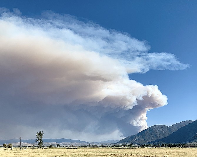
A pyrocumulus cloud rises above a fire burning in Alpine County west of Markleeville.
Steven R Graboff | Special to The R-C
Evacuations for the Tamarack Fire have been confirmed for Markleeville, Grover’s Hot Springs Park and Campground, Shay Creek, Marklee Village and the East Fork Resort.
Residents may sign up for evacuation notifications at at https://alpinecountyca.gov/204/Sheriff. Evacuees can report to Alpine County School in Paynesville. The public is advised to avoid the area. Visit https://inciweb.nwcg.gov/incident/7674/ for continued updates.
The Tamarack fire is estimated to be 500 acres burning near the town of Markleeville. Firefighters are on scene and actively engaged in suppression operations. Two helicopters, very large air tanker, single-engine air tankers and air attack are on scene. Fire is burning in timber and brush. Fire is active on flanks and exhibiting high rates of spread.
"Ground and air resources have been working together to establish an anchor point to begin containment lines around the flank, or sides, of the fire," officials said. "Currently, air tankers are using retardant to coat the vegetation to try to inhibit the fire’s spread. A Type 2 Incident Management Team has been ordered for this incident."
Organizers have canceled the annual Death Ride Tour of the California Alps due to the Tamarack Fire burning toward Markleeville, according to the event’s web site.
Any riders currently staying in the Markleeville area are asked to evacuate.
There are reports that Markleeville, home to around 200 people, is under an evacuation order. An evacuation Center has been set up at the Early Learning Center at 100 Foothill Road.
Evacuations are underway as the Tamarack Fire has burned to within a quarter-mile of Markleevillage.
The fire grew from 37.5 acres to 500 acres as of 6:30 p.m. It was burning six miles southwest of Markleeville, according to fire Spokesman Brandon Hampton
He said evacuations were announced over Reverse 911.
A hotshot crew and two helicopters are fighting the fire, with four additional crews and air tankers on order.
“Due to the complexity of the fire, a Type Two Management Team will be here Saturday,” he said.
Previous Story: A big cloud of smoke rising above the Sierra due south of Carson Valley could be coming from either the 1,040-acre Henry Fire or the 37.5-acre Tamarack Fire, which is burning near Pleasant Valley southwest of Markleeville.
Or it could be coming from both of them.
Both fires have been burning for some time without producing large amounts of smoke.
The Tamarack Fire burning along Blue Lakes Road started July 4 and has been monitored by firefighters.
The Henry Fire has been burning since it was set by lightning back on June 16 but has been burning slowly until this week when it more than tripled in size.
Alpine County Public Health Officer Richard Johnson reported smoke was clearly visible over Markleeville at 2 p.m. Friday.
He said smoke from the fires in Markleeville were in the moderate range.
“Actual levels at higher elevations are likely to be higher,” he said.
Alpine County is expecting as many as 2,100 riders for the annual Death Ride on Saturday.
“It is difficult to predict conditions for the race,” Johnson said. “However, it is safe to say there will still be smoke at some level still blowing through the area on Saturday.”
He suggested that individual sensitive to smoke should reduce prolonged or heavy exertion.
“This is typically a very small group of people and may not include anyone who is a participant in the Death Ride,” he said. “However, spectators and volunteers are more likely to fit in this category.”
Comments
Use the comment form below to begin a discussion about this content.
Sign in to comment