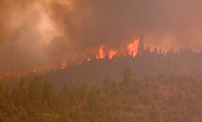
Flames can be seen from Highway 88 near Paynesville as they crest the ridge between Woodfords and Indian Creek Reservoir.
Photo by Kurt Hildebrand.
Strong winds drove the Tamarack Fire to 21,281 acres as residents evacuated from Woodfords watched the flames burn over the ridge line above Indian Creek Reservoir.
Additional personnel were headed to Woodfords, including a BLM strike team traveling north.
The fire has jumped Highway 89, and the town of Markleeville is surrounded by the fire, according to mapping on Nevada Fire Information. Two structures are confirmed lost to the fire.
“Forced by gusty winds, critically dry fuels and low relative humidity, the Tamarack Fire exhibited rapid rates of spread and an increase in fire behavior throughout the day,” fire officials said. “The fire is estimated to have grown to 21,000 acres today and is still zero percent contained.”
The fire crossed the East Fork of the Carson River near the East Fork Resort and into lighter fuels which sped the fire’s growth north this afternoon.
“This evening, firefighters will continue to actively suppress the fire where they can safely do so using a variety of tactics, natural barriers and targets of opportunity. The fire continues to impact the community of Markleeville and the surrounding area.”
Incident command for the fire moved from Turtle Rock Park to Douglas High School in Minden, while the evacuation center set up at the Early Learning Center in Woodfords has moved to the Douglas County Community & Senior Center in Gardnerville.
Visibility was down to three miles at Minden-Tahoe Airport for four hours until around 3:15 p.m. when the wind started to clear out the smoke. Low visibility reduced the support aircraft could provide during much of the day.
The wind picked up this afternoon with a 34-mph west-southwest gust reported at Markleeville at 1:48 p.m. Winds gusting around 30 mph were recorded every hour since.
Winds helped clear some of the smoke out of Carson Valley with air quality increasing to unhealthy for sensitive groups. Air quality is forecast to be unhealthy on Sunday.
Fuel moisture is 4 percent, meaning the timber around the Alpine County seat is tinder dry.
Evacuations in Alpine County have expanded to Crystal Springs, Alpine Village, Diamond Valley Road and Hung-a-lel-ti Washoe Tribal Colony as the Tamarack Fire increased in size to 15,000 acres.
The evacuation center is moving to the Douglas County Community & Senior Center in Gardnerville.
Heavy smoke is reducing aid from aircraft over the fire burning around Markleeville.
Alpine County issued an update saying that the Mesa is under voluntary evacuation, but fast-moving conditions could change that soon.
Alpine confirmed that two structures have been lost in the fire.
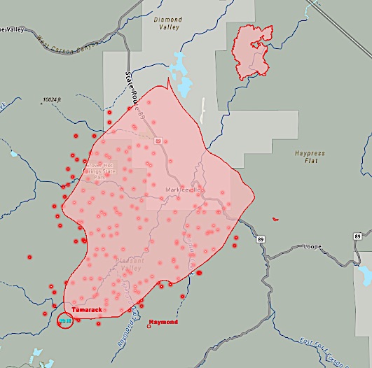 The extent of the Tamarack Fire as of Saturday evening. The East Fork Fire burn area is located northeast of the fire.
Liberty Utilities reports electricity is out to 202 customers in Alpine County.
Reports are that the incident command is being moved from Turtle Rock Park in Alpine County to Douglas High School in Minden.
The Tamarack Fire is generating heavy smoke as it continues to burn north.
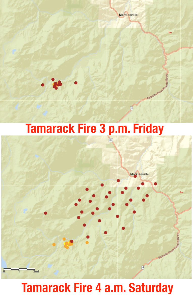
The fire grew from fewer than 40 acres on Friday morning to 6,600 acres as of 8 a.m. Saturday, after burning actively through the
night. Containment is at zero percent.
“(The) fire is active on all flanks and exhibiting high rates of spread. Ground and air resources have been working together to establish an anchor point to begin containment lines around the flank, or sides, of the fire,” fire officials reported at the Inciweb site for the fire. “Currently, air tankers are using retardant to coat the vegetation to try to inhibit the fire’s spread."
Fire officials said firefighters will focus on handling construction supported by aircraft today with the goal of keeping the fire from spreading toward structures and unburned areas.
Structure protection fire engines from surrounding agencies with support from wildland fire engines will fight the fire as it encroaches into Markleeville and the surrounding areas.
"A local hotshot crew will utilize suppression tactics to take advantage of natural barriers and areas of opportunity to increase the containment throughout the burning period," officials said.
The Tahoe Douglas Fire District Zephyr Fire Crew was among the fire resources responding to the blaze on Saturday morning.
The fire exploded to life on Friday afternoon after smoldering for nearly two weeks after it was set by a lightning strike. It was first reported 4 p.m. July 4 and might have been from the same electrical storm that set the East Fork Fire a few days earlier.
The fire is burning in heavy timber and brush, pumping smoke into Carson Valley with ash falling as far away as Minden and Genoa.
Air quality was at very unhealthy levels as of 8 a.m. Saturday and is expected to get worse.
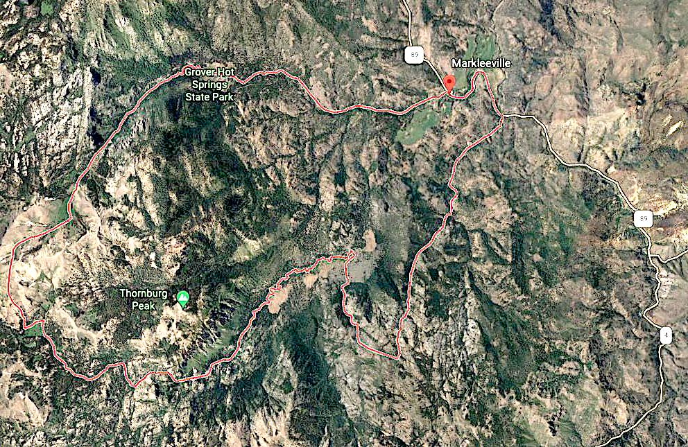 The boundaries of the Tamarack Fire on Saturday morning.
Previous story
While no updated size or report of structure loss has been issued this morning, mapping of the Tamarack Fire online indicates the fire made it to Markleeville, with a hotspot indicated on the hill where Highway 89 climbs out of town and another north of town.
The town of around 200 people was evacuated last night as the fire loomed.
While at last report, the fire was 500 acres, it is easily five times that according to maps appearing on both the Nevada Fire Information and the National Fire Situational Awareness web sites.
 Both the Hawkins Peak and Bald Mountain fire cameras showed flames through the night.
Highway 89 is closed from the junction with Highway 395 all the way to Turtle Rock Park, where an incident command has been set up.
A smoke plume was visible from all over Western Nevada on Friday evening, prompting a handful of calls from residents who thought it was much, much closer.
Smoke from the fire drove air quality in Carson Valley down to unhealthy for sensitive groups early Saturday morning.
The fire resulted in the cancelation of the annual Death Ride, which was scheduled to start 5 a.m. today.
Alpine County authorities are urging residents to sign up for emergency alerts rather than rely on social media for information.
Residents can sign up for evacuation notifications at https://alpinecountyca.gov/204/Sheriff. Evacuees can report to Alpine County School in Paynesville. The public is advised to avoid the area. Visit https://inciweb.nwcg.gov/incident/7674/ for continued updates.

Comments
Use the comment form below to begin a discussion about this content.
Sign in to comment