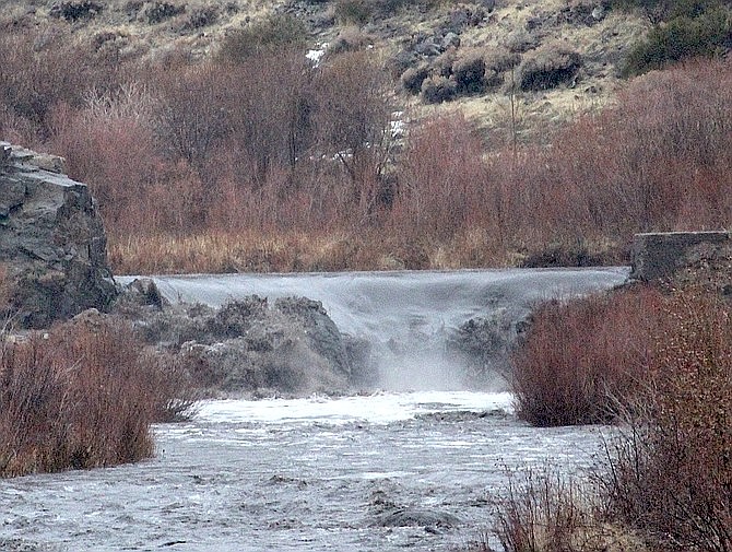
The East Fork of the Carson River shown in Gardnerville on Dec. 27, 2022.
Photo by Kurt Hildebrand.
This story was updated at 4:50 p.m. on Wednesday, Dec. 28.
The National Weather Service has issued a flood watch for Carson City and other areas from Friday morning through Saturday evening as projections show the Carson River reaching flood stage over New Year’s weekend.
The NWS is forecasting a potent atmospheric river system to hit areas already saturated from storms earlier in the week.
“(This) could allow for significant rises on both mainstem and smaller rivers and streams, rock falls in steep terrain, urban flooding, and flooding in low-lying areas or poor drainages,” the NWS said. “In addition to the flood watch, we also issued a winter storm watch for northeast California, the Sierra Nevada including the greater Lake Tahoe area, and Mono County for heavy snowfall mainly above 7,000 feet.”
Before the larger storm arrives Friday, a smaller system will produce light snow showers on Thursday. An inch or less of snowfall below 6,000 feet is possible for western Nevada, according to the NWS.
Friday morning, a weak warm front will raise the snow level to 8,000 feet. Valley rain and mountain snow are expected throughout the day. Mountaintop winds could reach 100 mph.
Saturday morning, the atmospheric river opens in full. The snow level is likely to remain high, and valleys in western Nevada could see 1.5 to 3 inches of rain. Snow levels are expected to drop near valley Saturday night.
“After our recent heavy rains, many watersheds have been primed and will be more prone to flooding with the prolonged and heavy rain expected Friday and Saturday,” the NWS said. “We are also expecting major rises on mainstem rivers with minor to moderate flooding possible especially on the East Fork of the Carson near Gardnerville, the Carson near Carson City, the Susan River near Susanville, and the Pit River in Big Valley.”
On Wednesday afternoon, hydrologic models from the National Oceanic and Atmospheric Administration showed the river in Carson cresting at 10.5 feet by Sunday morning. Flood stage is 10 feet.
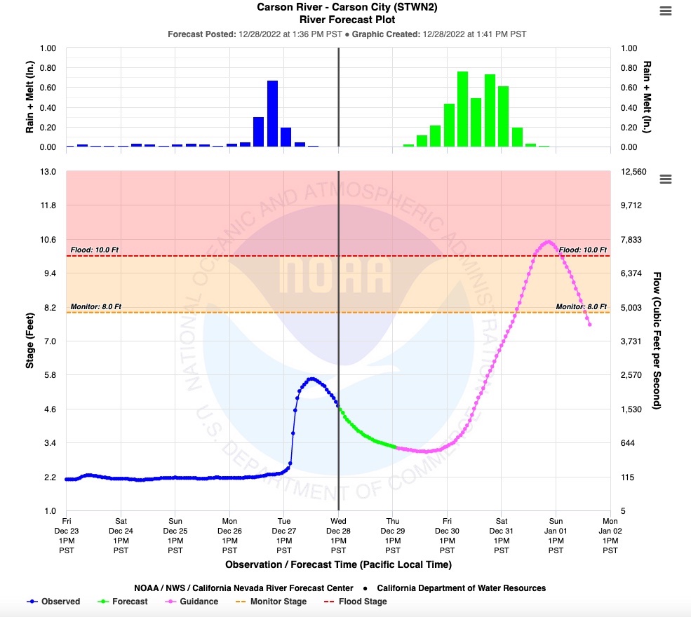 National Oceanic and Atmospheric Administration showing the Carson River projected to hit flood stage by Sunday.
 “Due to the ground already being saturated, the city is planning on flooding associated with the upcoming storms and will be ready to address issues as they materialize,” said Rick Cooley of Carson City Public Works. “At this point in time, predictions are still a moving target as to timing and intensity, but our crews have been out since this last storm working on known problem areas and preparing for rain this weekend and snow next week.”
Cooley urged resident to keep drainages clear.
“Our citizens are the first line of defense by keeping drainages clear,” he said. “They are in a position to see potential drainage issues around their home and neighborhood on a daily basis.”
Cooley said residents with recurring drainage problems should have sandbags on-hand before the storm arrives.
“Carson City residents can take advantage of the sandbag filling station at 3505 Butti Way (west of the main building and parking lot),” he said. “Sand and bags are provided at the station; however, you will need to bring your own shovel.”
Lyon County officials are also reminding residents to be prepared, pointing to several sandbag locations set up.
“Each sandbag location has sand and bags to fill; bags are located in the brown bear box at each site,” officials said in a press release. “Residents must bring their own shovel as the county doesn’t have any at the fill locations.”
Sandbag locations in Lyon County include:
• Mound House Fire Station - 56 Red Rock Road, Mound House
• Silver City Community Center - 385 High St., Silver City
• Fire Station #39 - 460 Dayton Valley Road, Dayton
• Dayton Valley Road, just southwest of Sutro Road
• Fire Station #35 - 231 Corral Drive, Dayton
• Stagecoach Community Center - 8105 U.S. 50, Stagecoach
• Silver Springs JPO Office - 1075 Pyramid Ave., Silver Springs
Officials said residents should keep extra supplies on hand, such as food, water, first aid kits, blankets and flashlights with batteries.

Comments
Use the comment form below to begin a discussion about this content.
Sign in to comment