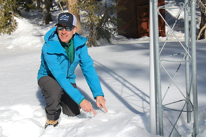
Jeff Anderson, hydrologist for NRCS Nevada, points out two holes where he has measured the snowpack. One was fresh, and the other was from his last measurement Jan. 10. He said that in his years of measuring snowpack, he has never seen a sample hole remain intact for so long. (Photo: Faith Evans/Nevada Appeal)
It’s the driest January in decades for the eastern Sierra basins. Jeff Anderson, a hydrologist for the Natural Resources Conservation Service, can still see the holes and tracks he left when he took snowpack measurements at Mt. Rose on Jan. 10.
“Pretty much all of the snow that’s here fell in December,” he said at the Mt. Rose Ski Area Snowpack Telemetry site Monday.
The location had 77 inches of snow with almost 27 inches of water content. That’s still above average for January, but without more winter storms, it may soon dip below annual trends.
“If we don’t get any more snow for the year, this site is 72 percent of normal for the whole year,” Anderson said.
Usually, January adds 12-13 inches of snow water to the Mt. Rose SNOTEL, but this month, the snow has lost over half an inch of its water content.
“In the last month with all this dry weather and the blue sky we’ve actually seen some of the water content in the snowpack sublimate. … It’s kind of like evaporation, but you go straight from solid to a gas,” Anderson said.
The upside is because October 2021 saw so much precipitation, the soil underneath the snow is wetter than normal. When the snow does melt, more of it will reach streams, lakes and reservoirs rather than soaking into the ground.
Anderson said there are two scenarios for the snowpack forecast this year, based on similar trends from 2011 and 2013.
Both years had a heavy December with a dry January. In 2011, storms rolled in after Valentine’s Day and helped the season end with 176 percent of the average snowpack. In 2013, the opposite happened. The region saw very little snow after Jan. 1, and only secured 71 percent of its normal snowpack.
“We really could use more snow to get that number well above 100 percent. … We’ll be here to measure it if it falls,” Anderson said.
The most accurate forecasts only predict up to 10 days of weather. Thus far, the beginning of February is looking just as dry as January.

Comments
Use the comment form below to begin a discussion about this content.
Sign in to comment