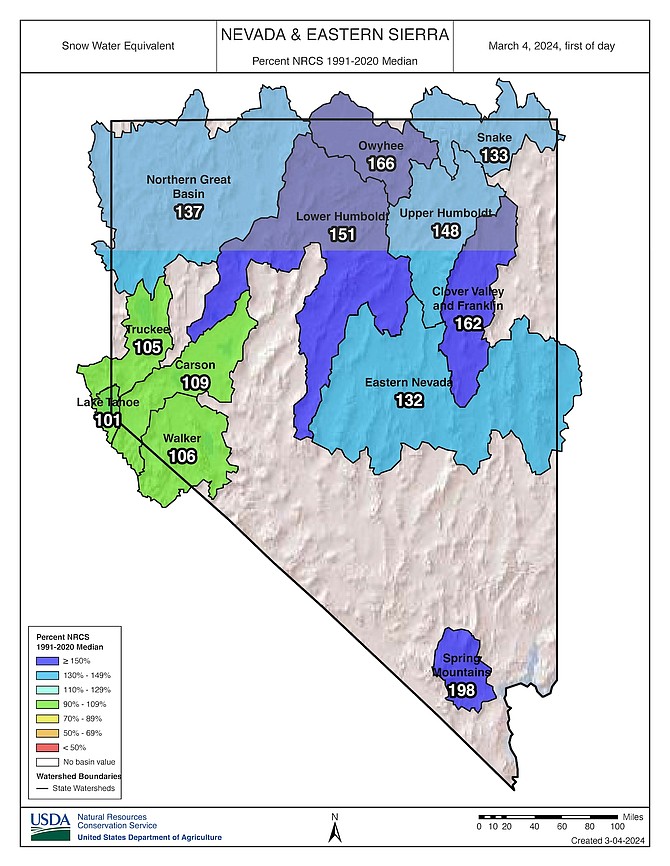
A U.S. NRCS map from March 4, 2024, showing percent of median for the date of snow water equivalent in Nevada basins.
Big storms in the Sierra Nevada can make or break the region’s snowpack. Case in point: the wet storm that landed Friday morning and lasted through the weekend boosted the snowpack to normal for this time of year, according to data by the U.S. Natural Resources Conservation Service (NRCS).
“Compared to where we were on Jan. 1, this is an incredible comeback for sure,” said NRCS Nevada Hydrologist Jeff Anderson. “Things can turn around quickly in the Sierra. One storm can make a big difference.”
Anderson said the latest storm likely ranks in the top six biggest storms for the Tahoe Basin. The storm created 7.4 inches of snow-water equivalent in the Tahoe Basin between Thursday and Monday, he said.
At midnight on Thursday, the Lake Tahoe Basin was at 73 percent of median snow water equivalent for the date. The Truckee River Basin was at 74 percent, the Carson River Basin at 81 percent and the Walker River Basin at 76 percent, according to Anderson.
By Monday morning, each of those basins had seen double-digit jumps in percentage of snow water equivalent: Lake Tahoe hitting 101 percent of median for the date, Truckee reaching 105 percent, Carson 109 percent and Walker 106 percent.
“Almost 30 percent to do that,” said Anderson. “To do that in March, when we’re already 3-4 months our way through winter, just tells you how big of a storm (it was).”
Anderson noted some Nevada locations received more snow than the west shore of Lake Tahoe. Little Valley, between Washoe Valley and Diamond Peak, saw more than four feet of snow from the storm.
However, many snow totals for March are still behind the springtime peak levels that typically occur in April. For instance, as of Monday, a snow telemetry site at Mt. Rose Ski Area had 32 inches of snow water equivalent, which was 101 percent of the median for the date but only 86 percent of the springtime median peak of 37.4 inches.
“If we get another decent storm, we’ll probably be there,” Anderson said.
The basins across Nevada have fared even better than the Sierra, receiving storms from the Northwest the Sierra has missed, Anderson said. As of Monday, the Northern Great Basin was at 137 percent of snow water equivalent median for the date, while the Spring Mountains in the southern Nevada were at 198 percent.
A decent 2024 winter on top of 2023’s epic snowfall adds up to wetter forests and more water in the reservoirs of the Sierra region, Anderson said. March snow, especially banked on lower slopes, shortens the fire season, he said.
“In terms of fire, it’s good for us to have a normal snowpack this time of year,” he said. “Hopefully, the dry season, the snow-free season, is shorter. The forests have a good amount of snow in them.”
This will mean a shorter period for fuels to dry out, he said.
The west side of Carson City recorded between 12 and 14 inches of snow depending on location and wind. That was on top of the 1.9 inches of rain that was recorded.
Monday, piles of plowed snow sat shrinking in parking lots around Carson Street. Sheriff Ken Furlong said there were no major wrecks over the weekend from the snowfall.
“Nothing major in Carson,” he reported.
To check road conditions, visit https://www.nvroads.com/.

Comments
Use the comment form below to begin a discussion about this content.
Sign in to comment