When it comes to living off the grid, it doesn’t get much more remote than the tiny central Nevada enclave of Kingston.
Located 27 miles southeast of Austin, in nearly the geographic center of the state, the town of Kingston, which sits at the mouth of Kingston Canyon, describes itself as the Gateway to the Toiyabe Mountains — which it is.
To reach the community, travel 17 miles east on U.S. 50 to State Route 376, then south for about four miles to Kingston Creek Road, which leads into the canyon.
For visitors, there really are two Kingstons: the more recent development near State Route 376 and the historic remains of a mining settlement, found deeper into Kingston Canyon.
The more contemporary Kingston, which has a population of about 113 people, consists of a few dozen ranch homes and a handful of larger buildings.
The town’s primary businesses (at least at this time) include a general store and Zach’s Lucky Spur Saloon, a friendly old-time watering hole. Until recently, Kingston also boasted the Miles End B & B, a quaint and rustic bed and breakfast, which closed for remodeling and then due to COVID restrictions. It’s unknown when and if it might reopen but the owners have posted a few messages on the Yelp website (www.yelp.com/biz/miles-end-bed-and-breakfast-kingston).
If you drive past the newer development, you begin the climb up Kingston Canyon. A few miles ahead and to the right are the last remnants of the historic mining district of Kingston, which was settled in the mid-1860s, following the discovery of silver in the mountains above (at a place called Bunker Hill).
In 1865, Kingston got a post office and a 20-stamp mill, the Sterling Mill, was erected on the hillside above the settlement. Records indicate a few other mills were built in subsequent years, making Kingston an important milling center for the mines in the area.
Within a few years, however, all the activity began to decline. The post office closed in 1869 and most of the mills were closed.
In 1881, mining activity resumed in the canyon, which revived the town, now known as Morgan. A post office (called Morgan) opened in November of that year.
Unfortunately, Morgan had about as much success as Kingston, and the town entered another decline in 1885. The town experienced one last gasp at life, from 1906 to 1911, before the mining industry abandoned the area for good.
Despite the ups and downs, a handful of people remained in Kingston, which even boasted its own school until the mid-1920s. Starting in the 1970s, Kingston began aggressively promoting itself as a retirement community and peaceful retreat, which served as the basis for the current population.
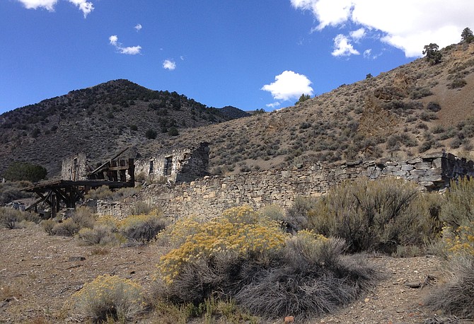
The best survivor of the original Kingston mining development is the former Sterling Mill, which consists of fairly substantial stone walls and large timbers. Around the mill site, there are also the scattered foundations and walls of other structures no longer identifiable.
From the mill site, you can start driving up on a maintained dirt road into Kingston Canyon. The canyon walls offer some impressive rock formations and classic Nevada pinion and sagebrush landscape.
The road rises above the surrounding Big Smoky Valley — offering a wonderful view — into the Toiyabe Range. About a mile from the canyon entrance, you reach the rustic Kingston Canyon Campground, operated by the National Forest Service.
A bit farther is a pretty, small reservoir, a popular local fishing spot. From here, the road curves around Bunker Hill (the 11,474-foot-high peak to the north, where silver was first discovered) and rides the crest of the Toiyabe range for a few miles, paralleling Kingston Creek.
The scenery here is memorable; to the west, you can see the beauty of the Reese River Valley, while to the east is the spectacular Big Smoky Valley. A few miles ahead, Kingston Creek Road becomes Big Creek Road and reaches the Big Creek Forest Campground, a relatively undeveloped backcountry campsite.
The road continues northwest from the campground, dropping down into the Reese River Valley at a point about 10 miles south of Highway 50 and Austin.
For information about Kingston, go to
www.landercountytourism.com/kingston or
https://travelnevada.com/travel-guides/kingston/.
Rich Moreno writes about the places and people that make Nevada special.

Comments
Use the comment form below to begin a discussion about this content.
Sign in to comment