The first of December is expected to bring between 2-6 inches of snow to Carson City on Thursday and Friday.
The National Weather Service has issued a winter weather advisory for 4 p.m. Thursday to 4 a.m. Friday.
The storm is expected to drop up to 2 feet of snow above 7,000 feet and 10 to 20 inches at lake level. The warning is in effect from 10 p.m. Wednesday to 10 a.m. Friday for Lake Tahoe.
Officials are urging motorists to avoid traveling the mountain passes due to snow and wind. Winds will reach up to 45 mph with gusts near or above 100 mph over Sierra ridgetops.
Travel during the warning will be difficult with hazardous conditions impacting the morning and evening commutes. Strong winds could cause damage to trees and lead to power outages.
The heaviest snowfall rates are anticipated Thursday and could reach 3 inches per hour. The combination of heavy snow and strong winds may lead to whiteout and hazardous driving conditions.
For road conditions, check with Caltrans at quickmap.dot.ca.gov and NDOT at nvroads.com.
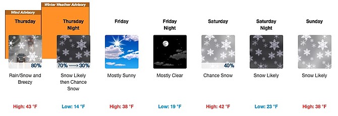
Carson City forecast:
Thursday forecast: Rain and snow, becoming all snow after 2 p.m. Snow level 4,900 feet. High near 43. Breezy, with a southwest wind 20 to 25 mph, with gusts as high as 45 mph. Chance of precipitation is 80%. New snow accumulation of 1 to 3 inches possible.
Thursday night forecast: Snow likely, mainly before 11 p.m. Mostly cloudy, with a low around 14. Southwest wind 5 to 10 mph, with gusts as high as 20 mph. Chance of precipitation is 70%. New snow accumulation of 1 to 3 inches possible.
Friday forecast: Mostly sunny, with a high near 38. Southwest wind around 5 mph.
Friday night forecast: Mostly clear, with a low around 19. Southwest wind around 5 mph.
Saturday forecast: A 40 percent chance of snow, mainly after 11 a.m. Partly sunny, with a high near 42. New snow accumulation of less than one inch possible.
Saturday night forecast: Snow likely. Mostly cloudy, with a low around 23.
Sunday forecast: Snow likely, mainly before 11 a.m. Mostly cloudy, with a high near 38.
Sunday night forecast: A chance of snow, mainly before 11 p.m. Mostly cloudy, with a low around 16.

Comments
Use the comment form below to begin a discussion about this content.
Sign in to comment