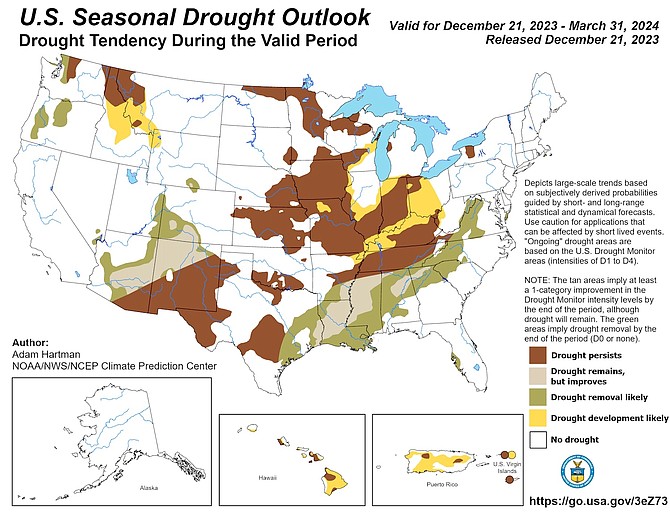
A map from the National Weather Service, released Dec. 21, estimating no drought for most of Nevada and California through March 31.
Even with winter off to a slow start, the Carson City region is not facing drought in the near future.
According to Dec. 21 projections from the National Weather Service’s Climate Prediction Center, no drought is foreseen for the vast majority of Nevada and California through March 31.
“It takes more than one or two dry months flipping (us) into a drought status when we are coming off a very wet year,” said Mark Deutschendorf, meteorologist for NWS in Reno.
The new water year began Oct. 1, and Deutschendorf put the Tahoe Basin around 46 percent of normal snowpack as of Dec. 26. The Carson River Basin was around 42 percent of normal. At Carson Pass, there were three inches of snow water equivalent (the amount of liquid in the snowpack) versus the normal of nine inches for this time of year, according to Deutschendorf.
“It’s a slow start,” he said. “There is still a lot of winter to go. We still got three months of winter potential to hopefully catch up.”
The meteorologist said he expects a higher-than-normal chance for precipitation in January, February and March based on Dec. 21 projections.
“It would be in line with a typical El Nino pattern,” he said, noting a “pretty strong El Nino signature” in the Pacific Ocean.
Deutschendorf pointed to a storm system expected over New Year’s weekend that’s comparable to storms earlier this month. While it could bring snow to the high mountains, “the valleys look to be still light rain or nothing.”
“It’s a waiting game out there,” he said.

Comments
Use the comment form below to begin a discussion about this content.
Sign in to comment