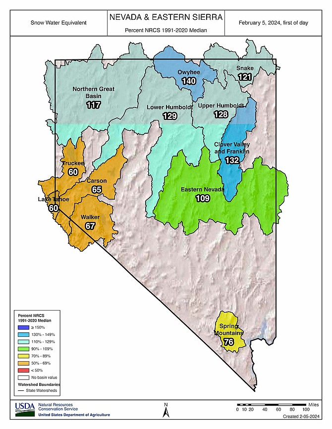
A map from the USDA Natural Resource Conservation Service showing percent of median for snow water equivalent in Nevada basins.
The snowstorm that dumped more than a foot of snow in Carson City on Sunday boosted the lagging Sierra Nevada snowpack, but it didn’t get the region up to normal for this time of year, according to the USDA Natural Resources Conservation Service.
“It’s definitely a step in the right direction,” Jeff Anderson, NRCS Nevada hydrologist, said Monday morning.
However, Anderson said the Sierra region typically needs about five atmospheric-river storms in a season to reach a normal snowpack by springtime. Sunday’s storm was the first major one this year. He said in comparison, the 2023 winter had 15 atmospheric-river storms leading to record snowpack.
“They enter the California coast at different places,” he said.
In the current El Nino pattern in the Pacific, the Sierra has about a 1 and 3 chance of seeing a big winter, Anderson said. It has about the same odds for a normal winter or a below-average winter, depending on how the storms shift. Anderson said the region needs four more atmospheric rivers by the end of March for a normal snowpack.
As of Monday morning, snow water equivalent — how much water content resides in the snowpack — was at 60 percent of median in the Lake Tahoe and Truckee River basins, 65 percent of median in the Carson River Basin and 67 percent in the Walker River Basin, according to various NRCS snow telemetry sites.
Ebbetts Pass, for example, feeds the East Fork of the Carson River and had 15.4 inches of snow water equivalent Monday, which is 65 percent of the median for the date and only 44 percent of the peak springtime median of 35.1 inches.
Other parts of the Silver State, including the north and eastern stretches, were over 100 percent of median in snow water equivalent on Monday, but the Sierra Nevada has been off to a slow start. Anderson noted the U.S. Drought Monitor’s latest update showed the Carson region slipping back into abnormally dry conditions. Sunday’s storm did help, he said, with snow water content in the Carson River Basin jumping 16 percent since Feb. 1.
“If they (atmospheric rivers) start lining up like they did last year, we can catch up in a hurry,” he said.
The National Weather Service forecast more snow showers throughout the week but with little accumulation on valley floors expected.
The good news, according to Anderson, is last year’s epic winter filled area reservoirs that can last through a less-than-stellar snow season this time around.
“Our reservoir storage is good right now from all the water we had last year,” he said. “If you look at Walker and lower Carson and the amount of water storage we have, we don’t need a huge winter hopefully to get those reservoirs topped off.”
Anderson said a normal snowpack this year is still possible.
“If we get another couple atmospheric rivers and a few more smaller storms sprinkled in, that could be where we end up,” he said.
Comments
Use the comment form below to begin a discussion about this content.
Sign in to comment