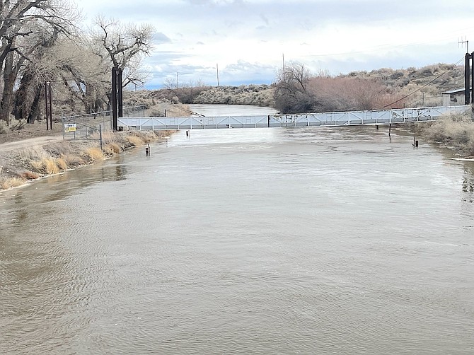
A fully charged V-line canal carries water from the Diversion Dam west of Fallon.
Photo by Steve Ranson.
Actual flood mitigation efforts in Churchill and surrounding counties began last week when the Truckee-Carson Irrigation District opened the V-line weir to send water into the desert and eventually to the Stillwater National Wildlife Refuge via the “Big Dig” canal.
TCID Water Master Kelly Herwick said the big concern this month has been with the atmospheric river, which is a long corridor of concentrated moisture in the atmosphere that can produce heavy rain over a wide area.
Herwick told the Lahontan Valley News that a major difference between the big water year of 2017 and this year are the snowfall trends.
“Below 6,000 feet elevation, the snow is accountable; it’s more of a widespread snow,” he said.
The atmospheric river is not going away anytime soon. Herwick said the weather models are calling for more rain.
Herwick also gave some unsettling news similar to what county residents faced six years ago. The water content of the snowpack is holding about 500,000 to 600,000 acre feet of water, which is equivalent to two Lahontan Reservoirs.
“Two lakes – that’s worrisome,” Herwick said.
The reservoir’s capacity is about 295,000 acre-feet with one acre-foot equaling about 326,000 gallons. An acre-foot would cover a football field with water one-foot deep.
Before TCID re-routed the water from the V-line weir, Herwick said Carson Lake south of Fallon was about one-third full. What’s helping TCID and Churchill County this year is infrastructure. The weir, the Big Dig ditch and more efficient culverts, which were replaced in March 2017 under U.S. 95 between Dodge Lane and the turnoff to the Top Gun Raceway, are in place, thus saving construction time.
Herwick said silk has been removed from the channels that lead to the highway, which provide for a more efficient flow rate.
“The culverts are in good shape,” Herwick said. “We can send flows of 1,200 cfs. There’s plenty of room to get (the water) out there.”
Cfs is described as “the flow rate or discharge equal to one cubic foot (of water, usually) per second. This rate is equivalent to approximately 7.48 gallons per second.”
Another concern is Bafford Lane, which was closed in 2017 when a portion of the bridge was removed as not to impede the river flow.
“We don’t need to cut the road, but we're watching the road and levels,” Herwick said. “The (water) level is being monitored.”
Churchill County has also established an area for filling sand bags on Miners Road across from the 3C Rafter arena.
State of Emergency declaration
Last week, Gov. Joe Lombardo declared a state of emergency because of the ongoing severe weather conditions in Churchill, Douglas and Lyon counties. One day later, he declared emergencies for the rest of the counties except for three. Locally, Pershing County was not under a state of emergency as of Monday.
Lombardo said in his emergency declaration the weather has brought heavy rainfall, flooding and infrastructure damage to the affected counties.
“As severe weather conditions continue, further flooding and infrastructure damage are anticipated throughout the region,” Lombardo said.
The declaration of emergency will enable the counties to receive state and federal assistance by protecting residents and repairing damage from the storms.
“I urge all Nevadans to stay safe, travel cautiously, and to follow all local guidance throughout the continuation of this severe weather,” Lombardo stated in his declaration.
Flood insurance
For those living in the floodplain and carrying flood insurance, local officials urge you to ensure your policies are up-to-date and active.
For those not carrying flood insurance, be aware that most regular homeowner’s policies do not provide coverage in the event of a flood. Many flood policies require a 30-day (or more) waiting period before becoming active. Ask your insurance provider for policies that fit your needs. The National Flood Insurance Program also offers resources.
Churchill County Emergency Operations Command officials believe that the high water concerns will continue throughout the spring and into early summer as the snow melts off the Sierra and comes into the Carson River via the reservoir.
Follow the Churchill County webpage at www.churchillcountynv.gov and click on the blue tab at the top for the latest announcements, resources and other information.
Information provided by Anne McMillin, Churchill County public information officer.

Comments
Use the comment form below to begin a discussion about this content.
Sign in to comment