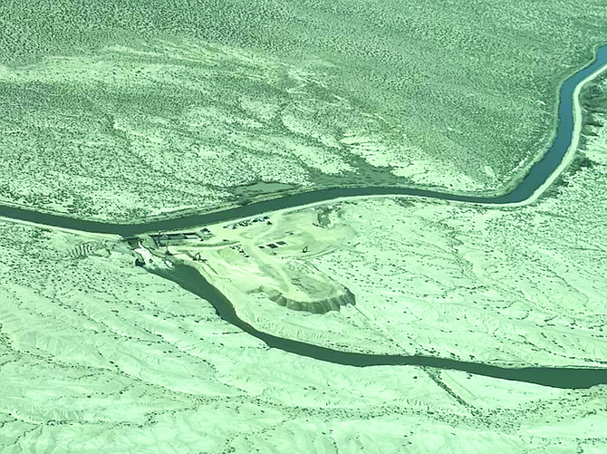
An overhead photo shows the first and second weirs on the V-line canal east of Fallon. The first weir opened in 2017, and Hughes Construction is currently building the second weir.
Pete Olsen
With construction underway on a second V-line canal weir, the city’s emergency manager and the county’s incident commander have been pointing out differences between the flooding six years ago and the potential for a similar event this spring.
Steve Endacott, Fallon’s emergency manager since 1994, and Caleb Cage, Nevada’s former director of Emergency Management, provided Fallon Rotarians last week with the latest update affecting the community.
Endacott provided a short history of the Lahontan Dam and canal system that winds through Churchill County. He said Lahontan Dam was constructed in 1915 and has passed stringent inspections since.
“It’s a very safe dam,” Endacott emphasized.
Once the Carson River flows downstream from the dam, he said the water is then separated into two major canals at Diversion Dam west of Fallon. The one canal currently on the county’s radar is the V-line, which is a major supplier of water to the area’s farmers and ranchers. He said the Carson River eventually flows into the Carson Basin northeast of Fallon.
Endacott said a weir and spillway were built on the V-line in 2017 to channel water into the desert through the Navy’s Bravo-16 range and eventually to the Stillwater National Wildlife Refuge via the Big Dig, a man-made 17-mile channel that transported the water from the Carson Lake southeast of Fallon to the marshes.
According to Endacott, former Churchill County Emergency Manager Ron Juliff proposed the construction of a weir to be used in critical situations. Within weeks in 2017, Endacott said Hughes Construction built the weir, and it was fully financed.
“The weir saved us in 2017,” Endacott added.
The Nevada Department of Transportation figured into the 2017 plan to send water south from the V-line. Endacott said NDOT installed culverts underneath U.S. 95 south between Dodge Lane and the Top Gun Raceway turnoff. The water flowed eastward toward the Carson Lake pasture.
NDOT also installed culverts under U.S. Highway 50 east of Fallon which allowed the water flowing into the Big Dig to continue its northeastern course toward the Stillwater marshes.
Endacott said the flood years have provided their own scenarios. During the 1996-97 flooding which occurred in December and early January, he said heavy rains melted a deep snowpack in the Sierra.
“It came down all at once,” Endacott said of the rain and melting snow into the area tributaries.
In 2017, Endacott said the Sierra Nevada received heavy snow, but when the forecast of rain and warmer weather was predicted for late winter and early spring, he said the water had nowhere to go. The need for a weir became critical because Endacott said Lahontan Reservoir already had 253,000 acre-feet of water, 47,000 acre-feet short of capacity. (An acre-foot equals one-foot of water spread out over an area such as a football field.)
As the state’s emergency manager on 2017, Cage said the weather alternated between rain and snow in early 2017.
“We had an atmospheric river coming over the Sierra and pouring rain on that snowpack,” Cage said, adding Northern Nevada had major flooding during the spring.
Cage said the second weir being constructed on the V-line is about three times wider than the first weir, and the banks of the V-line are being raised to accommodate extra water that will be released from Diversion Dam. He said water from both weirs will use the same spillway.
Cage also showed the current maps of the snowpack and projections for the snowmelt. In 2017, both Endacott and Cage said the Carson Basin contained enough water to fill two Lahontan Reservoirs or about 600,000 acre-feet. This year, they said there’s enough water to fill three reservoirs.
Need to know
• The water call center telephone number is 775-867-5923, and it will be staffed weekdays from 8 a.m. to 5 p.m. The dedicated email address is Highwater23@churchillcountynv.gov.
• Residents should use the email address or telephone number for non-emergency calls.
• High-water mitigation officials have created a new interactive flood modeling map which is now available on the city of Fallon and Churchill County websites. This map allows residents to enter their address in the top right-hand corner and pull up the flood modeling map for their home or business.
In addition, paper maps of the potential flood areas are posted at the main public entrance to the Churchill County Administrative Building, 155 N. Taylor St., in Fallon. This is the entrance at the corner of North Taylor and A Streets. The building is open to the public weekdays from 8 a.m. to 5 p.m. and residents are welcome to stop by to see the maps during those hours.
• Sandbags are only available for pick-up Mondays, Tuesdays and Wednesdays at the county’s Miners Road yard from 10 a.m. to noon and again from 12:30-4 p.m.
Websites to remember
City of Fallon: www.fallonnevada.gov
Churchill County: www.churchillcountynv.gov
Truckee River Operating Agreement (water reports): www.troa.net
Lahontan Valley News: nevadaappeal.com

Comments
Use the comment form below to begin a discussion about this content.
Sign in to comment