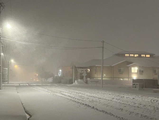
Carson City woke up to snow and wind early Saturday morning.
After receiving 1.89 inches of rain between Thursday and Friday, the winter storm switched to snow early Saturday morning.
By 5:30 a.m. Saturday, Carson City had received more than 3 inches but blowing snow made it impossible for exact totals.
The winter storm also knocked out power to 465 customers in Carson City and more than 250 in Douglas County. NV Energy didn’t have an estimation on when power would be restored.
The snow was expected to keep falling throughout the day. The winter storm warning continues through 10 p.m.
“Heavy snow likely. Snow accumulations 6 to 14 inches for valley floors, and 2 to 3 feet for Virginia City, the Virginia Highlands, and foothills above 5000 feet. Winds gusting as high as 55 mph,” National Weather Service Reno said.
Public works crews were plowing Carson City’s roads but driving on pavement wasn’t going to be in the forecast for some time. Unnecessary travel should be avoided as the storm is continue to drop snow throughout Saturday.
Travel on major highways and mountain passes require chains. I-80 over the Sierra was closed Friday and remained closed early Saturday.
The storm has impacted delivery of the Saturday print publication of the Nevada Appeal, to read the e-edition go here.
It is suggested drivers keep an extra flashlight, food, and water in vehicles in case of an emergency during the storm.
If travel was necessary the following links are recommended
• Nevada road conditions are available by calling 511 or go to nvroads.com.
• California road conditions are available at 800-427-7623 or go to quickmap.dot.ca.gov.
• Avalanche Info Sheet: https://www.ready.gov/sites/default/files/2021-01/ready_avalanche_info-sheet.pdf
• Emergency Supply Checklist: https://dem.nv.gov/uploadedFiles/demnvgov/content/Resources/FINAL%20Emergency%20Supply%20Kit.pdf
• Emergency Alert Notifications: https://dem.nv.gov/preparedness/Emergency_Alerts/
⚠️⚠️ UPDATE ⚠️⚠️
— CHP Truckee (@CHP_Truckee) March 2, 2024
(03/02/24 at 5:30am)
I-80 westbound traffic is still being turned around at the Nevada Stste line and eastbound traffic is being turned around at Colfax. No estimated time of reopening the freeway.
Extended forecast
Saturday
Snow, mainly before 10am, then snow showers after 1pm. Areas of blowing snow before 10am. High near 35. West wind 10 to 15 mph, with gusts as high as 25 mph. Chance of precipitation is 80%. New snow accumulation of 1 to 3 inches possible.
Saturday Night
Snow showers, mainly before 1am. Low around 22. West wind 5 to 10 mph. Chance of precipitation is 90%. New snow accumulation of 1 to 2 inches possible.
Sunday
A slight chance of snow showers before 7am, then a slight chance of snow showers after 4pm. Partly sunny, with a high near 37. West wind 5 to 15 mph. Chance of precipitation is 10%.
Sunday Night
A 20 percent chance of snow showers before 10pm. Mostly cloudy, with a low around 23. Southwest wind around 5 mph.
Monday
A 10 percent chance of snow showers after 4pm. Partly sunny, with a high near 43. Southwest wind around 5 mph.
Monday Night
A 30 percent chance of snow showers, mainly after 10pm. Mostly cloudy, with a low around 31. Little or no snow accumulation expected.
Tuesday
A chance of snow showers before 10am, then a chance of rain showers. Snow level rising to 5300 feet in the afternoon. Partly sunny, with a high near 46.
Tuesday Night
A chance of rain and snow showers before 10pm, then a slight chance of snow showers. Mostly cloudy, with a low around 29.
Wednesday
A slight chance of snow showers before 10am, then a slight chance of snow showers after 4pm. Partly sunny, with a high near 43.
Wednesday Night
A slight chance of snow showers. Partly cloudy, with a low around 21.
Thursday
Mostly sunny, with a high near 43.
Thursday Night
Mostly clear, with a low around 19.
Friday
Sunny, with a high near 46.

Comments
Use the comment form below to begin a discussion about this content.
Sign in to comment