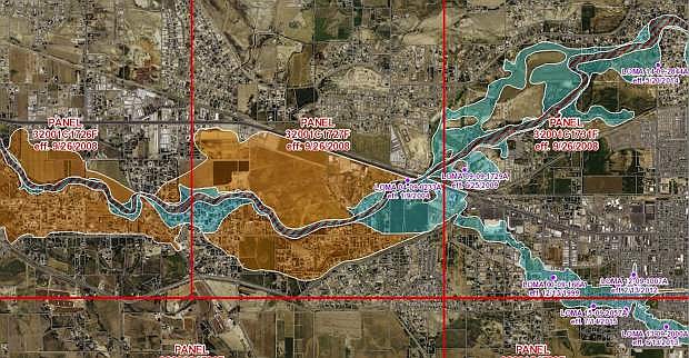
This map shows the aeas that could be affected by flooding. Go to http://arcg.is/2pmimj5 to see if your home is in the Churchill County Flood Plain.
The National Weather Service extended a flood advisory that expired Wednesday to continue at least through July.
Meteorologist Scott McGuire told the LVN on Wednesday the snowpack is still substantial in four major recording areas of the Sierra Nevada. McGuire said the rivers in western Nevada will be extremely dangerous because of the cold water. He said the fire departments in Reno and Sparks have already rescued several people from the Truckee River.
“We’re carrying a significant snowpack into May,” McGuire said, adding the majority of snowmelt will occur within the next two months.
Churchill County Sheriff Ben Trotter issued a warning on the sheriff’s office’s Facebook page.
“The water in the river and the canals is going to be running at capacity for the foreseeable future,” he wrote. “This makes for a dangerous situation for anyone playing in or around these areas. People and pets should use caution.”
Northern Nevada has experienced cooler-than-normal weather this week with some precipitation, but McGuire said the temperatures will warm up this weekend into next week.
As of this week, the snow depth in the Lake Tahoe Basin is 338 percent of normal and contains 57 inches of snowmelt water. The Truckee River Basin is at 260 percent with 93.4 inches of water recorded at the SNOTEL station at Mt. Rose.
The Carson River Basin shows the snowpack at 262 percent above normal with the water content at 80.2 inches.
The Walker Basin, which feeds water to Walker Lake north of Hawthorne, is at 255 percent with about 121.7 inches of water content. The United States Geological Service predicts Walker Lake could rise by as much as 15-feet by mid-to-late summer.
The Churchill County Emergency Management team has identified at least five areas that are vulnerable to some river flooding based on discussion with state and government agencies. Incident Commander Bill Lawry said those areas include River Village, Santa Fe Drive, McLean and Alcorn roads and Bafford Lane where Churchill County, the Nevada Department of Transportation and Truckee-Carson Irrigating District dug out a 30-foot wide channel next to the Bafford Lane bridge last week to allow a freer flow of water toward the Carson Sink.
Lawry said sandbags were delivered to houses and businesses. He added the river at U.S. Highway 50 west of Wal-Mart has been cleaned out and is not a current concern. The weather service said, however, the river at Tarzyn Bridge is at flood stage.

Comments
Use the comment form below to begin a discussion about this content.
Sign in to comment